1 - 1 of 1 records
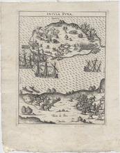
Insula Puna (1603)

Description: Map showing Isla Puna off present-day Ecuador. Europeans and Native Americans fight using guns or muskets. Settlement of dwellings and a church and boats being burned are seen in the background. There are ships and boats between the Island and the mainland. On the Mainland, Europeans attack Native Americans a who run away carrying a litter with someone inside it. The Cartographer, Levinus Hulsius, was a German writer who compiled an extensive collection of accounts of explorers' voyages published, ultimately, in twenty-six parts.
Member of: Antiquarian Maps Collection (1603-1863)
Resource Type: cartographic