1 - 7 of 7 records
Salzburg et Carinthis
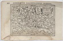
Description: This is a detailed copper engraved map depicting Salzburg, Austria and surrounding area. The map is filled with a lot of geographic details on cities, towns, rivers, lakes, mountains, and forests. The map is adorned with a decorative title cartouche. Cities, towns and other sites on this map: Seebruck, Paembrug, Rot (Rott am Inn), Reit (Raiten), Gronpach, Ettnhausn, and Tresperg (Trostberg), Lauffen (Laufen), Bergtolsgade (Berchtesgaden), Paling (Palling), Glanegk, S. Seno, Durnperg, S. Valtein, Germany, Kufsteyn (Kufstein), Griespach, Spittall, Kiezpuchl (Kitzbuhel), Brixem (Brixen im Thale), Rotenburg (Rattenberg), Hieburg, Krumler Taurn, Velbra, Vyrgijn (Virgen), Kyrburg, Dravus Flu (Drava River), Lienez (Lienz), Draburg (Oberdrauburg), Greifnburg (Greifenburg), Typliach, Katschach (Kotschach), S. Nonafus, Droplach (Tropolach), Cerunburg, Moderndorff, Saxnfelt, Spittal (Spittal an der Drau), Kellerberg, Federburg, Weißestein (Weißenstein), Osiach (Ostriach), Werd (Maria Wörth), Clangfurt (Klagenfurt), Czwaikirch, Glanach (Glainach), Kappl (Eisenkappel-Vellach/ Bad Eisenkappel), S. Philip, Wildnsteyn, Vockmark (Völkermarkt), Maijsnburg, S. Walpurg (St. Walburgen), Harnperg, S. Lamprecht, Stayn, Fraunbrug, Newmark, Scheyfling (Scheifling), Tyrnstayn, Altn Hosn (Althofen), Waytring (Wieting), Eberstayn (Eberstein), S. Veit (Sankt Veit an der Glan), Hardeck, S. Peter, Gurck (Gurk), S. Loerns, Melnycz, Racz, Klausegk, S. Veyt, Muraw (Murau), Halflat (Hallstatt Lake), Lamerding, Ifschel (Bad Ischl), Falkensteyn, Geimund (Gmunden), Frankirche, Masee, Talge, Aygn, S. Egidy, S. eter, Abtenew, S. Michael (Sankt Michael im Lungau), Velachertaurn, Mattsee (Mattsee), Saltzburg (Salzburg), Werffen (Werfen), Gradneck, Veld Dirchn, Mylstat, Hohnpruk, Mijlpag, Raurisser Taurn, Velachertaurn, Stal, Velach, CasteinTaurn, Pod, Hoss, Rauris, Dachsepach, Goldeckherhoff, ZaleZach Fl. (), Iorg, Zell (Zell-am See), Lofer, Austria, Daufers (Tures/Taufers), Bruneck (Bruneck/Brunico), Doblach (Toblach/Dobbiaco), S. Magdalena Vels (Santa Maddelena/Sankt Magdelena), Palussa (Paluzza), Adauur, Ponte Basse (Pontebba), Klein Taruys, Italy, Krayeck (Kranjska Gora), Porta des Pless, Slovenia Jodocus Hondius (1563-1612) was the founder of the family business of publishing and cartography started in Amsterdam, as well as one of the most important engravers of his time. Petrus Bertius was a Flemish theologian, historian, geographer, and cartographer born in Beveren (Flanders). In 1593 he became a librarian and professor of mathematics at the University of Leyden.
Member of: Antiquarian Maps Collection (1603-1863)
Resource Type: cartographic
German Heraldic Manuscript
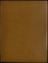
Description: Armorial manuscript, comprising 5 double-page sheets on thick, good-quality paper and mounted at an early date. 96 shields per page (half a sheet), each finely drawn in pen and ink with original watercolour, names below in brown ink. Light age browning, old damp stain to foot of one sheet, small tearing to one lower corner. A unique volume in modern tan calf with gold tooling, spine with raised bands and double gilt-line decoration. 45 x 34.5 cm
Resource Type: Text
JM-164: Will there be enough to go round?
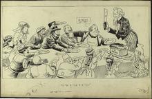
Description: This cartoon depicts Uncle Sam trying to divide "U.S. Bread" among various nations. In 1915, World War I was being fought in Europe, but the United States was maintaining a neutral position. Despite its neutrality, the United States supplied resources and arms to nations during the war. All of the countries sitting at the table are nations who lobbied for resources from the United States during the war. England is attempting to block Germany's chance of receiving resources from Uncle Sam. This is representative the attempts of the British government to limit the United States aid to Allied Powers, most often England. The United States is also sitting at the table, looking worried about sharing the beard with other nations. The United States distributing more resources than it could afford was a fear for many Americans in the 1910s. (Summary created by Mary Delano, MU History Intern, Spring 2018)
Member of: McCutcheon Editorial Cartoons - ALL (Collection)
Resource Type: Still Image
JM-282: The interrupted merger
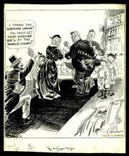
Description: Editorial cartoon depicting the wedding of Austria and Germany stopped by France.
Member of: McCutcheon Editorial Cartoons - ALL (Collection)
Resource Type: Still Image
JM-089: Cartoons of the day
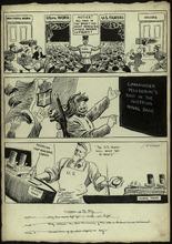
Description: Editorial cartoon depicting three panels, each one containing a different cartoon. In the first panel, General Crowder directs men over draft age into either a door marked "U.S. Fighters" or "Useful work." In the second panel, men toss hands and smile at sign with "Commander Pellegrini's raid in the Austrian naval base" displayed. In the last panel, a man representing the U.S. remarks on how the 10,000 tons of ships built each day in the U.S. will beat the U-boats.
Member of: McCutcheon Editorial Cartoons - ALL (Collection)
Resource Type: Still Image
Zeichnet vierte österreichische Kriegsanleihe
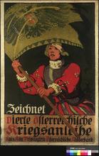
Description: Poster shows a 16th century soldier holding up a flag with the Austro-Hungarian double-headed Imperial eagle on it. Text: Subscribe to the 4th Austrian War Loan.
Resource Type: Still Image
Austro-Hungarian Monarchy.
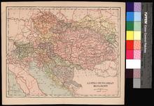
Description: On verso: Blank
Member of: Venable Maps
Resource Type: cartographic