1 - 6 of 6 records
Empire Francais et Royaume d'Italie (1812)

Description: Detailed single page historical copper engraved map of the French Empire. This map depicts France, North and Central Italy, Northern Spain, Belgium, Luxembourg, Germany, Switzerland, Monaco, Andorra, San Marino, and parts of Austria, Croatia, Slovenia, England, and Wales. The map shows several geographic details on cities, towns, rivers, mountains, and islands. The map includes an inset map int the top right quadrant showing the Netherlands. The map features a vignette incorporating the title. Cities appearing on this map include: Italy: Domodossola, Sondrio, Bormio, Udine, Spilemberg (Spilimbergo), Tolmezzo, Piave di Cadore (Pieve di Cadore), Bellune (Belluno), Felire (Feltre), Brixen, Pruneken (Bruneck), Sterzing, Bolzano, Meran (Merano), Glurens (Glurns), Cles, Neumarkt, Trente (Trento), Preor (Preore), Brio (?), Cividale, Varallo (Varallo Pombia), Ivree (Ivrea), Santia (Santhià), Chivasso, Turin, Aoste (Aosta), Suze (Susa), Riva (Riva del Garda), Salo (Salò), Schio, Verone, (Verona) Castiglione (Castiglione delle Stiviere), Mantoue (Mantua), Clusone, Lecco, Bergame (Bergamo), Brescia, Chiari, Crema, Verolanova (Verloanuova), Lodi, Cremone (Cremona), Plaisance (Piacenza), Como, Arona, Gallarate, Monza, Milan, Novare (Novara), Vigevano, Pavie (Pavia), Verceil (Vercelli), Casal (Casale Monferrato), Voghera, Ceneda (Vittorio Veneto), Asiago, Bassano (Bassano del Grappa), Trevise (Treviso), Franco (Castelfranco Veneto), Vicenze (Vicenza), Padoue (Padua), Venise (Venice), Este, Adria, Rovigo, Pordenone, Conegliano, Trieste, Gorice (Gorizia), Gradisca (Gradisca d'Isonzo), Aquilija (Aquileia), Valence (Valenza), Marengo (Spinetta Marengo), Alexandrie (Alessandria), Novi (Novi Ligure), Aqui (Acqui Terme), Chiavari, Gene (Genoa), Montenotte (Cairo Montenotte), Savone (Savona), Asti, Alba, Ceva, Coni (Cuneo), Saluces (?), Savigliano, Pignerole (Pinerolo), Ferrare (Ferrara), Cento, Imola, Ravenne (Ravenna), Faenza, Forli (Forlì), Bologne (Bologna), Modene (Modena), Mirandolle (Mirandola), Guastalla, Casalmaggiore, Reggio (Reggio Emilia), Vergato, Fiorenzuola (Fiorenzuola d'Arda), Bobbio, Bardi, Parme (Parma), Fornovo (Fornovo di Taro), Villafranca, Brugnato, Sarzana, Rimini, Cervia, Fermo, Tolentino, Macerata, Ancone (Ancona), Sinigaglia (Senigallia), Fano, Pesaro, Urbino, Jesi, Cagli, Fabriano, Camerino, Assisi, Perugia, Fratta, Arezzo, Mt. Alcino (Montalcino), Massa (Massa Marittima), Sienne (Siena), Volterra, Livourne (Livorno), Pisa, Empoli, Florentis (Florence), Pistoia, Lacques (Lucca), Massa, Port Maurice (Imperia or Porto Maurizio), S. Remo (Sanremo), Mt. Rotonda (Monti Sibillini), Popolo (Popoli), Aquila (L'Aquila), Chieti, Teramo, Ascoli (Ascoli Piceno), Mte. Ailo (Montalto delle Marche), Introdoca (Antrodoco), Rieti, Narni, Civita Castellana, Viterbe (Viterbo), Spoleto, Norcia, Foligno, Todi, Orvieto, Civita Vecchia (Civitavecchia), Toscanella (Tuscania), Acquapendente, Grosseto, Piombino, Porto Ferrajo (Portoferraio), Palo (Ladispoli), Peschio Asseroto, Tivoli, Ostui (Ostia), Rome, Veiletri (Velletri), Frosinone, Astura (Torre Astura), Ponte Corvo (Pontecorve), Terracine (Terracina), and Gaete (Gaeta). San Marino: San Marin (San Marino Cittia). Monaco: Monaco France: Corte, Vico, Calvi, I. Rousse (L'Île-Rousse), S. Florent (Saint-Florent), Bastia, Pto. Vecchio (Porto-Vecchio), Sartene (Sartène), Valinco, Ajaccio, Zicavo, Collioure, Perpignan, Salces (Salses-le-Château), Prades, Ax (Ax-les-Thermes), Foix, and S. Girons (Saint-Girons), Puget-Theniers (Puget Thèniers), Nice, Castellane, Grasse, Frejus (Frèjus), Draguignan, St. Tropez (Saint-Tropez), Toulon, La Ciotat, Marseille, Brignolles (Brignoles), Riez, Aix (Aix-en-Provence), Apt, Forcalquier, Arles, Tarascon, Avignon, Aiguesmortes (Aigues-Mortes), Montpellier, Cette (Sète), Nismes (Nîmes), Sijean (Sigean), Narbonne, Bèziers (Beziers), Lodeve (Lodève), St. Afrique (Saint-Affrique), La Canne (Lacaune), St. Pons (Saint-Pons-de-Thomières), Carcassonne, Limoux, Pamiers, Castelnaudary, Villefranche (Villefranche-de-Lauragais), Toulouse, Lavaur, Castres, Gaillac, Alby (Albi), Condom, Lectoure, Auch, Muret (?), Mirande (?), Lombes (Lombez), St. Gaudens (Saint-Gaudens), Mt. de Mansan (Mont-de-Marsan), St. Sever (Saint-Sever), Pau, Tarbes, Oliron (Oloron-Sainte-Marie), Bagneres (Bagnères-de-Bigorre), Argeles (Argelès-Gazost), Dax, Orthes (Orthez), Bayonne, Mauleon (Mauléon-Licharre), St. Jean de Lux (Saint-Jean-de-Luz), Briancon (Briançon), Embrna (Embrun), Barcelonnette, Digne (Digne-les-Bains), Sisteron, Gap, Corps, Die, Carpentras, Orange, Uzes (Uzès), Viviers, Nyons, Montelimart (Montélimar), Privas, Valence, Vernoux (Vernoux-en-Vivarais), Mende, L'Argentiere (Largentière), Florac, Alais (Alès), Le Vigan, Aurillac, S. Chely (Saint-Chély-d'Apcher), Espalion, Marvejols, Rhodez (Rodez), Milhau (Millau), Gourdon, Figeac, Cahors, Villefranche (Villefranche-de-Rouergue), Montauban, Bergerac, Sarlat (Sarlat-la-Canéda), Villereal (Villeréal), Velleneuve (Villeneuve-sur-Lot), Agen, Castel Sarasin (Castelsarrasin), Nerac (Nérac), Libourne, Bordeaux, La Reolle (La Réole), Langon, Garonne (Meilhan-sur-Garonne), Marmande, Bazas, Roquefort, Lipostey (Liposthey), S. Maurice (Bourg-Saint-Maurice), Moutiers (Moûtiers), Conflans (Albertville), S. Jean de Maurienne (Saint-Jean-de-Maurienne), Grenoble, S. Marcellin (Saint-Marcellin), la Tour du Pin (La Tour-du-Pin), Chambery (Chambéry), Quirieu (Bouvesse-Quirieu), Belley, Annecy, Trevoux (Trévoux), Villefranche (Villefranche-sur-Saône), Lyon, Vienne, St. Etienne (Saint-Étienne), Roussillon (Le Péage-de-Roussillon), Tournon (Tournon-sur-Rhône), Thiers, Montbrison, Ambert, Brioude, Issengeaux (Yssingeaux), le Puy (Le Puy-en-Velay), Riom, Clermont (Clermont-Ferrand), Issoire, Murat, St. Flour (Saint-Flour), Mauriac, Argentat, Brives (Brive-la-Gaillarde), Tulle, Ussel, Aubusson, Bourganeuf, St. Yrieix (Saint-Yrieix-la-Perche), Periqueux (Périgueux), Nontron, Rochechouart, Limoges, Riberac (Ribérac), Barbezieux (Barbezieux-Saint-Hilaire), Blaye, Jonzac, Angouleme (Angoulême), Cognac, St. Jean d'Angely (Saint-Jean-d'Angély), Medoc (Médoc), Lesparre (Lesparre-Médoc), Saintes, Marennes, Rochefort, Pontarlier, Thonon (Thonon-les-Bains), Bonneville, Poligny, Lons le Saunier (Lons-le-Saunier), St. Claude (Saint-Claude), Nantua, Verdun (Verdun-sur-le-Doubs), Chalons (Chalon-sur-Saône), Louhans (Louhans-Châteaurenaud), Macon (Mâcon), Bourg (Bourg-en-Bresse), Autun, Bourbonlancy (Bourbon-Lancy), Charolles, la Palisse (Lapalisse), Roanne, S. Amand (Saint-Amand-Montrond), Moulins, Montlucon (Montluçon), Gannat, Issoudun, Chateauroux (Châteauroux), la Chatre (La Châtre), Boussac, Gueret (Guéret), le Blanc (Le Blanc), Bellac, Chatellerault (Châtellerault), Poitiers, Confolens, Civray, Ruffec, Melle, Niort, Partenay (Parthenay), Bressuire, la Rochelle (La Rochelle), Fontenay (Fontenay-le-Comte), Mareuil (Mareuil-sur-Lay-Dissais), Napoleon (La Roche-sur-Yon), Montaigu, les Sables d'Olonne (Les Sables-d'Olonne), Ensisheim, Belfort, Altkirch, Lure, Baume (Baume-les-Dames), S. Hypolite (Saint-Hippolyte), Jussey, Langres, Champlitte, Vesoul, Gray, Besancon (Besançon), Dole, Beaune, Dijon, Semur (Semur-en-Auxois), Montbard, Chatillon (Châtillon-sur-Seine), Tonnerre, Avallon, Chat Chinon (Château-Chinon), Joigny, Auxerre, Clamecy, Nevers, la Charite (La Charité-sur-Loire), Sancerre, Cosne (Cosne-Cours-sur-Loire), Briare, Gien, Bourges, Romorantin (Romorantin-Lanthenay), Blois, Beaugency, Orleans (Orléans), Loches, Tours, Amboise, Vendome (Vendôme), S. Calais (Saint-Calais), Loudun, Chinon, Saumur, Angers, la Fleche (La Flèche), Tiffauges, Nantes, Beaupreau (Beaupréau), Ancenis, Segre (Segré), Chateaubriand (Châteaubriant), Chat. Gontier (Château-Gontier), Paimbaeuf (Paimbœuf), Savenay, Redon, Ploermel (Ploërmel), Vannes, l'Orient (Lorient), Lauterbourg, Haguenau, Saverne, Strasbourg, Sehlestadt (Sélestat), Colmar, Chat. Salins (Château-Salins), Sarrebourg, Luneville (Lunéville), St. Die (Saint-Dié-des-Vosges), Epinal (Épinal), Commercy, Nancy, Toul, Neufchateau (Neufchâteau), Mirecour, Chaalons (Châlons-en-Champagne), Vitry (Vitry-le-François), Bar (Bar-le-Duc), Vassy (Wassy), Chaumont, Bar sur Seine (Bar-sur-Seine), Arcis (Arcis-sur-Aube), Nogent (Nogent-sur-Seine), Troyes, St. Denis (Saint-Denis), Paris, Coulommiers, Meaux, Corbeil (Corbeil-Essonnes), Melun, Provins, Fontainebleau, Sens, Montargis, Mantes (Mantes-la-Jolie), Versailles, Dreux, Chartres, Etampes (Étampes), Verneuil (Verneuil-sur-Avre), Mortagne (Mortagne-au-Perche), Nogent le Rotrou (Nogent-le-Rotrou), Mamers, Chateaudun (Châteaudun), Falaise, Argentan, Domfront, Alencon (Alençon), Mayenne, le Mans (Le Mans), Vire, Mortain, Granville, Avranches, Fougeres (Fougères), Vitre (Vitré), Laval, Rennes, S. Malo (Saint-Malo), Dinan, Monfort (Montfort-sur-Meu), Napoleonville (Pontivy), Loudeac (Loudéac), Lannion, Guingamp, St. Brieux (Saint-Brieuc), Morlaix, Brest, Chateaulin (Châteaulin), Quimper, Audierne, Wissenburg (Wissembourg), Sarreguemines, Metz, Briey, Thionville, Verdun, Ste. Menehould (Sainte-Menehould), Vouziers, Montmedy (Montmédy), Rethel, Sedan, Mezieres (Charleville-Mézières), Rocroy (Rocroi), Epernay (Épernay), Chat. Thierry (Château-Thierry), Rheims (Reims), Soissons, Laon, la Fere (La Fère), and Vervins, Senlis, Clermont, Compiegne (Compiègne), Montdidier, St. Quentin (Saint-Quentin), Peronne (Péronne), Pontoise, Vernon, Gd. Andelys (Les Andelys), Beauvais, Breteuil (Breteuil-sur-Noye), Amiens, Neufchatel (Neufchâtel-en-Bray), Evreux (Évreux), Bernay, Pt. Audemer (Pont-Audemer), Louviers, Rouen, Yvetot, Fecamp (Fécamp), S. Vallery (Saint-Valery-en-Caux), Dieppe, Lizieux (Lisieux), P. leveque (Pont-l'Évêque), Caen, le Havre (Le Havre), Bayeux, S. Lo (Saint-Lô), Valognes, Coutances, Cherbourg (Cherbourg-Octeville) Givet, Conde (Vieux-Condé), Maubeuge, Avesnes (Avesnes-sur-Helpe), Lille, Hazebrouck, Bethune (Béthune), Douay (Douai), Arras, Cambray (Cambrai), Doulens (Doullens), Treport (Le Tréport), Abbeville, Montreuil, S. Pol (Saint-Pol-sur-Ternoise), Boulogne (Boulogne-sur-Mer), St. Omer (Saint-Omer), Calais and Dunkerque (Dunkirk). Spain: Palamos (Palamós), Alataro, Barcelone (Barcelona), Manresa, Cervera, San Sadurme, Pons (Ponts), Balaguer, Lerida (Lleida), Barbastro, Sarinena (Sariñena), Zuerca (Zuera), Saragosse (Zaragoza), Calatayud, Girone (Girona), Ripoll, Roses, Peralada, Puigcerda (Puigcerdà), Solsona, Uirgel (La Seu d'Urgell), Povla (La Pobla de Segur), Ainsa (Aínsa), Benavarre (Benabarre), Huesca, Jaca, Sanguessa (Sangüesa), Roncevalles (Roncesvalles), Pampelune (Pamplona), Estella (Estella-Lizarra), Malagro (Milagro), Tudela, Vittoria (Vitoria-Gasteiz), Miranda de Ebro, Frias (Frías), Saldana (Saldaña), Savero (Sabero), Leon (León), Fontarabie (Hondarribia), Santestevan (?), S. Sebastien (San Sebastián), Deba, Laredo, Valmaseda (Balmaseda), Santander, S. Pedro (?), Vasieda (?), Llanes, Infiesto, el Campo (Campo de Caso), Riba de Sella (Ribadesella), Willaviciosa (Villaviciosa), and Gixcon (Gijón). Croatia: Fiume (Rijeka), Rovigno (Rovinj), and Omago (Umag). Slovenia: Capo d'Istria (Koper), Stein (Kamnik), and Ratmansdorf (Radovljica). Austria: Ferlach, Volkelmarkt (Völkermarkt), Strasbourg (Straßburg), Clagenfurt (Klagenfurt), Gmund (Gmünd), Villach, Lienz, Altenmarkt (Altenmarkt bei Sankt Gallen), Judenbourg (Judenburg), Unt Haus (?), Rottemann (Rottenmann), Murau, Salzbourg (Salzburg), Radstadt, Damsweg (Tamsweg) Kufstein, Schwaz, Innspruck (Innsbruck), Landek (Landeck), Imst, Bregentz (Bregenz), Feldkirch, Steyr, Linz, Wels, Scharding (Schärding), Ried (Ried im Innkreis), and Braun (Braunau am Inn). Germany: Bergtesgaden (Berchtesgaden), Mittenwald, Schong (Schongau), Kaufbeuren, Memmingen, Moesckirch (Messkirch), Geislingen (Geisingen), Constance (Konstanz), Freybourg (Freiburg im Breisgau), Passau, Wasserbourg (Wasserburg am Inn), Haag (Haag in Oberbayern), Munich, Dingelfing (Dingolfing), Neustadt (Neustadt an der Donau), Ingolstadt, Rain, Augsbourg (Augsburg), Nordlingen (Nördlingen), Ulm, Biberach (Biberach an der Riss), Canstadt (Bad Cannstatt), Carlsruhe (Karlsruhe), Stuttgard (Stuttgart), Tubingen (Tübingen), Gamerdingen (Gammertingen), Ettenheim, Offenbourg (Offenburg), Kehl, Darmstadt, Manheim (Mannheim), Spire (Speyer), Bingen (Bingen am Rhein), Simmern, Kirn, Worms, Kaiserslautern, 2 Ponts (Zweibrücken), Landau, Sarrebruck (Saarbrücken), Birkenfeld, Treves (Trier), Giessen, Weilbourg (Weilburg), Francfort (Frankfurt), Neustadt (?), Siegen, Neu Wied (Neuwied), Coblentz (Koblenz), Mayence (Mainz), Cologne, Siegberg (Siegburg), Juliers (Jülich), Bonn, Blankenheim, Pruym (Prüm), Sinsig (Sinzig), Bitbourg (Bitburg), Dasbourg (Dasburg), Aix la Chapelle (Aachen), Lipstadt (Lippstadt), Arensberg (Arnsberg), Lunen (Lünen), Wesel, Duisbourg (Duisburg), Dusseldorf (Düsseldorf), Creveld (Krefeld), Cleves (Kleve), Munster (Münster), Rees, Borken, Verden, Hoya, Nienburg, Minden, Detlingen (Dötlingen), Cloppenbourg (Cloppenburg), Quakenbruck (Quakenbrück), Osnabruck (Osnabrück), Meppen, Lengen (Lingen), Northorn (Nordhorn), Steinfurt, Travemunde (Travemünde), Lubeck (Lübeck), Lauenbourg (Lauenburg), Lunebourg (Lüneburg), Hambourg (Hamburg), Harbourg (Harburg), Rotenbourg (Rotenburg an der Wümme), Stade, Gluckstadt (Glückstadt), Cuxhaven, Bremerlehe (Bremerhaven), Gestendorf (Geestendorf), Osterholz, Bremen, Oldenbourg (Oldenburg), Jever, Aurich, and Emden. Switzerland: Salz (?), Meyenfeld (Maienfeld), Coire (Chur), Tusis (Thusis), Stans, Dissentis (Disentis), Bellinzone (Bellinzona), Locarno, Ingano (Lugano), Brigg (Brig-Glis), Brienz, Thun, Berne (Bern), Sion, Yverdun (Yverdon-les-Bains), Fribourg, Lausanne, Aubonne, S. Maurice (Saint-Maurice), Nyon, Geneve (Geneva), St. Gall (Sankt Gallen), Appenzell, Frauenfeld, Zurich (Zürich), Glaris (Glarus), Schweitz (Schwyz), Schafhausen (Schaffhausen), Lucerne, Soloure (?), Arau (Aarau), Delemont (Delémont), Bale (Basel), Bienne (Biel/Bienne, Poratrui (Porrentruy), and Neufchatel (Neuchâtel). Czech Republic: Rosenberg (Rožmberk nad Vltavou) Luxembourg: Luxembourg and Diekirck (Diekirch) Belgium: Neufchateau (Neufchâteau), Bouillon, Hasselt, Liege (Liège), Verviers, Malmedy S. Hubert (Saint-Hubert), Huy, Marche (Marche-en-Famenne), Dinant, Namur, Louvain (Leuven), Nivelles, Bruxelles (Brussels), Tournay (Tournai), Mons, Courtray (Kortrijk), Ypres, Peer, Turnhout, Anvers (Antwerp), Malines (Mechelen), Dendermonde, Ecloo (Eeklo), Gand (Ghent), Bruges, Ostende (Ostend), Nieuport (Nieuwpoort), and Furnes (Veurne). Netherlands: Maestricht (Maastricht), Nimegue (Nijmegen), Grave, Bois le Duc ('s-Hertogenbosch), Venlo, Ruremonde (Roermond), Breda, Berg op Zoom (Bergen op Zoom), Middelbourg (Middelburg), Axel, Arnheim (Arnhem), Thiel (Tioel), Dordrecht, Assen, Almeloo (Almelo), Amersfort (Amersfoort), Zutphen, Deventer, Zwol (Zwolle), Kainder (?), Heerenveen, Utrecht, la Have (The Hague), Leyde (Leiden), Amsterdam, Alkmaar, Hoorn, Vlinschoten (Winschoten), Groningue (Groningen), Leeuvarden (Leeuwarden), and Sneek. England: Hastings, New-Shoreham (Shoreham-by-Sea), Chichester, Dorchester, Bridport, Exeter, Plymouth, Launsceston (Launceston), Eddistone (?), Padstow, Penzanes (Penzance), Douvres (Dover), Margate, Canterbury, Colchester, Horsham, Tunbridge (Tonbridge), Windsor, Londres (London), Hertford, Oxford, Reading, Wincester (Winchester), Salisbury, Wells, Bath, Bristol, Glocester (Gloucester), and Bridgewater (Bridgwater). Wales: Caermarthen (Carmarthen). Source publication: Atlas Complet Du Precis De la Geographie Universelle De M. Malte Brun dressee par M. Lapie Capitaine Ingenieur Geographie Pierre M. Lapie (1779-1850) and his son Alexandre Emile Lapie (1809-1850) were French cartographers and engravers active in the early part of the 19th Century. The Lapies were commissioned officers in the French army holding the ranks of Colonel and Caipitan, respectively. Alexander enjoyed the title of "First Geographer to the King", and this title appears on several of his atlases. Both father and son were exceptional engraversand fastidious cartographers. Working separately and jointly they published four important atlases, an 1811 Atlas of the French Empire (Alexander), the 1812 Atlas Classique et Universel (Pierre), the Atlas Universel de Geographie Ancienne et Modern (joint issue), and the 1848 Atlas Militaire (Alexander). They also issued many smaller maps and independent issues. All of these are products of exceptional beauty and detail. Conrad Malte-Brun (1755-1826) was an important late 18th and early 19th Century Danish/French cartographer and revolutionary. Conrad was born in Thisted, Denmark. His parents encouraged him to a career in the Church, but he instead enrolled in the University of Copenhagen. In the liberal hall of academia Conrad became an ardent supporter of the French Revolution and the ideals of a free press. Despite the harsh censorship laws of crown prince Frederick VI, Malte-Brun published numerous pamphlets criticizing the Danish government. He was finally charged with defying censorship laws in 1799 and forced to flee to Sweden and ultimately France. Along with colleague Edme Mentelle, Malte-Brun published his first cartographic work, the Geographie mathematique, physique et politique de toutes les parties du monde (6 volumes published between 1803 and 1807). Conrad went on to found Les Annales des Voyages (in 1807) and Les Annales des Voyages, de la Geographie et de l'Histoire (in 1819). He also founded the Paris Societe de Geographie. In time, Conrad became known as one of the finest French cartographers of his time.
Member of: Antiquarian Maps Collection (1603-1863)
Resource Type: Still Image
Le Fort de la Kenoque. Situè dans la Comte de Flandre, sur la petite Riviere d'Yser a une Lieue au Sud Ouest de Dixmude. (1702)
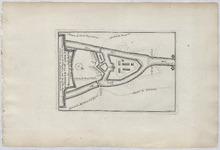
Description: This is a copper engraved plate depicting a bird's-eye plan of the fortress of Kenoque situated at the junction of the Loo and Diksmuide canals besieged by the British in 1695. The engraving shows details of the improvements to the fortress proposed by Vauban. The fortress was demolished in 1781. The publication this is from is Atlas portatif, ou, le nouveau theatre de la guerre en Europe: contenant les cartes géographiques, avec les plans des villes & forteresses les plus exposées aux révolutions présentes: accompagnè d'une nouvelle méthode pour apprendre facilement la géographie & la chronologie des potentats. Translated this is roughly: Portable Atlas, or thé new theater of war in Europe: containing maps, city maps with forts & most exposer to these revolutions: accompanied by a new method to easily learn geography & timelines. It was published in Amsterdam, Netherlands by Daniel de la Feuille in 1702. Daniel was born of Huguenot stock in Sedan (L'Ardennes) France. As a young man, he apprenticed as a watchmaker. In 1663 La Feuille married Charlette Marlet, the daughter of a local carpenter. Twenty years later, in 1683, facing religious persecution of the Huguenots in France, the family fled to Amsterdam. By 1686, Daniel had become a burgher (citizen) of the city and established himself as an engraver, publisher, and art dealer. Not long after, in 1691, he was admitted into the Booksellers Guild. His cartographic work includes numerous individual maps and atlases, many of which continued to be published and republished well after his death in 1709. He was succeeded by his sons Jacob and Paul.
Member of: Antiquarian Maps Collection (1603-1863)
Resource Type: cartographic
Partie Septentrionale de l'Empire Francais (1812)
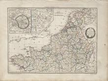
Description: Detailed single page historical copper engraved map of Northern France. The map also covers the Netherlands, parts of Germany, and Switzerland, most of which belonged to the French Empire at the time. The map shows several geographic details on cities, towns, rivers, mountains, and islands. The map includes two inset maps to top left quadrant entitled, "Environs de Paris: and "Holstein". The map features a vignette incorporating the title. Regions shown: Finisterre (Finistère), Morbihan, Loire Inferieure (Loire-Atlantique), Mayenne, Maine et Loire (Maine-et-Loire), Sarthe, Ille et Vilaine (Ille-et-Vilaine), Indre et Loire (Indre-et-Loire), Loir et Cher (Loir-et-Cher), Loiret, Cher, Yonne, Nievre (Nièvre), Cote D'Or (Côte-d'Or), Cotes du Nord, Manche, Orne, Calvados, Eure et Loir, Eure, Seine Inferieure, Seine et Oise, Seine, Seine et Marne, Oise, Aisne, Somme, Pas de Calais, Aube, Haute Marne, Haute Saone, Doubs, Haut Rhin, Vosge, Bas Rhin, Meurthe, Moselle, Meuse, Marne, Ardennes, Forets, Sambre et Meuse, Ourte, Sarre, Mont Tonnerre, Rhin et Moselle, Nord, Lys, Jemappes, Dyle, Escaut, Bouches de L'Escaut, Deux Nethes, Bou de la Meuse, Meuse Inferieure, Oer, Zuiderzee, Yssel Superieur, Bouches du Rhin, Lippe, Frise, Ems Occide, Ems Oriental, Ems Superieur, Bouches du Wesser, and Bouches de L'Elbe. Cities shown: Finisterre (Finistère): Concarneau, Quimperle (Quimperlé), Morbihan: Roche Bernard (La Roche-Bernard), l'Orient (Lorient), Vannes, Ploermel (Ploërmel), Loire Inferieure (Loire-Atlantique): Nantes, Ancenis, and Chateaubriand (Châteaubriant). Mayenne: Chateau Gontier (Château-Gontier), Maine et Loire (Maine-et-Loire): Angers, Segre (Segré), Bauge (Baugé-en-Anjou), and Saumur. Sarthe: Sable (Sablé-sur-Sarthe), la Fleche (La Flèche), S. Calais (Saint-Calais), Ille et Vilaine (Ille-et-Vilaine): Redon, Indre et Loire (Indre-et-Loire): Chateau Regnault (Château-Renault) and Tours. Loir et Cher (Loir-et-Cher): Montdoubleau (Mondoubleau), Vendome (Vendôme), Blois, and Romorantin (Romorantin-Lanthenay). Loiret: Beaugency, Meun (Meung-sur-Loire/Meung), Orleans (Orléans), Sully (Sully-sur-Loire), Briare, Gien, Chateau Renard (Château-Renard), Montargis, Cher: Sancerre. Yonne: S. Fargeau (Saint-Fargeau), S. Sauveur (Saint-Sauveur-en-Puisaye), Nievre (Nièvre): Cosne (Cosne-Cours-sur-Loire) and Clamecy. Cote D'Or (Côte-d'Or): Semur (Semur-en-Auxois), Montbard, Chatillon (Châtillon-sur-Seine), Recey (Recey-sur-Ource), Chanceaux, and Dijon. Source publication: Atlas Complet Du Precis De la Geographie Universelle De M. Malte Brun dressee par M. Lapie Capitaine Ingenieur Geographie Pierre M. Lapie (1779-1850) and his son Alexandre Emile Lapie (1809-1850) were French cartographers and engravers active in the early part of the 19th Century. The Lapies were commissioned officers in the French army holding the ranks of Colonel and Caipitan, respectively. Alexander enjoyed the title of "First Geographer to the King", and this title appears on several of his atlases. Both father and son were exceptional engraversand fastidious cartographers. Working separately and jointly they published four important atlases, an 1811 Atlas of the French Empire (Alexander), the 1812 Atlas Classique et Universel (Pierre), the Atlas Universel de Geographie Ancienne et Modern (joint issue), and the 1848 Atlas Militaire (Alexander). They also issued many smaller maps and independent issues. All of these are products of exceptional beauty and detail. Conrad Malte-Brun (1755-1826) was an important late 18th and early 19th Century Danish/French cartographer and revolutionary. Conrad was born in Thisted, Denmark. His parents encouraged him to a career in the Church, but he instead enrolled in the University of Copenhagen. In the liberal hall of academia Conrad became an ardent supporter of the French Revolution and the ideals of a free press. Despite the harsh censorship laws of crown prince Frederick VI, Malte-Brun published numerous pamphlets criticizing the Danish government. He was finally charged with defying censorship laws in 1799 and forced to flee to Sweden and ultimately France. Along with colleague Edme Mentelle, Malte-Brun published his first cartographic work, the Geographie mathematique, physique et politique de toutes les parties du monde (6 volumes published between 1803 and 1807). Conrad went on to found Les Annales des Voyages (in 1807) and Les Annales des Voyages, de la Geographie et de l'Histoire (in 1819). He also founded the Paris Societe de Geographie. In time, Conrad became known as one of the finest French cartographers of his time.
Member of: Antiquarian Maps Collection (1603-1863)
Resource Type: cartographic
JM-164: Will there be enough to go round?
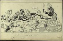
Description: This cartoon depicts Uncle Sam trying to divide "U.S. Bread" among various nations. In 1915, World War I was being fought in Europe, but the United States was maintaining a neutral position. Despite its neutrality, the United States supplied resources and arms to nations during the war. All of the countries sitting at the table are nations who lobbied for resources from the United States during the war. England is attempting to block Germany's chance of receiving resources from Uncle Sam. This is representative the attempts of the British government to limit the United States aid to Allied Powers, most often England. The United States is also sitting at the table, looking worried about sharing the beard with other nations. The United States distributing more resources than it could afford was a fear for many Americans in the 1910s. (Summary created by Mary Delano, MU History Intern, Spring 2018)
Member of: McCutcheon Editorial Cartoons - ALL (Collection)
Resource Type: Still Image
A New Mape of Ye XVII Provinces of Low Germanie
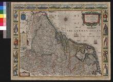
Description: Appeared in Speed's Prospect of the Most Famous Parts of the World (first published in 1627),On verso: Text: The Description of Belgia
Member of: Venable Maps
Resource Type: cartographic
Nobilis Hannoniae Comitatus Descrip.
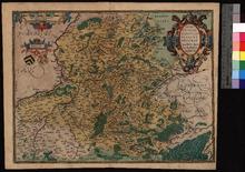
Description: Based on an unpublished 1548 map by Jacques Surhon; included in Theatrum Orbis Terrarum.,On verso: Text: Hannonia
Member of: Venable Maps
Resource Type: cartographic