1 - 15 of 26 records
Deutsche Luftkriegsbeute Austellung
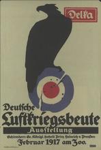
Description: At head of sheet: Delka.,Subject: German eagle perched on target.
Member of: World War I Posters (Collection)
Resource Type: Still Image
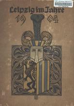
Leipzig im Jahre 1904
Member of: Louisiana Purchase Exposition: The 1904 St. Louis World's Fair (Collection)
Resource Type: Text
Salzburg et Carinthis
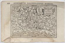
Description: This is a detailed copper engraved map depicting Salzburg, Austria and surrounding area. The map is filled with a lot of geographic details on cities, towns, rivers, lakes, mountains, and forests. The map is adorned with a decorative title cartouche. Cities, towns and other sites on this map: Seebruck, Paembrug, Rot (Rott am Inn), Reit (Raiten), Gronpach, Ettnhausn, and Tresperg (Trostberg), Lauffen (Laufen), Bergtolsgade (Berchtesgaden), Paling (Palling), Glanegk, S. Seno, Durnperg, S. Valtein, Germany, Kufsteyn (Kufstein), Griespach, Spittall, Kiezpuchl (Kitzbuhel), Brixem (Brixen im Thale), Rotenburg (Rattenberg), Hieburg, Krumler Taurn, Velbra, Vyrgijn (Virgen), Kyrburg, Dravus Flu (Drava River), Lienez (Lienz), Draburg (Oberdrauburg), Greifnburg (Greifenburg), Typliach, Katschach (Kotschach), S. Nonafus, Droplach (Tropolach), Cerunburg, Moderndorff, Saxnfelt, Spittal (Spittal an der Drau), Kellerberg, Federburg, Weißestein (Weißenstein), Osiach (Ostriach), Werd (Maria Wörth), Clangfurt (Klagenfurt), Czwaikirch, Glanach (Glainach), Kappl (Eisenkappel-Vellach/ Bad Eisenkappel), S. Philip, Wildnsteyn, Vockmark (Völkermarkt), Maijsnburg, S. Walpurg (St. Walburgen), Harnperg, S. Lamprecht, Stayn, Fraunbrug, Newmark, Scheyfling (Scheifling), Tyrnstayn, Altn Hosn (Althofen), Waytring (Wieting), Eberstayn (Eberstein), S. Veit (Sankt Veit an der Glan), Hardeck, S. Peter, Gurck (Gurk), S. Loerns, Melnycz, Racz, Klausegk, S. Veyt, Muraw (Murau), Halflat (Hallstatt Lake), Lamerding, Ifschel (Bad Ischl), Falkensteyn, Geimund (Gmunden), Frankirche, Masee, Talge, Aygn, S. Egidy, S. eter, Abtenew, S. Michael (Sankt Michael im Lungau), Velachertaurn, Mattsee (Mattsee), Saltzburg (Salzburg), Werffen (Werfen), Gradneck, Veld Dirchn, Mylstat, Hohnpruk, Mijlpag, Raurisser Taurn, Velachertaurn, Stal, Velach, CasteinTaurn, Pod, Hoss, Rauris, Dachsepach, Goldeckherhoff, ZaleZach Fl. (), Iorg, Zell (Zell-am See), Lofer, Austria, Daufers (Tures/Taufers), Bruneck (Bruneck/Brunico), Doblach (Toblach/Dobbiaco), S. Magdalena Vels (Santa Maddelena/Sankt Magdelena), Palussa (Paluzza), Adauur, Ponte Basse (Pontebba), Klein Taruys, Italy, Krayeck (Kranjska Gora), Porta des Pless, Slovenia Jodocus Hondius (1563-1612) was the founder of the family business of publishing and cartography started in Amsterdam, as well as one of the most important engravers of his time. Petrus Bertius was a Flemish theologian, historian, geographer, and cartographer born in Beveren (Flanders). In 1593 he became a librarian and professor of mathematics at the University of Leyden.
Member of: Antiquarian Maps Collection (1603-1863)
Resource Type: cartographic
Empire Francais et Royaume d'Italie (1812)

Description: Detailed single page historical copper engraved map of the French Empire. This map depicts France, North and Central Italy, Northern Spain, Belgium, Luxembourg, Germany, Switzerland, Monaco, Andorra, San Marino, and parts of Austria, Croatia, Slovenia, England, and Wales. The map shows several geographic details on cities, towns, rivers, mountains, and islands. The map includes an inset map int the top right quadrant showing the Netherlands. The map features a vignette incorporating the title. Cities appearing on this map include: Italy: Domodossola, Sondrio, Bormio, Udine, Spilemberg (Spilimbergo), Tolmezzo, Piave di Cadore (Pieve di Cadore), Bellune (Belluno), Felire (Feltre), Brixen, Pruneken (Bruneck), Sterzing, Bolzano, Meran (Merano), Glurens (Glurns), Cles, Neumarkt, Trente (Trento), Preor (Preore), Brio (?), Cividale, Varallo (Varallo Pombia), Ivree (Ivrea), Santia (Santhià), Chivasso, Turin, Aoste (Aosta), Suze (Susa), Riva (Riva del Garda), Salo (Salò), Schio, Verone, (Verona) Castiglione (Castiglione delle Stiviere), Mantoue (Mantua), Clusone, Lecco, Bergame (Bergamo), Brescia, Chiari, Crema, Verolanova (Verloanuova), Lodi, Cremone (Cremona), Plaisance (Piacenza), Como, Arona, Gallarate, Monza, Milan, Novare (Novara), Vigevano, Pavie (Pavia), Verceil (Vercelli), Casal (Casale Monferrato), Voghera, Ceneda (Vittorio Veneto), Asiago, Bassano (Bassano del Grappa), Trevise (Treviso), Franco (Castelfranco Veneto), Vicenze (Vicenza), Padoue (Padua), Venise (Venice), Este, Adria, Rovigo, Pordenone, Conegliano, Trieste, Gorice (Gorizia), Gradisca (Gradisca d'Isonzo), Aquilija (Aquileia), Valence (Valenza), Marengo (Spinetta Marengo), Alexandrie (Alessandria), Novi (Novi Ligure), Aqui (Acqui Terme), Chiavari, Gene (Genoa), Montenotte (Cairo Montenotte), Savone (Savona), Asti, Alba, Ceva, Coni (Cuneo), Saluces (?), Savigliano, Pignerole (Pinerolo), Ferrare (Ferrara), Cento, Imola, Ravenne (Ravenna), Faenza, Forli (Forlì), Bologne (Bologna), Modene (Modena), Mirandolle (Mirandola), Guastalla, Casalmaggiore, Reggio (Reggio Emilia), Vergato, Fiorenzuola (Fiorenzuola d'Arda), Bobbio, Bardi, Parme (Parma), Fornovo (Fornovo di Taro), Villafranca, Brugnato, Sarzana, Rimini, Cervia, Fermo, Tolentino, Macerata, Ancone (Ancona), Sinigaglia (Senigallia), Fano, Pesaro, Urbino, Jesi, Cagli, Fabriano, Camerino, Assisi, Perugia, Fratta, Arezzo, Mt. Alcino (Montalcino), Massa (Massa Marittima), Sienne (Siena), Volterra, Livourne (Livorno), Pisa, Empoli, Florentis (Florence), Pistoia, Lacques (Lucca), Massa, Port Maurice (Imperia or Porto Maurizio), S. Remo (Sanremo), Mt. Rotonda (Monti Sibillini), Popolo (Popoli), Aquila (L'Aquila), Chieti, Teramo, Ascoli (Ascoli Piceno), Mte. Ailo (Montalto delle Marche), Introdoca (Antrodoco), Rieti, Narni, Civita Castellana, Viterbe (Viterbo), Spoleto, Norcia, Foligno, Todi, Orvieto, Civita Vecchia (Civitavecchia), Toscanella (Tuscania), Acquapendente, Grosseto, Piombino, Porto Ferrajo (Portoferraio), Palo (Ladispoli), Peschio Asseroto, Tivoli, Ostui (Ostia), Rome, Veiletri (Velletri), Frosinone, Astura (Torre Astura), Ponte Corvo (Pontecorve), Terracine (Terracina), and Gaete (Gaeta). San Marino: San Marin (San Marino Cittia). Monaco: Monaco France: Corte, Vico, Calvi, I. Rousse (L'Île-Rousse), S. Florent (Saint-Florent), Bastia, Pto. Vecchio (Porto-Vecchio), Sartene (Sartène), Valinco, Ajaccio, Zicavo, Collioure, Perpignan, Salces (Salses-le-Château), Prades, Ax (Ax-les-Thermes), Foix, and S. Girons (Saint-Girons), Puget-Theniers (Puget Thèniers), Nice, Castellane, Grasse, Frejus (Frèjus), Draguignan, St. Tropez (Saint-Tropez), Toulon, La Ciotat, Marseille, Brignolles (Brignoles), Riez, Aix (Aix-en-Provence), Apt, Forcalquier, Arles, Tarascon, Avignon, Aiguesmortes (Aigues-Mortes), Montpellier, Cette (Sète), Nismes (Nîmes), Sijean (Sigean), Narbonne, Bèziers (Beziers), Lodeve (Lodève), St. Afrique (Saint-Affrique), La Canne (Lacaune), St. Pons (Saint-Pons-de-Thomières), Carcassonne, Limoux, Pamiers, Castelnaudary, Villefranche (Villefranche-de-Lauragais), Toulouse, Lavaur, Castres, Gaillac, Alby (Albi), Condom, Lectoure, Auch, Muret (?), Mirande (?), Lombes (Lombez), St. Gaudens (Saint-Gaudens), Mt. de Mansan (Mont-de-Marsan), St. Sever (Saint-Sever), Pau, Tarbes, Oliron (Oloron-Sainte-Marie), Bagneres (Bagnères-de-Bigorre), Argeles (Argelès-Gazost), Dax, Orthes (Orthez), Bayonne, Mauleon (Mauléon-Licharre), St. Jean de Lux (Saint-Jean-de-Luz), Briancon (Briançon), Embrna (Embrun), Barcelonnette, Digne (Digne-les-Bains), Sisteron, Gap, Corps, Die, Carpentras, Orange, Uzes (Uzès), Viviers, Nyons, Montelimart (Montélimar), Privas, Valence, Vernoux (Vernoux-en-Vivarais), Mende, L'Argentiere (Largentière), Florac, Alais (Alès), Le Vigan, Aurillac, S. Chely (Saint-Chély-d'Apcher), Espalion, Marvejols, Rhodez (Rodez), Milhau (Millau), Gourdon, Figeac, Cahors, Villefranche (Villefranche-de-Rouergue), Montauban, Bergerac, Sarlat (Sarlat-la-Canéda), Villereal (Villeréal), Velleneuve (Villeneuve-sur-Lot), Agen, Castel Sarasin (Castelsarrasin), Nerac (Nérac), Libourne, Bordeaux, La Reolle (La Réole), Langon, Garonne (Meilhan-sur-Garonne), Marmande, Bazas, Roquefort, Lipostey (Liposthey), S. Maurice (Bourg-Saint-Maurice), Moutiers (Moûtiers), Conflans (Albertville), S. Jean de Maurienne (Saint-Jean-de-Maurienne), Grenoble, S. Marcellin (Saint-Marcellin), la Tour du Pin (La Tour-du-Pin), Chambery (Chambéry), Quirieu (Bouvesse-Quirieu), Belley, Annecy, Trevoux (Trévoux), Villefranche (Villefranche-sur-Saône), Lyon, Vienne, St. Etienne (Saint-Étienne), Roussillon (Le Péage-de-Roussillon), Tournon (Tournon-sur-Rhône), Thiers, Montbrison, Ambert, Brioude, Issengeaux (Yssingeaux), le Puy (Le Puy-en-Velay), Riom, Clermont (Clermont-Ferrand), Issoire, Murat, St. Flour (Saint-Flour), Mauriac, Argentat, Brives (Brive-la-Gaillarde), Tulle, Ussel, Aubusson, Bourganeuf, St. Yrieix (Saint-Yrieix-la-Perche), Periqueux (Périgueux), Nontron, Rochechouart, Limoges, Riberac (Ribérac), Barbezieux (Barbezieux-Saint-Hilaire), Blaye, Jonzac, Angouleme (Angoulême), Cognac, St. Jean d'Angely (Saint-Jean-d'Angély), Medoc (Médoc), Lesparre (Lesparre-Médoc), Saintes, Marennes, Rochefort, Pontarlier, Thonon (Thonon-les-Bains), Bonneville, Poligny, Lons le Saunier (Lons-le-Saunier), St. Claude (Saint-Claude), Nantua, Verdun (Verdun-sur-le-Doubs), Chalons (Chalon-sur-Saône), Louhans (Louhans-Châteaurenaud), Macon (Mâcon), Bourg (Bourg-en-Bresse), Autun, Bourbonlancy (Bourbon-Lancy), Charolles, la Palisse (Lapalisse), Roanne, S. Amand (Saint-Amand-Montrond), Moulins, Montlucon (Montluçon), Gannat, Issoudun, Chateauroux (Châteauroux), la Chatre (La Châtre), Boussac, Gueret (Guéret), le Blanc (Le Blanc), Bellac, Chatellerault (Châtellerault), Poitiers, Confolens, Civray, Ruffec, Melle, Niort, Partenay (Parthenay), Bressuire, la Rochelle (La Rochelle), Fontenay (Fontenay-le-Comte), Mareuil (Mareuil-sur-Lay-Dissais), Napoleon (La Roche-sur-Yon), Montaigu, les Sables d'Olonne (Les Sables-d'Olonne), Ensisheim, Belfort, Altkirch, Lure, Baume (Baume-les-Dames), S. Hypolite (Saint-Hippolyte), Jussey, Langres, Champlitte, Vesoul, Gray, Besancon (Besançon), Dole, Beaune, Dijon, Semur (Semur-en-Auxois), Montbard, Chatillon (Châtillon-sur-Seine), Tonnerre, Avallon, Chat Chinon (Château-Chinon), Joigny, Auxerre, Clamecy, Nevers, la Charite (La Charité-sur-Loire), Sancerre, Cosne (Cosne-Cours-sur-Loire), Briare, Gien, Bourges, Romorantin (Romorantin-Lanthenay), Blois, Beaugency, Orleans (Orléans), Loches, Tours, Amboise, Vendome (Vendôme), S. Calais (Saint-Calais), Loudun, Chinon, Saumur, Angers, la Fleche (La Flèche), Tiffauges, Nantes, Beaupreau (Beaupréau), Ancenis, Segre (Segré), Chateaubriand (Châteaubriant), Chat. Gontier (Château-Gontier), Paimbaeuf (Paimbœuf), Savenay, Redon, Ploermel (Ploërmel), Vannes, l'Orient (Lorient), Lauterbourg, Haguenau, Saverne, Strasbourg, Sehlestadt (Sélestat), Colmar, Chat. Salins (Château-Salins), Sarrebourg, Luneville (Lunéville), St. Die (Saint-Dié-des-Vosges), Epinal (Épinal), Commercy, Nancy, Toul, Neufchateau (Neufchâteau), Mirecour, Chaalons (Châlons-en-Champagne), Vitry (Vitry-le-François), Bar (Bar-le-Duc), Vassy (Wassy), Chaumont, Bar sur Seine (Bar-sur-Seine), Arcis (Arcis-sur-Aube), Nogent (Nogent-sur-Seine), Troyes, St. Denis (Saint-Denis), Paris, Coulommiers, Meaux, Corbeil (Corbeil-Essonnes), Melun, Provins, Fontainebleau, Sens, Montargis, Mantes (Mantes-la-Jolie), Versailles, Dreux, Chartres, Etampes (Étampes), Verneuil (Verneuil-sur-Avre), Mortagne (Mortagne-au-Perche), Nogent le Rotrou (Nogent-le-Rotrou), Mamers, Chateaudun (Châteaudun), Falaise, Argentan, Domfront, Alencon (Alençon), Mayenne, le Mans (Le Mans), Vire, Mortain, Granville, Avranches, Fougeres (Fougères), Vitre (Vitré), Laval, Rennes, S. Malo (Saint-Malo), Dinan, Monfort (Montfort-sur-Meu), Napoleonville (Pontivy), Loudeac (Loudéac), Lannion, Guingamp, St. Brieux (Saint-Brieuc), Morlaix, Brest, Chateaulin (Châteaulin), Quimper, Audierne, Wissenburg (Wissembourg), Sarreguemines, Metz, Briey, Thionville, Verdun, Ste. Menehould (Sainte-Menehould), Vouziers, Montmedy (Montmédy), Rethel, Sedan, Mezieres (Charleville-Mézières), Rocroy (Rocroi), Epernay (Épernay), Chat. Thierry (Château-Thierry), Rheims (Reims), Soissons, Laon, la Fere (La Fère), and Vervins, Senlis, Clermont, Compiegne (Compiègne), Montdidier, St. Quentin (Saint-Quentin), Peronne (Péronne), Pontoise, Vernon, Gd. Andelys (Les Andelys), Beauvais, Breteuil (Breteuil-sur-Noye), Amiens, Neufchatel (Neufchâtel-en-Bray), Evreux (Évreux), Bernay, Pt. Audemer (Pont-Audemer), Louviers, Rouen, Yvetot, Fecamp (Fécamp), S. Vallery (Saint-Valery-en-Caux), Dieppe, Lizieux (Lisieux), P. leveque (Pont-l'Évêque), Caen, le Havre (Le Havre), Bayeux, S. Lo (Saint-Lô), Valognes, Coutances, Cherbourg (Cherbourg-Octeville) Givet, Conde (Vieux-Condé), Maubeuge, Avesnes (Avesnes-sur-Helpe), Lille, Hazebrouck, Bethune (Béthune), Douay (Douai), Arras, Cambray (Cambrai), Doulens (Doullens), Treport (Le Tréport), Abbeville, Montreuil, S. Pol (Saint-Pol-sur-Ternoise), Boulogne (Boulogne-sur-Mer), St. Omer (Saint-Omer), Calais and Dunkerque (Dunkirk). Spain: Palamos (Palamós), Alataro, Barcelone (Barcelona), Manresa, Cervera, San Sadurme, Pons (Ponts), Balaguer, Lerida (Lleida), Barbastro, Sarinena (Sariñena), Zuerca (Zuera), Saragosse (Zaragoza), Calatayud, Girone (Girona), Ripoll, Roses, Peralada, Puigcerda (Puigcerdà), Solsona, Uirgel (La Seu d'Urgell), Povla (La Pobla de Segur), Ainsa (Aínsa), Benavarre (Benabarre), Huesca, Jaca, Sanguessa (Sangüesa), Roncevalles (Roncesvalles), Pampelune (Pamplona), Estella (Estella-Lizarra), Malagro (Milagro), Tudela, Vittoria (Vitoria-Gasteiz), Miranda de Ebro, Frias (Frías), Saldana (Saldaña), Savero (Sabero), Leon (León), Fontarabie (Hondarribia), Santestevan (?), S. Sebastien (San Sebastián), Deba, Laredo, Valmaseda (Balmaseda), Santander, S. Pedro (?), Vasieda (?), Llanes, Infiesto, el Campo (Campo de Caso), Riba de Sella (Ribadesella), Willaviciosa (Villaviciosa), and Gixcon (Gijón). Croatia: Fiume (Rijeka), Rovigno (Rovinj), and Omago (Umag). Slovenia: Capo d'Istria (Koper), Stein (Kamnik), and Ratmansdorf (Radovljica). Austria: Ferlach, Volkelmarkt (Völkermarkt), Strasbourg (Straßburg), Clagenfurt (Klagenfurt), Gmund (Gmünd), Villach, Lienz, Altenmarkt (Altenmarkt bei Sankt Gallen), Judenbourg (Judenburg), Unt Haus (?), Rottemann (Rottenmann), Murau, Salzbourg (Salzburg), Radstadt, Damsweg (Tamsweg) Kufstein, Schwaz, Innspruck (Innsbruck), Landek (Landeck), Imst, Bregentz (Bregenz), Feldkirch, Steyr, Linz, Wels, Scharding (Schärding), Ried (Ried im Innkreis), and Braun (Braunau am Inn). Germany: Bergtesgaden (Berchtesgaden), Mittenwald, Schong (Schongau), Kaufbeuren, Memmingen, Moesckirch (Messkirch), Geislingen (Geisingen), Constance (Konstanz), Freybourg (Freiburg im Breisgau), Passau, Wasserbourg (Wasserburg am Inn), Haag (Haag in Oberbayern), Munich, Dingelfing (Dingolfing), Neustadt (Neustadt an der Donau), Ingolstadt, Rain, Augsbourg (Augsburg), Nordlingen (Nördlingen), Ulm, Biberach (Biberach an der Riss), Canstadt (Bad Cannstatt), Carlsruhe (Karlsruhe), Stuttgard (Stuttgart), Tubingen (Tübingen), Gamerdingen (Gammertingen), Ettenheim, Offenbourg (Offenburg), Kehl, Darmstadt, Manheim (Mannheim), Spire (Speyer), Bingen (Bingen am Rhein), Simmern, Kirn, Worms, Kaiserslautern, 2 Ponts (Zweibrücken), Landau, Sarrebruck (Saarbrücken), Birkenfeld, Treves (Trier), Giessen, Weilbourg (Weilburg), Francfort (Frankfurt), Neustadt (?), Siegen, Neu Wied (Neuwied), Coblentz (Koblenz), Mayence (Mainz), Cologne, Siegberg (Siegburg), Juliers (Jülich), Bonn, Blankenheim, Pruym (Prüm), Sinsig (Sinzig), Bitbourg (Bitburg), Dasbourg (Dasburg), Aix la Chapelle (Aachen), Lipstadt (Lippstadt), Arensberg (Arnsberg), Lunen (Lünen), Wesel, Duisbourg (Duisburg), Dusseldorf (Düsseldorf), Creveld (Krefeld), Cleves (Kleve), Munster (Münster), Rees, Borken, Verden, Hoya, Nienburg, Minden, Detlingen (Dötlingen), Cloppenbourg (Cloppenburg), Quakenbruck (Quakenbrück), Osnabruck (Osnabrück), Meppen, Lengen (Lingen), Northorn (Nordhorn), Steinfurt, Travemunde (Travemünde), Lubeck (Lübeck), Lauenbourg (Lauenburg), Lunebourg (Lüneburg), Hambourg (Hamburg), Harbourg (Harburg), Rotenbourg (Rotenburg an der Wümme), Stade, Gluckstadt (Glückstadt), Cuxhaven, Bremerlehe (Bremerhaven), Gestendorf (Geestendorf), Osterholz, Bremen, Oldenbourg (Oldenburg), Jever, Aurich, and Emden. Switzerland: Salz (?), Meyenfeld (Maienfeld), Coire (Chur), Tusis (Thusis), Stans, Dissentis (Disentis), Bellinzone (Bellinzona), Locarno, Ingano (Lugano), Brigg (Brig-Glis), Brienz, Thun, Berne (Bern), Sion, Yverdun (Yverdon-les-Bains), Fribourg, Lausanne, Aubonne, S. Maurice (Saint-Maurice), Nyon, Geneve (Geneva), St. Gall (Sankt Gallen), Appenzell, Frauenfeld, Zurich (Zürich), Glaris (Glarus), Schweitz (Schwyz), Schafhausen (Schaffhausen), Lucerne, Soloure (?), Arau (Aarau), Delemont (Delémont), Bale (Basel), Bienne (Biel/Bienne, Poratrui (Porrentruy), and Neufchatel (Neuchâtel). Czech Republic: Rosenberg (Rožmberk nad Vltavou) Luxembourg: Luxembourg and Diekirck (Diekirch) Belgium: Neufchateau (Neufchâteau), Bouillon, Hasselt, Liege (Liège), Verviers, Malmedy S. Hubert (Saint-Hubert), Huy, Marche (Marche-en-Famenne), Dinant, Namur, Louvain (Leuven), Nivelles, Bruxelles (Brussels), Tournay (Tournai), Mons, Courtray (Kortrijk), Ypres, Peer, Turnhout, Anvers (Antwerp), Malines (Mechelen), Dendermonde, Ecloo (Eeklo), Gand (Ghent), Bruges, Ostende (Ostend), Nieuport (Nieuwpoort), and Furnes (Veurne). Netherlands: Maestricht (Maastricht), Nimegue (Nijmegen), Grave, Bois le Duc ('s-Hertogenbosch), Venlo, Ruremonde (Roermond), Breda, Berg op Zoom (Bergen op Zoom), Middelbourg (Middelburg), Axel, Arnheim (Arnhem), Thiel (Tioel), Dordrecht, Assen, Almeloo (Almelo), Amersfort (Amersfoort), Zutphen, Deventer, Zwol (Zwolle), Kainder (?), Heerenveen, Utrecht, la Have (The Hague), Leyde (Leiden), Amsterdam, Alkmaar, Hoorn, Vlinschoten (Winschoten), Groningue (Groningen), Leeuvarden (Leeuwarden), and Sneek. England: Hastings, New-Shoreham (Shoreham-by-Sea), Chichester, Dorchester, Bridport, Exeter, Plymouth, Launsceston (Launceston), Eddistone (?), Padstow, Penzanes (Penzance), Douvres (Dover), Margate, Canterbury, Colchester, Horsham, Tunbridge (Tonbridge), Windsor, Londres (London), Hertford, Oxford, Reading, Wincester (Winchester), Salisbury, Wells, Bath, Bristol, Glocester (Gloucester), and Bridgewater (Bridgwater). Wales: Caermarthen (Carmarthen). Source publication: Atlas Complet Du Precis De la Geographie Universelle De M. Malte Brun dressee par M. Lapie Capitaine Ingenieur Geographie Pierre M. Lapie (1779-1850) and his son Alexandre Emile Lapie (1809-1850) were French cartographers and engravers active in the early part of the 19th Century. The Lapies were commissioned officers in the French army holding the ranks of Colonel and Caipitan, respectively. Alexander enjoyed the title of "First Geographer to the King", and this title appears on several of his atlases. Both father and son were exceptional engraversand fastidious cartographers. Working separately and jointly they published four important atlases, an 1811 Atlas of the French Empire (Alexander), the 1812 Atlas Classique et Universel (Pierre), the Atlas Universel de Geographie Ancienne et Modern (joint issue), and the 1848 Atlas Militaire (Alexander). They also issued many smaller maps and independent issues. All of these are products of exceptional beauty and detail. Conrad Malte-Brun (1755-1826) was an important late 18th and early 19th Century Danish/French cartographer and revolutionary. Conrad was born in Thisted, Denmark. His parents encouraged him to a career in the Church, but he instead enrolled in the University of Copenhagen. In the liberal hall of academia Conrad became an ardent supporter of the French Revolution and the ideals of a free press. Despite the harsh censorship laws of crown prince Frederick VI, Malte-Brun published numerous pamphlets criticizing the Danish government. He was finally charged with defying censorship laws in 1799 and forced to flee to Sweden and ultimately France. Along with colleague Edme Mentelle, Malte-Brun published his first cartographic work, the Geographie mathematique, physique et politique de toutes les parties du monde (6 volumes published between 1803 and 1807). Conrad went on to found Les Annales des Voyages (in 1807) and Les Annales des Voyages, de la Geographie et de l'Histoire (in 1819). He also founded the Paris Societe de Geographie. In time, Conrad became known as one of the finest French cartographers of his time.
Member of: Antiquarian Maps Collection (1603-1863)
Resource Type: Still Image
Partie Septentrionale de l'Empire Francais (1812)
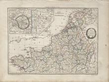
Description: Detailed single page historical copper engraved map of Northern France. The map also covers the Netherlands, parts of Germany, and Switzerland, most of which belonged to the French Empire at the time. The map shows several geographic details on cities, towns, rivers, mountains, and islands. The map includes two inset maps to top left quadrant entitled, "Environs de Paris: and "Holstein". The map features a vignette incorporating the title. Regions shown: Finisterre (Finistère), Morbihan, Loire Inferieure (Loire-Atlantique), Mayenne, Maine et Loire (Maine-et-Loire), Sarthe, Ille et Vilaine (Ille-et-Vilaine), Indre et Loire (Indre-et-Loire), Loir et Cher (Loir-et-Cher), Loiret, Cher, Yonne, Nievre (Nièvre), Cote D'Or (Côte-d'Or), Cotes du Nord, Manche, Orne, Calvados, Eure et Loir, Eure, Seine Inferieure, Seine et Oise, Seine, Seine et Marne, Oise, Aisne, Somme, Pas de Calais, Aube, Haute Marne, Haute Saone, Doubs, Haut Rhin, Vosge, Bas Rhin, Meurthe, Moselle, Meuse, Marne, Ardennes, Forets, Sambre et Meuse, Ourte, Sarre, Mont Tonnerre, Rhin et Moselle, Nord, Lys, Jemappes, Dyle, Escaut, Bouches de L'Escaut, Deux Nethes, Bou de la Meuse, Meuse Inferieure, Oer, Zuiderzee, Yssel Superieur, Bouches du Rhin, Lippe, Frise, Ems Occide, Ems Oriental, Ems Superieur, Bouches du Wesser, and Bouches de L'Elbe. Cities shown: Finisterre (Finistère): Concarneau, Quimperle (Quimperlé), Morbihan: Roche Bernard (La Roche-Bernard), l'Orient (Lorient), Vannes, Ploermel (Ploërmel), Loire Inferieure (Loire-Atlantique): Nantes, Ancenis, and Chateaubriand (Châteaubriant). Mayenne: Chateau Gontier (Château-Gontier), Maine et Loire (Maine-et-Loire): Angers, Segre (Segré), Bauge (Baugé-en-Anjou), and Saumur. Sarthe: Sable (Sablé-sur-Sarthe), la Fleche (La Flèche), S. Calais (Saint-Calais), Ille et Vilaine (Ille-et-Vilaine): Redon, Indre et Loire (Indre-et-Loire): Chateau Regnault (Château-Renault) and Tours. Loir et Cher (Loir-et-Cher): Montdoubleau (Mondoubleau), Vendome (Vendôme), Blois, and Romorantin (Romorantin-Lanthenay). Loiret: Beaugency, Meun (Meung-sur-Loire/Meung), Orleans (Orléans), Sully (Sully-sur-Loire), Briare, Gien, Chateau Renard (Château-Renard), Montargis, Cher: Sancerre. Yonne: S. Fargeau (Saint-Fargeau), S. Sauveur (Saint-Sauveur-en-Puisaye), Nievre (Nièvre): Cosne (Cosne-Cours-sur-Loire) and Clamecy. Cote D'Or (Côte-d'Or): Semur (Semur-en-Auxois), Montbard, Chatillon (Châtillon-sur-Seine), Recey (Recey-sur-Ource), Chanceaux, and Dijon. Source publication: Atlas Complet Du Precis De la Geographie Universelle De M. Malte Brun dressee par M. Lapie Capitaine Ingenieur Geographie Pierre M. Lapie (1779-1850) and his son Alexandre Emile Lapie (1809-1850) were French cartographers and engravers active in the early part of the 19th Century. The Lapies were commissioned officers in the French army holding the ranks of Colonel and Caipitan, respectively. Alexander enjoyed the title of "First Geographer to the King", and this title appears on several of his atlases. Both father and son were exceptional engraversand fastidious cartographers. Working separately and jointly they published four important atlases, an 1811 Atlas of the French Empire (Alexander), the 1812 Atlas Classique et Universel (Pierre), the Atlas Universel de Geographie Ancienne et Modern (joint issue), and the 1848 Atlas Militaire (Alexander). They also issued many smaller maps and independent issues. All of these are products of exceptional beauty and detail. Conrad Malte-Brun (1755-1826) was an important late 18th and early 19th Century Danish/French cartographer and revolutionary. Conrad was born in Thisted, Denmark. His parents encouraged him to a career in the Church, but he instead enrolled in the University of Copenhagen. In the liberal hall of academia Conrad became an ardent supporter of the French Revolution and the ideals of a free press. Despite the harsh censorship laws of crown prince Frederick VI, Malte-Brun published numerous pamphlets criticizing the Danish government. He was finally charged with defying censorship laws in 1799 and forced to flee to Sweden and ultimately France. Along with colleague Edme Mentelle, Malte-Brun published his first cartographic work, the Geographie mathematique, physique et politique de toutes les parties du monde (6 volumes published between 1803 and 1807). Conrad went on to found Les Annales des Voyages (in 1807) and Les Annales des Voyages, de la Geographie et de l'Histoire (in 1819). He also founded the Paris Societe de Geographie. In time, Conrad became known as one of the finest French cartographers of his time.
Member of: Antiquarian Maps Collection (1603-1863)
Resource Type: cartographic
Life of Luther
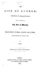
Description: "(Reprinted from the Christian's monthly magazine)."
Member of: All Books and Texts
Resource Type: Text
Absdorf Rentbook.
Description: "[Germany (Absdorf), 1529 and 1549] approximately 52 leaves, c.220mm. by 150mm., nn(a) 26 leaves of soft double-ply paper originally sewn in gatherings but now detached from binding, two columns, 11 lines, in a frame 170mm. by 118mm., written in red and black ink in various sizes of a large formal bookhand, notations in other hands, edges frayed and some leaves separating into their constituent layers, slight thumbing, wrapped in a stronger sheet of paper with the inscription 'Gruntpuech der Zins und Gult zu den Guet Abtstorf gehörig/Renovirt 1528 had der geleichen Hofmaister zu Abtsdorff', nn(b) 24 leaves of strong single-ply paper, collation: i–ii6, iii12, watermark: a gothic 'P' with a shield, close to Briquet, 'Filigranes', no. 8792 (Budweis, 1531), the last 8 leaves are cut away in a stepped fashion on the outer edge to make a thumb index, written in brown ink by various cursive hands, headings in an angular bookhand, some thumbing and signs of use, stitching broken, edges rather battered, wrapper of contemporary paper with inscription 'Grundtbuech Geen Intzlestorff, hern Jorgen Grabner zugehörig angefangen 1549', both loose in nineteenth-century bindingnnCATALOGUE NOTEnnThese documents are two extensive land-registers of the villages of Absdorf and Intzledorf, near St. Pölten in southern Austria, and while land-documents are common, ones of such size and scope are not. Both contain a mass of information on local rents and dues, and details of the produce of the area (mainly wine, cereal, saffron, hens, cheese, hay and garden produce). As well as an intrinsic historical value, these documents have some interest as two different approaches by two local officials to their record keeping. The 'Hofmaister zu Abtsdorff' who created the first book was principally concerned with creating a work of some beauty, allotting each individual landholder a whole page, having the pages ruled for only 11 lines, leaving wide margins, and writing the document (or employing a professional scribe to write it for him) in excellent German script, often with pen flourishes and cadels on the names of the individual landholders. The author of the second book (Jorgen Grabner) was under very different constraints, and produced a document that was functional rather than pleasing to the eye, with numerous additions of scribbled text and tables, crossing-outs, and erasures. This mass of information apparently left him in need of some organisation for his account, and so he added the alphabetical thumb-index. This is an early example of such a referencing system, and is notable for that fact alone."nnSome text & images were too far in the gutter to fully capture.nnFull pdf available, https://dl.mospace.umsystem.edu/mu/islandora/object/mu%3A447642/datastream/PDF/view
Resource Type: Text
German Heraldic Manuscript
Description: Armorial manuscript, comprising 5 double-page sheets on thick, good-quality paper and mounted at an early date. 96 shields per page (half a sheet), each finely drawn in pen and ink with original watercolour, names below in brown ink. Light age browning, old damp stain to foot of one sheet, small tearing to one lower corner. A unique volume in modern tan calf with gold tooling, spine with raised bands and double gilt-line decoration. 45 x 34.5 cm
Resource Type: Text
JM-178: Pan-Germany is swiftly becoming panicy Germany
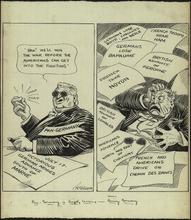
Description: This cartoon depicts a man who has been affected by news of combat in World War I. In the left panel, "Pan-Germany" is confident about his ability to win the war. Pan-Germany is a concept that stems from the ideology of Pan-Germanism. It is a school of thought, which believes all ethnic Germans and German-speaking people should be united under one state, Pan-Germany. While Pan-Germany was never a real state, Germanic peoples still shared a similar language and culture. In the right panel, Germany quickly becomes alarmed as news of Ally victory comes to his desk. Although Pan-Germany was confident of his ability to win World War I, he did not anticipate the United States becoming a serious threat to the war effort. The United States entered World War I on April 6, 1917. (Summary created by Mary Delano, MU History Intern, Spring 2018)
Member of: McCutcheon Editorial Cartoons - ALL (Collection)
Resource Type: Still Image
JM-021: Mr. American reactionary abroad tries to change the opinion of Europe
Description: Editorial cartoon depicting an American visiting places such as France, Germany, and Italy and hearing praise for Roosevelt, which the American does not agree with.
Member of: McCutcheon Editorial Cartoons - ALL (Collection)
Resource Type: Still Image
JM-171: Bi-plane dogfight
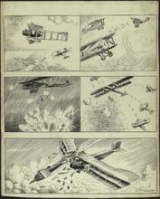
Description: Editorial cartoon depicting five panels of bi-plane dogfight scenes in World War 1. The planes with the iron cross symbol are German planes, while the planes with the roundels are either German or French.
Member of: McCutcheon Editorial Cartoons - ALL (Collection)
Resource Type: Still Image
JM-164: Will there be enough to go round?
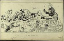
Description: This cartoon depicts Uncle Sam trying to divide "U.S. Bread" among various nations. In 1915, World War I was being fought in Europe, but the United States was maintaining a neutral position. Despite its neutrality, the United States supplied resources and arms to nations during the war. All of the countries sitting at the table are nations who lobbied for resources from the United States during the war. England is attempting to block Germany's chance of receiving resources from Uncle Sam. This is representative the attempts of the British government to limit the United States aid to Allied Powers, most often England. The United States is also sitting at the table, looking worried about sharing the beard with other nations. The United States distributing more resources than it could afford was a fear for many Americans in the 1910s. (Summary created by Mary Delano, MU History Intern, Spring 2018)
Member of: McCutcheon Editorial Cartoons - ALL (Collection)
Resource Type: Still Image
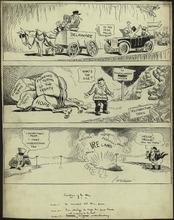
JM-184: Peace talk

Description: The cartoon shows the interpreted process of peace talks during World War I. The top panel shows the German people being dragged to peace by the Kaiser Wilhelm II. The second panel shows the Reichstag calling for peace after the kaiser orders them to begin discussions. In 1917, the United States had entered World War I, and Germany's and the Axis powers' chance of victory was becoming smaller and smaller. This made them more willing to negotiate for peace than in previous years of the war. The third panel shows the American stock market falling in value. This drop in the stock market was caused by the peace talks. Supplying weapons and other resources in World War I significantly improved the economy of the United States. Many factories and other means of productions had been created solely to meet the needs of the global conflict. As World War I came to a close, the United States large profits from the war effort began to decline. (Summary created by Mary Delano, MU History Intern, Spring 2018)
Member of: McCutcheon Editorial Cartoons - ALL (Collection)
Resource Type: Still Image
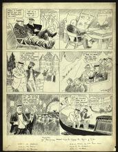
JM-202: Cartoons of the day
Description: Editorial cartoon depicting three separate cartoons. In the top panel, a man on a cart titled "Delaware" blocks women in cars titled "Suffrage" from passing him on the road to the 1920 polls. In the middle panel, "Germany" kills his pack horse ("Hope") underneath a burden of "Economic Terms of the Treaty"; he is unable to continue on "Reparation Trail". In the bottom panel, Uncle Sam and John Bull attempt to communicate via telephone, but uproar in Ireland blocks connection.
Member of: McCutcheon Editorial Cartoons - ALL (Collection)
Resource Type: Still Image
JM-203: Big Bills
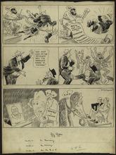
Description: Editorial cartoon depicting three scenes showing the reparations against Germany preventing the country from holding civilization again, the crime wave hitting Chicago even when one man believes he has ended it, and the G.O.P. elephant looking for a candidate but finding Taft being friendly with Wilson.
Member of: McCutcheon Editorial Cartoons - ALL (Collection)
Resource Type: Still Image