1 - 5 of 5 records
The Territorial papers of the United States, Volume 15. The territory of Louisiana-Missouri, 1815-1821. The Territory of Louisiana-Missouri, 1803-1821,Territory of Louisiana-Missouri, 1802-1821

Description: [v. 1]. 1803-1806 -- [v. 2]. 1806-1814 -- [v. 3] 1815-1821.,Issued by the Dept. of State as its Publication no. 3096, 3502; National Archives Publication 51-9.,Includes bibliographical references and indexes.
Member of: Territorial papers of the United States (Multi-volume set)
Resource Type: Text
The Territorial papers of the United States, Volume 14. The territory of Louisiana-Missouri, 1806-1814,Territory of Louisiana-Missouri, 1802-1821

Description: Issued by the Dept. of State as its Publication no. 3096, 3502; National Archives Publication 51-9.,Includes bibliographical references and indexes.,LSO ID: umlc000005.
Member of: Territorial papers of the United States (Multi-volume set)
Resource Type: Text
The Navigator: containing directions for navigating the Monongahela, Allegheny, Ohio and Mississippi Rivers ; with an ample account of these much admired waters, from the head of the former to the mouth of the latter ; and a concise description of their t

Description: Errata facing t.p.,Contains ms. notes.,LSO ID: umlc000008.
Member of: Missouriana: All Volumes (Collection)
Resource Type: Text
Camp-fire and cotton-field

Description: Book provided by University of Missouri -- Columbia
Member of: Missouriana: Civil War in Missouri (Collection)
Resource Type: Text
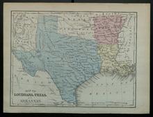
Map of Louisiana, Texas, and Arkansas

Description: Appeared in Mitchell's New Intermediate Geography (published in various editions between 1869 and 1901). Different editions were produced for different states.,On verso: Text: Louisiana, Texas
Member of: Venable Maps
Resource Type: cartographic