1 - 5 of 5 records
Baetica sive Hispania Pars Australis ut in Caesare descripta de Bello Hispanico (1739)
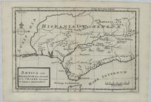
Description: This is a copper engraved historic map showing the Southern tip of Spain, Portugal, and Gibraltar as well as the Northern tip of Morocco. The map is filled with a lot of geographic details concerning place names in Latin. The title is inside a simple cartouche. The source publication is: Geographia antique, Latinorum et Graecorum, tabulis XXXII novis & accuratis expressa, translated: Thirty-two new and accurate maps of the geography of the ancients, as contained in the Greek and Latin Classics. It was printed and sold in 1739 in London by Thomas Bowles. Herman Moll was a Dutchman bookseller, geographer and engraver. Around 1678 he moved to London where for a while he continued as an engraver. Later, he started his own businesses a map publisher and by the turn of the century had become the most prominent map publisher in the country. He published atlases and loose maps of all parts of the world many of which were highly decorative. In 1724 he published his 'New Description of England and Wales', an atlas of the English and Welsh Counties. He had many interesting friends including Daniel Defoe, Jonathan Swift (for whom he provided maps for Robinson Crusoe and Gulliver's Travels), explorers William Damier and Woodes Rogers, and the scientist Robert Hooke. Cities, towns, and rivers shown on the map are Castulo (Destroyed in 1227), Baetis F. (Guadalquivir River), Castra Posthumy, Ategua (Fortified city at the time of Caesar), Ulla, Salsum F., Corduba (Córdoba), Sorita, Ucubis, Aspaula, Singulus F., Astigi (Écija), Crematur a Caesare, Urso, Malaca (Málaga), Italica (Roman City that Dwindled in the 3rd Century), Lenius F., Cilicensis F., Carmona, Obeulo, Hispalis (Sevilla), Carruca, Mare Internum (Mediterranean Sea), Munda, Asta, Carteia (Roman town that declined in the 9th Century), Fredum Gaditanum, Gades (Cádiz), Lusitania (Portugal and parts of Spain), and Hispania Ulterior (Southern Spain).
Member of: Antiquarian Maps Collection (1603-1863)
Resource Type: cartographic
JM-133: Portugal goes Republican
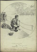
Description: This cartoon depicts King Manuel II fleeing Portugal after the Republican Revolution, which occurred in 1910. Before the revolution, Portugal had a constitutional monarchy, modeled in a similar fashion to that of Great Britain. In the decades before the revolution, the monarchy faced adversity by lower factions of society. The monarchy ruled Portugal in combination with aristocratic oligarchies, which maintained a relatively stable political status quo. Eventually, these oligarchies failed to maintain power, and the political situation in Portugal became increasingly unstable. Hatred for the monarchy grew to the point when King Carlos and his first son where jointly assassinated in 1908. Manuel II began to rule Portugal in his father's place, but failed to quell the urge to rebel among his people. On October 5, 1910, the violent revolution began in Lisbon, leaving hundreds dead in the struggle. Manuel II and his family fled, hoping to receive news that loyalist forces managed to overcome the revolutionaries. After realizing the revolutionaries had succeeded, Manuel II fled to England. The English government sympathized with the Portuguese monarchy. The new republican government maintained power and Portugal never returned to a constitutional monarchy structure. (Summary created by Mary Delano, MU History Intern, Spring 2018)
Member of: McCutcheon Editorial Cartoons - ALL (Collection)
Resource Type: Still Image
Accuratissima Totius Regni Hispaniae Tabula
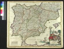
Description: On verso: Handwritten note (Bookseller)
Member of: Venable Maps
Resource Type: cartographic
Carte Itineraire, Physique, Politique, et Routiere de L'Espagne et du Portugal
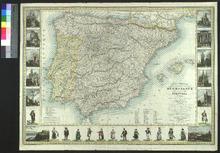
Description: Appeared as part of Richard & Quétin's Guide des Voyageurs en Espagne et en Portugal (the second edition of which was released in 1853). Variant forms of the map also appeared in other publications.,On verso: Blank
Member of: Venable Maps
Resource Type: cartographic
A New and Accurate Map of Spain and Portugal
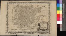
Description: Appeared in Moore's A new and complete collection of voyages and travels (1778),On verso: Blank
Member of: Venable Maps
Resource Type: cartographic