1 - 7 of 7 records
Baetica sive Hispania Pars Australis ut in Caesare descripta de Bello Hispanico (1739)
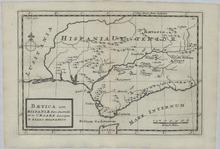
Description: This is a copper engraved historic map showing the Southern tip of Spain, Portugal, and Gibraltar as well as the Northern tip of Morocco. The map is filled with a lot of geographic details concerning place names in Latin. The title is inside a simple cartouche. The source publication is: Geographia antique, Latinorum et Graecorum, tabulis XXXII novis & accuratis expressa, translated: Thirty-two new and accurate maps of the geography of the ancients, as contained in the Greek and Latin Classics. It was printed and sold in 1739 in London by Thomas Bowles. Herman Moll was a Dutchman bookseller, geographer and engraver. Around 1678 he moved to London where for a while he continued as an engraver. Later, he started his own businesses a map publisher and by the turn of the century had become the most prominent map publisher in the country. He published atlases and loose maps of all parts of the world many of which were highly decorative. In 1724 he published his 'New Description of England and Wales', an atlas of the English and Welsh Counties. He had many interesting friends including Daniel Defoe, Jonathan Swift (for whom he provided maps for Robinson Crusoe and Gulliver's Travels), explorers William Damier and Woodes Rogers, and the scientist Robert Hooke. Cities, towns, and rivers shown on the map are Castulo (Destroyed in 1227), Baetis F. (Guadalquivir River), Castra Posthumy, Ategua (Fortified city at the time of Caesar), Ulla, Salsum F., Corduba (Córdoba), Sorita, Ucubis, Aspaula, Singulus F., Astigi (Écija), Crematur a Caesare, Urso, Malaca (Málaga), Italica (Roman City that Dwindled in the 3rd Century), Lenius F., Cilicensis F., Carmona, Obeulo, Hispalis (Sevilla), Carruca, Mare Internum (Mediterranean Sea), Munda, Asta, Carteia (Roman town that declined in the 9th Century), Fredum Gaditanum, Gades (Cádiz), Lusitania (Portugal and parts of Spain), and Hispania Ulterior (Southern Spain).
Member of: Antiquarian Maps Collection (1603-1863)
Resource Type: cartographic
Partie Occidentale de l'Empire Francais (1812)
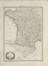
Description: Highly detailed single page historical copper engraved map of the Western part of France and the Northern part of Spain. The map shows several geographic details on cities, towns, rivers, mountains, and islands. The map features a vignette incorporating the title. Regions shown: Pyrenees Orientales (Pyrénées-Orientales), Aude, Arriege (Ariège), Haute Garonne (Haute-Garonne), Hautes Pyrenees (Hautes-Pyrénées), Basses Pyrenees (Pyrénées-Atlantiques), Gard, Herault (Hérault), Aveiron (Aveyron), Tarn, Tarn et Garonne (Tarn-et-Garonne), and Gers. Cities shown: France: Languedoc-Roussillon-Midi-Pyrénées: Pyrenees Orientales (Pyrénées-Orientales): Elne, Pt. Vendre (Port-Vendres), Ceret (Céret), Prats de Mollo (Prats-de-Mollo-la-Preste), Perpignan, St. Paul (Saint-Paul-de-Fenouillet), and Prades. Aude: Leucate, Ouillan (Quillan), Sijean (Sigean), la Grasse (Lagrasse), Narbonne, Castelnaudary, Carcassonne, and Limoux. Arriege (Ariège): Foix, Belesta (Bélesta), Tarascon (Tarascon-sur-Ariège), Ax (Ax-les-Thermes), St. Girons (Saint-Girons), Seix, Pamiers, and Mirepoix. Haute Garonne (Haute-Garonne): S. Beat (Saint-Béat), Bagneres de Luchen (Bagnères-de-Luchon), St. Gaudens (Saint-Gaudens), St. Bertrand (Saint-Bertrand-de-Comminges), Muret, Villefranche (Villefranche-de-Lauragais), Toulouse, Grenade, Caraman, and Villemur (Villemur-sur-Tarn). Hautes Pyrenees (Hautes-Pyrénées): Barreges (Barèges), Argelles (Argelès-Gazost), Lourde (Lourdes), Bagneres (Bagnères-de-Bigorre), la Barthe (La Barthe-de-Neste), Castelnau (Castelnau-Magnoac), Tarbes, and Vic Bigorre (Vic-en-Bigorre). Gard: Avignon, Tarascon, Nismes (Nîmes), Arles, Sommieres (Sommières), St. Hypolitte (Saint-Hippolyte-du-Fort), le Vigan (Le Vigan), and Aiguesmortes (Aigues-Mortes). Herault (Hérault): Montpellier, Frontignan, Cette (Sète), Agde, Pezenas (Pézenas), Lodeve (Lodève), Olargues, Beziers (Béziers), and St. Pens (?). Aveiron (Aveyron): St. Afrique (Saint-Affrique) and S. Sernin (Saint-Sernin-sur-Rance). Tarn: La Caune (Lacaune), Castres, Lavaur, Alby (Albi), Gaillac, and Rabastens. Tarn et Garonne (Tarn-et-Garonne): Beaumont (Beaumont-de-Lomagne), and Montauban. Gers: I'lle en Jourdain (L'Isle-Jourdain), Lombes (Lombez), Monfort, Lectoure, Auch, Simorre, Mirande (?), Vic Fezensac (Vic-Fezensac), Condom, Eauze (Éauze), Nogaro, and Plaisance. Aquitaine-Limousin-Poitou-Charentes: Basses Pyrenees (Pyrénées-Atlantiques): Laruns, Accous, Garlin, Pau, Oleron (Oloron-Sainte-Marie) Landes: Mont de Marsan (Mont-de-Marsan), St. Sever (Saint-Sever), Aire (Aire-sur-l'Adour) Spain: Catalonia: Province of Tarragona: Col de Balaguer (Coll de Balaguer), Perello (El Perelló), Tortose (Tortosa), Amposta, Momblanch (Montblanc), Cornudella (Cornudella de Montsant), Garcia, Miravet, Cambrils, and Tarragone (Tarragona). Province of Girona: Palamos (Palamós), Franciah (?), Tosa (Tossa de Mar), Hostalrich (Hostalric), La Junquiere (La Jonquera), Roses, Figuieres (Figueres), Castel Solit (?), Geronne (Girona), Puycerda (Puigcerdà), Ribas (Ribes de Freser), and Ripoll. Province of Barcelona: Malgrat (Malgrat de Mar), Cadella (Calella), Mataro (Mataró), Gronollers (Granollers), Barcelone (Barcelona), Sitjas (Sitges), S. Feliu (Sant Feliu de Llobregat), Martorell, Olesa (Olesa de Montserrat), Manresa, Cellent (Sallent), and Surla (Súria). Province of Lleida: Basella (Bassella), Pons (Ponts), Balaguer, Llor (?), Lerida (Lleida), Villagrasa (Vilagrassa), Sarroca (?), Urgel (La Seu d'Urgell), Malgrat (?), Castel Leon (?), Tirbia (?), Organya (Organyà), and Talarn. Aragon: Province of Huesca: Barbastro, Venasque (Benasque), Campo, Lastarre (?), Aguilar (?), Lascuare (Lascuarre), Almudorar (Almudévar), Anzanego (Anzánigo), Fiscal, Viescas (Biescas), Jaca, and Ayerbe. Province of Zaragoza: Osero (Osera de Ebro), Mequinenza, Foyon (Fayón), Alfoeea (?), Saragosse (Zaragoza), Escoron (?), Murillo (Murillo de Gállego), and Verdun (Berdún). Navarre: Province of Navarre: Caparroso, Navasques (Navascués), Pampelunne (Pamplona), Roncevalles (Roncesvalles), and Estella. La Rioja: Province of La Rioja: Logrono (Logroño). Castile and León: Province of Burgos: Miranda de Ebro. Basque Country: Province of Álava: Vitoria (Vitoria-Gasteiz). Province of Biscay: Orduna (Orduña). Cantabria: Province of Cantabria: Reynosa (Reinosa). Andorra: Andorre (Andorra la Vella) Source publication: Atlas Complet Du Precis De la Geographie Universelle De M. Malte Brun dressee par M. Lapie Capitaine Ingenieur Geographie Pierre M. Lapie (1779-1850) and his son Alexandre Emile Lapie (1809-1850) were French cartographers and engravers active in the early part of the 19th Century. The Lapies were commissioned officers in the French army holding the ranks of Colonel and Caipitan, respectively. Alexander enjoyed the title of "First Geographer to the King", and this title appears on several of his atlases. Both father and son were exceptional engraversand fastidious cartographers. Working separately and jointly they published four important atlases, an 1811 Atlas of the French Empire (Alexander), the 1812 Atlas Classique et Universel (Pierre), the Atlas Universel de Geographie Ancienne et Modern (joint issue), and the 1848 Atlas Militaire (Alexander). They also issued many smaller maps and independent issues. All of these are products of exceptional beauty and detail. Conrad Malte-Brun (1755-1826) was an important late 18th and early 19th Century Danish/French cartographer and revolutionary. Conrad was born in Thisted, Denmark. His parents encouraged him to a career in the Church, but he instead enrolled in the University of Copenhagen. In the liberal hall of academia Conrad became an ardent supporter of the French Revolution and the ideals of a free press. Despite the harsh censorship laws of crown prince Frederick VI, Malte-Brun published numerous pamphlets criticizing the Danish government. He was finally charged with defying censorship laws in 1799 and forced to flee to Sweden and ultimately France. Along with colleague Edme Mentelle, Malte-Brun published his first cartographic work, the Geographie mathematique, physique et politique de toutes les parties du monde (6 volumes published between 1803 and 1807). Conrad went on to found Les Annales des Voyages (in 1807) and Les Annales des Voyages, de la Geographie et de l'Histoire (in 1819). He also founded the Paris Societe de Geographie. In time, Conrad became known as one of the finest French cartographers of his time.
Member of: Antiquarian Maps Collection (1603-1863)
Resource Type: cartographic
Accuratissima Totius Regni Hispaniae Tabula
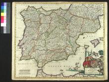
Description: On verso: Handwritten note (Bookseller)
Member of: Venable Maps
Resource Type: cartographic
The Humble address of the House of Commons to the Queen
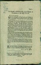
Description: Related to the victory by the Queen's army commanded by the Duke of Marlborough at Ramillies during the War of the Spanish Succession.,Caption title.,At head of title "[9]" "Numb. 3".,"(Price 1d.)"
Member of: Broadsides (Collection)
Resource Type: Text
Carte Itineraire, Physique, Politique, et Routiere de L'Espagne et du Portugal
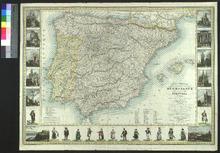
Description: Appeared as part of Richard & Quétin's Guide des Voyageurs en Espagne et en Portugal (the second edition of which was released in 1853). Variant forms of the map also appeared in other publications.,On verso: Blank
Member of: Venable Maps
Resource Type: cartographic
A New Chart of the English Channel, drawn from the Best Authorities. / A New Chart of the Coasts of France and Spain from L'Orient to Gibraltar, Drawn from the Best Authorities
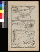
Member of: Venable Maps
Resource Type: cartographic
A New and Accurate Map of Spain and Portugal
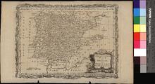
Description: Appeared in Moore's A new and complete collection of voyages and travels (1778),On verso: Blank
Member of: Venable Maps
Resource Type: cartographic