Loutre de Mer (1785)

Model
Image
Image
Description
First French edition Copper engraved plate showing a Sea Otter. Source publication: James Cook Troisieme Voyage de Cook, ou Voyage a l'Ocean Pacifique, Ordonne par le Roi d'Angleterre, pour Faire des Decouvertes dans l'Hémisphère Nord, pour déterminer la position & l'étendue de la Cote Ouest de l'Amérique Septentrionale, da distance de l'Asie, & résoudre la question du passage au Nord, translater as: James Cook: Third Cook travel, or travel to the Pacific Ocean, Ordered by the King of England, for Making Discoveries in the Northern Hemisphere, to Determine the Location & Extent of the West Coast of North America, the Distance of Asia, and the Transition to the North. The mapmaker James Cook (1728-1779) is a seminal figure in the history of cartography. In 1766, Cook was commissioned to explore the Pacific and given a Captaincy with command of the Endeavour. Three voyages of discovery followed, the highlights of which include the first European contact with Eastern Australia, the discovery of the Hawaiian Islands (and many other Polynesian Islands), the first circumnavigation of New Zealand, some of the first sightings of Antarctica, the first mapping of the Pacific Northwest, and his death at the hands of the Hawaiians in 1779.
Service File - Download

Carte de l'Isle d'Anjouan (1748)

Model
Image
Image
Description
This is a copper engraved map of the Island of Anjouan in the Comoros by Jacques Nicolas Bellin in 1748. It is labeled in both French and Dutch. The title in French is "Carte de l'Isle d'Anjouan, Une des Isles de Comore: Par le Cape. Cornwal" and in Dutch is "Kaart van't Eiland Anjuan, den der Komorose Eilanden, door Kapt. Cornwall". A rough English translation would be "A map of the Island of Anjouan, One of the Islands of the Comoros: Per Captain Cornwall. It shows a unit of measurement with the title, Echelle de quatre lieues marines in French and Schaal van Zee-Mylen in Dutch which translates to Scale of four marine leagues. Cities appearing on the map include: Kavane (?), Sakken (?), Marapare (?), Village:Dorp (?), Asanpon (?), Esoue (?), Eavil (?), Gindi (?), Mokeside (?), Bandane (?), Mindehore (?), Onzene (?), Kani (?), Bandankod (?), Bombo la Saunga (Bambao Mtrouni?), Lamude (?), Gaune (?), Bombae (?), Merone (?), Warne (?), Zeumillome (?), Haromt (?), Ponhal (?), Herovne (?), Bandanka (?), Boderan (?), Pinda (?), Suzane (?), Kova (?), Demoni (?), Koway (?), Namakil (?), Hada (?), and Demani (Domoni). Under Deamni it reads: Ville Capitale ou Demeure du Roy, Hoofdstad, which translated to Capital city or Residence of the King. Off of the Western Coast of the island it reads: Ici le Mouillage set fort bon: Hier is geode Ankering, which translated to, Here, anchorage is very good and Bancs de Roches sous l'eau, which translated to Rock Banks Under Water. On the Northern Portion of the island it reads: Tres bon endroit pour faire du bois: Beste Plaats voor den Houthak, which translates to, Very good place for wood/best place for logging.
Service File - Download

Carte De La Rade De Benguella et Riviere De Cantonbelle (1749)

Model
Image
Image
Description
This is a copper engraved map of Benguella in modern day Angola printed in 1749 Jacques-Nicolas Bellin. Bellin was a famous 18th century mapmaker who focused mainly on nautical and coastal maps. This map is titled Carte De La Rade De Benguella et Riviere De Cantonbelle, which is translated to Map of the Roadstead of Benguella and the Cantonbelle River. A shows Endroit de la Riviere de Cantonbelle ou les Chaloupes vont faire de l'eau, which roughly translated to The Place of the Cantonbelle River or where the Sloops are able to travel by water. B shows Bras de Mer ou il y a quanlite de Caymans et de Baeufs Marins, which roughly translated to Inlet or the Bay of Caymans and Bay of oxen. The units shown are Une Lieue Marine de France et d'Angleterre or a Marine League of France and England. The map shows Ville de Benguella (Benguela) including Petit Fortin Ruine (Ruins of the Little Fort) and F. S. Philippe (Forte de São Filipe de Benguela) as well as Village de Negres (?), and F. Kabuto (?). In F. Kabuto, it says Les Anglois marquent ici apres Mr. Delisle le Fort de Kabuto je ne scan sur quel sondement which roughly translates into The English and Mr. Delisle mark Fort Kabuto Here and I put it in based on them.
Service File - Download

Carte Generale De Espagne es du Portugal Par A. H. Brue, Geographe de S. A. R. Mousieuv. (1821)

Model
Image
Image
Description
This is a copper engraved map of Spain and Portugal from 1821 by Adrien Hubert Brue. The title of the map is Carte generale de l'Espagne en du Portugal, par A.H. Brue, Geographe de S.A.R. Monsieur. A Paris, Chez l'Auteur, rue des Macons-Sorbonne, no. 9, et chez les principaux marchands de geographie. Decembre 1821. This roughly translates to General Map of Spain and Portugal, by A. H. Brue, Geographe S. A. R. sir. In Paris at Rue des Macons-Sorbonne, No. 9 and at major geography merchants. December 1821. Countries appearing on this map: Morocco, Spain, Great Britain, Portugal, Cities appearing on this map: Morocco: Arsila (Asilah), Tanger (Tangier), Tetuan (Tétouan), Spain: Autonomous City of Cueta: Cueta. Andalusia: Province of Huelva: Te. la Higuera (?), Province of Cádiz: Ceuta, Salinas (?), Chipiona, Rota, San Lucar (Sanlúcar de Barrameda), Bornos, Arcos (Arcos de la Frontera), Xeres (Jerez de la Frontera), Pto. de Sa. Maria (El Puerto de Santa María), Pto. Real (Puerto Real), Paterna (Paterna de Rivera), Alcala (Alcalá de los Gazules), Medinasidonia (Medina-Sidonia), Chiclana (Chiclana de la Frontera), Renalia (?), Conil (Conil de la Frontera), S. Carlos (?), Cadix (Cádiz), Te. Bernuja (?), Veger (Vejer de la Frontera), C. de Plata (?), Tarifa, Algeciras, S. Roque (San Roque), Ximena (Jimena de la Frontera), Ubrique, Setenil (Setenil de las Bodegas), Pta. Serrano (Puerto Serrano), Grasalema (Grazalema), Province of Seville: las Cabezas (Las Cabezas de San Juan), Te. de Oreas (?), Lebrija, la Real Ca. del Cuervo (El Cuervo de Sevilla), Pruna, Province of Málaga: Gaucin (Gaucín), Estepona, Marbella, Te. de Cala Moral (?), Co. Licata (?), Coin (Coín), Alhaurin (Alhaurín el Grande), Monda, Turon (?), Ronda, Alora (Álora), Te. de Cala Moral (La Cala de Mijas), Te. Frangerola (Fuengirola), Te. Molinos (Torremolinos), Almogia (Almogía), Malaga (Málaga), Velez Malaga (Vélez-Málaga), Pinos del Rey (?), Torros (Torrox), Province of Granada: Almunecar (Almuñécar), Salobrena (Salobreña), Motril, Velez (Vélez de Benaudalla), Lanjaron (Lanjarón), Orgiva (Órgiva), Torbiscon (Torvizcón), Gualchos, Ce. de Rabida (La Rábita), Busqotar (Busquístar), Ugijar (Ugíjar), Province of Almería: Adra, Berja, Ce. de Guardas Viejas (Castillo de Guardias Viejas/Los Baños de Guardias Viejas/Guardias Viejas), Dalias (Dalías), Almeria (Almería), Rioja, Nijar (Níjar/San Isidro de Níjar)), Te. S. Miguel (San Miguel de Cabo de Gata), Te. de Calafiguera (?), Great Britain: Gibraltar: Gibraltar Portugal: Algarve Region: Faro District: N. Sa. de la Luz (Praia da Luz), Carrapateira, Aljesur (Aljezur), Seixe (Odeceixe), Monchique, Alentejo Region: Beja District: Serdao (Cavaleiro), Villanova de Milfontes (Vila Nova de Milfontes), Setúbal District: Sines,
Service File - Download

Carte De L'Empire Romain Sous Constantin, par A. H. Brue Geographe de S. A. R. Monsieuv. (1822)

Model
Image
Image
Description
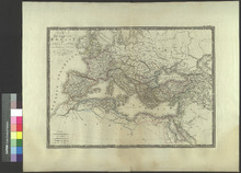
This is a copper engraved map of Europe from 1822 by Adrien Hubert Brue. The title of the map is Carte generale de l'Empire Romain sous Constantin, par A.H. Brue, Geographe de S.A.R. Monsieur. A Paris, Chez l'Auteur, rue des Macons-Sorbonne, no. 9, et chez les principaux marchands de geographie. Janvier 1822. This roughly translates to General Map of the Roman Empire under Constantine, by A. H. Brue, Geographe S. A. R. sir. In Paris at Rue des Macons-Sorbonne, No. 9 and at major geography merchants. January 1822. Constantine the Great (272-337) was the Emperor of Rome from 306-337. Countries appearing on this map: Egypt, Saudi Arabia, Libya, Jordan, Morocco, Algeria, Cities appearing on this map: Egypt: Apollinopolis Magna (Edfu), Syene (Aswan), Ombos (Naqada), Cataraetes (?), Pseleis (?), Berenice (Berenice Troglodytica abandoned in the 6th century), Hammon (?), Oasis Magna (Kharga Oasis), Latopolis (Esna), Hermunthis (Hermonthis), Thebae (Thebes, abandoned in the 1st Century), Apollinopolis Parva (Qus), Coptos (Qift), Tentyris (Dendera), Myosormos (Myos Hormos, abandoned after the 4th Century), Diospolis Parva (Hu), Abydus (Abydos, abandoned sometime after the 4th Century BC), Ptolemais (?), Chemmis vel Panopolis (Akhmim), Antaeopolis (Tjebu), Hypselis, Antinoe p. Besa (?), Hermopolis Magna (Hermopolis, abandoned sometime after the 3rd Century), Oasis Parva (Bahariya Oasis), Hepta (?), Oxyrynchus, Heracleopolis (Heracleopolis Magna, abandoned around 390), Arsinoe (Faiyum), Memphis (Abandoned in the 7th Century), Nomis (?), Aphroditopolis (Atfih), Clysma, Phaenicon (?), Pharan (Wadi Feiran), Apis, Paraetonium (Mersa Matruh), Derris extrema (?), Leucas Ptus. (?), Mareotis Lacus (Lake Mariout), Plinthinetes Sinus (Bay of Plinthine), Alexandria, Canopus (Abandoned sometime after 138 AD), Bolbitrium Ot. (Ancient Bolbitine Branch of the Nile), Bolbitine (Rosetta), Sais (Abandoned sometime after 525 BC), Sebennytus (Sebennytos which was abandoned sometime after the 3rd Century BC), Phatmeticum Ost. (Ancient Phatnitic branch of the Nile), Athribis (Abandoned sometime after the 4th Century AD), Heliopolis (Abandoned after the 6th Century AD), Bubastus (Bubastis which was abandoned after 449 AD), Heroopolis (Pithom which was abandoned sometime after the Roman era), Daphnes (?), Taphis (Abandoned sometime after 14 AD), Plusitum (?), Saudi Arabia: Iatrippa (Medina), Iambia (Yanbu), Madiana (?), Leuce (?), Phaemicon (?), Thumata (?), Magusa (?), Thaema (?), Negra (?), Libya: Garama (Germa), Augila (Awjila), Cydamus (Ghadames), Sabrata (Sabratha), Macomades Syrtis (?), Euphrantas Turris (?), Aspis Ptus. (?), Tubactis (?), Gerisa (Abandoned by the 11th Century), Oea vel Occa (Tripoli), Leptis Magna (Abandoned in the 7th Century), Darnis (Derna), Apollonia (Abandoned after 643), Cyrene (Abandoned in the 4th Century), Aplungis (?), Ptolemais (Abandoned in the 7th Century), Tauchira (Tocra), Hadriane (Deriana), Berenice (Benghazi), Axylis (?), Jordan: Aelana (Aqaba), Asiongaber (Ezion-Geber), Morocco: Adele (?), Cillaba (?), Fez, Volubilis (Abandoned by the 11th Century), Tremuli (?), Babba (?), Banasa (Iulia Valentia Banasa, abandoned around 285), Thamusida (Abandoned around 285), Sala (Chellah, abandoned in 1154), Exploratio ad Mercurium (?), Herpis (?), Algeria: Calaa (?), Mazices (?), Musalani (?), Desena (?), Vescerita vel Vescether (?), Tabudis (?), Tunisia: Pisida (?), Praesidium (?), Temp (?), Tacape (Gabès), Agiue Tu. (?), Thenae (Sfax), Taphrura (Sfax), Bizacina (?), Septimunica (?), Capsa (Gafsa), Telepte vel Tala (Thélepte), Tisurus (Tozeur), Libya Palus (?), Nepte (Nefta), Cyprus: Paphos,
Service File - Download

Vigilance et souvenir

Model
Image
Image
Description
At the top of the poster is a festoon with a lighted torch on both ends. To the left of the title is a soldier on the right is a scene of Paris in flames with Notre Dame in the foreground. Beneath the title is a wreath with a soldier's helmet and weapon and a red, white and blue ribbon. Underneath the festoon, text is organized in a numbered list, printed in two columns.,Translation of title: Vigilance and remembrance: thirty German crimes.,At head of sheet: Alliance Universitaire Française.,MU: Poster mounted on canvas and encaspsulated. Stamped on back: University of Missouri Library, Oct. 29, 1947.
Service File - Download

Ordonnance portant taxation de la vente au détail du sucre dans la Départment de la Seine

Model
Image
Image
Description
At head of title: République Française, Liberté Egalité Fraternité, Préfecture de Police, 2e Division, 3e Bureau.,3520-16.,Paris, le 3 Octobre 1916.,Translation of title: Order for taxation of retail sale of sugar in the Department of the Seine.,MU: Poster mounted on canvas and encapsulated. Stamped on back: University of Missouri Library, Oct. 30, 1947.,Regulations regarding the retail sale of sugar, including maximum prices.
Service File - Download

Ramassage des marrons d'inde et des chataignes

Model
Image
Image
Description
Translation of title: Collecting horse-chestnuts and chestnuts.,At head of title: République Française ..., Ministère de l'Agriculture, Service de la Main-d'œuvre Scolaire.,MU: Poster mounted on canvas and encapsulated. Stamped on back: University of Missouri Library, Oct. 30, 1947.
Service File - Download