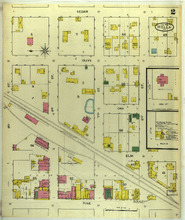
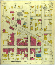
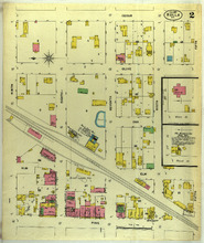
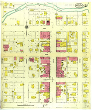
Rolla, Missouri, 1893 June, sheet 2 Image Rolla, Missouri, June 1893. Streets: Cedar, Olive, Oak, Elm, Pine, 9th (Ninth) Street, 8th (Eighth) Street, 7th (Seventh) Street, 6th (Sixth) Street Member of Rolla, Missouri maps
Rolla, Missouri, 1884 April Image Rolla, Missouri, April 1884. Streets: Oak, Elm, Pine, Rolla, Ninth, Eighth, Seventh, Sixth, Rolla Milling Co. Member of Rolla, Missouri maps
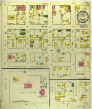
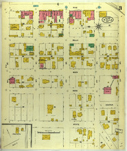
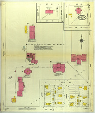
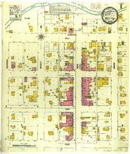
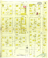
Rolla, Missouri, 1893 June, sheet 1 Image Rolla, Missouri, June 1893. Streets: Pine, Rolla, Main, College, Center, 9th (Ninth) Street, 8th (Eighth) Street, 7th (Seventh) Street, 6th (Sixth) Street, Missouri, School of Mines Member of Rolla, Missouri maps
Rolla, Missouri, 1905 September, sheet 2 Image Rolla, Missouri, September 1905. Streets: Elm, Pine, Rolla, Main, Park, 12th Street, 11th Street, 10th (Tenth) Street, 9th (Ninth) Street, Missouri, School of Mines Engineering Building Member of Rolla, Missouri maps
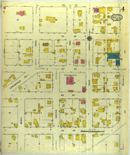
Rolla, Missouri, 1905 September, sheet 3 Image Rolla, Missouri, September 1905. Streets: Pine, Rolla, Main, Park, State, 9th (Ninth) Street, 8th (Eighth) Street, 7th (Seventh) Street, 6th (Sixth) Street, 5th (Fifth) Street, Center Member of Rolla, Missouri maps
Rolla, Missouri, 1917 June, sheet 2 Image Rolla, Missouri, June 1917. Streets: 3rd (Third) Street, 2nd (Second) Street, Main, Rolla, 12th Street, 11th Street, Main, Missouri, State School of Mines Member of Rolla, Missouri maps
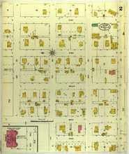
Rolla, Missouri, 1910 November, sheet 1 Image Rolla, Missouri, November 1910. Index; Streets: Oak, Elm, Pine, 12th Street, 11th Street, 10th (Tenth) Street, 9th (Ninth) Street Member of Rolla, Missouri maps
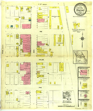
Rolla, Missouri, 1917 June, sheet 4 Image Rolla, Missouri, June 1917. Streets: 8th (Eighth) Street, 7th (Seventh) Street, 6th (Sixth) Street, 5th (Fifth) Street, 4th (Fourth) Street, Beech, Center, Main, Rolla, Springfield Road, State, Park Member of Rolla, Missouri maps
Rolla, Missouri, 1917 June, sheet 5 Image Rolla, Missouri, June 1917. Streets: Olive, Elm, Pine, Rolla, 9th (Ninth) Street, 8th (Eighth) Street, 7th (Seventh) Street, 6th (Sixth) Street, 5th (Fifth) Street, Oak Member of Rolla, Missouri maps
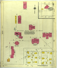
Rolla, Missouri, 1910 November, sheet 2 Image Rolla, Missouri, November 1910. Streets: 6th (Sixth) Street, 5th (Fifth) Street, 3rd (Third) Street, 2nd (Second) Street, Cedar, Walnut, Pine, Main, Rolla, 12th Street, 11th Street, Missouri, State School of Mines Member of Rolla, Missouri maps
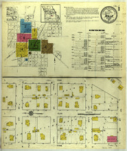
Rolla, Missouri, 1917 June, sheet 1 Image Rolla, Missouri, June 1917. Index; Streets: Oak, Elm, Pine, 12th Street, 11th Street, 10th (Tenth) Street, 9th (Ninth) Street Member of Rolla, Missouri maps
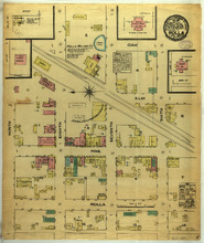
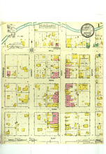
Rolla, Missouri, 1897 August, sheet 2 Image Rolla, Missouri, August 1897. Streets: Cedar, Olive, Oak, Elm, Pine, Ninth, Eighth, Seventh, Sixth, Fifth Member of Rolla, Missouri maps
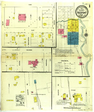
Rock Port, Missouri, 1900 July, sheet 1 Image Rock Port, Missouri, July 1900. Streets: Mill, Rock, Cass, Clay, Nebraska, Market, Main, Water Member of Rock Port, Missouri maps
Rock Port, Missouri, 1911 September, sheet 2 Image Rock Port, Missouri, September 1911. Streets: Mill, Rock, Cass, Clay, Nebraska, Market, Main, Water Member of Rock Port, Missouri maps
Rock Port, Missouri, 1893 March, sheet 1 Image Rock Port, Missouri, March 1893. Streets: Mill, Rock, Cass, Clay, Nebraska, Market, Main, Water Member of Rock Port, Missouri maps
Rock Port, Missouri, 1900 July, sheet 2 Image Rock Port, Missouri, July 1900. Streets: Clay, Calhoun, Cass, Bluff, Market, Main, Water, Court, Kansas, Nebraska, College, Washington Member of Rock Port, Missouri maps
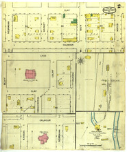
Rock Port, Missouri, 1893 March, sheet 2 Image Rock Port, Missouri, March 1893. Streets: Clay, Calhoun, Cass, Nebraska, Market, Main, Water, Bluff, Court, Kansas, Washington, Grieve and Grebe's Rock Port Steam Roller Mills Member of Rock Port, Missouri maps
Rock Port, Missouri, 1911 September, sheet 3 Image Rock Port, Missouri, September 1911. Streets: Clay, Calhoun, College, William, Nebraska, Market, Main, Grant, Water Member of Rock Port, Missouri maps
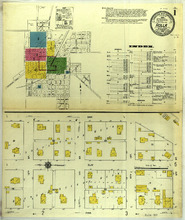
Rock Port, Missouri, 1911 September, sheet 1 Image Rock Port, Missouri, September 1911. Index; Streets: Cass, Clay, Calhoun, Bluff, Washington, Kansas, Court, Nebraska, County Road Member of Rock Port, Missouri maps
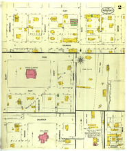
Ridgeway, Missouri, 1914 October Image Ridgeway, Missouri, October 1914. Streets: A Street, Vine, Poplar, Pine, Wood, Main Member of Ridgeway, Missouri maps