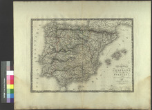
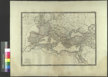
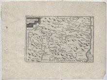
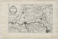
Asia Minor (1851)

Image
This is a steel engraved map of Asia Minor in 1851. It shows Cities, Towns, Rivers, Mountains, Lakes, and other features. John Tallis (1817–1876) was an English cartographic publisher. His company, John Tallis and Company, was in business in London from 1838 to 1851. Countries Shown on the map: Turkey, Greece, Cyprus, and Syria. Cities appearing on the map: Greece: Island of Scarpanto (Karpathos): Scarpanto (?), Avdemo (?), and Pt. Grado (?). Island of Rhodes: Kalavyah (Kattavia), M. Oros (?), Pyrgos (?), Lakanyah (Lachania), Lanathey (?), Polakah (Apolakkia), Skyanna (Siana), Phanes, Lindo (Lindos), Archangelo (Archangelos), Kalathease (Kalithies), and Rhodes. Island of Samos: Samos, Leka, and Courtotes (?). Island of Nicaria: Evthelo (Evdilos?). Island of Mytilene (Lesbos): Sigri, Liman (?), Arghena (?), Mytilene, and Scopelo (Skopelos). Island of Scio (Chios): Valisso (Volissos), Lethe (Lithi), and Kalamoti (Kalamoti). Cyprus: Stroumbi (Stroumpi), Baffa (Paphos), Carbouthi (?), Avdinio (Avdimou), Limesol (Limassol), Old Limesol (?), Pendasimo (?), Cormachitti (Kormakitis), Lapitho (Lapithos), Nicosia, Larnica (Larnaca), Cerina (?), Famagosta (Famagusta), Zdatilo (?), Amendra (?), Costro (?), and Haidar (?). Syria: Baneas (Baniyas), Jebili (Jableh), Ladikiyeh (Latakia), Serakheb (Saraqib), Emghir (?), Suriyeh (?), Herakleh (?), Rakkah (Al-Raqqah), Haji Wali (?), Toyhuk (?), Jinder Aba (?), Ak Deyavin (?), Tadef (Tedef), Meheritei (?), Hoilan (?), Aleppo, Carurabad (?), Safireh (As-Safira), and Sajur (?). Turkey: Davabourno (?), Vasilca (?), Boodroom (Bodrum), Melasso (Milas), Labrando (Labraunda), Heraclea (Herakleia), Demerjj Dere (?), Patinotiko (?), Samsoun (?), Scala Nuova (Kuşadası), Aiasaluck (Selçuk), Aidin Ghieuzel Hissar (Aydın), Claros, Cassab (Kasaba), Andiphilo (?), Suaret (?), Fornas (?), Patara, Yaloogie (?), Koonik (Kınık), Deuvar (?), Kousk (?), Ayvasil (?), Orahn (?), Makri (Fethiye), Oorloojah (?), Katra (?), Dollomon (Dalaman), Caunus (Kaunos), Keuygeeze (Köyceğiz), Olouboonar (?), Cagiolasolhucooe (?), Marmaras (Marmaris), Port Giova (Gökova), Moulinda (?), Almalee (Elmalı), Lekena (?), Yenibazar (Yenipazar), Chifteh Cafe (?), Nazeli (Nazilli), Arepas (?), Kuyuia (Kuyucak), Arrahchiflee (?), Kardsu (?), Yeerah (?), Cafe (?), Saraikieui (Sarayköy), Eski Hissar (?), Denizli, Yoomrhudas (?), Hoomarhoosarry (?), Pombuk Kaleli (Pamukkale), Chonas (?), Kaldele (?), Chardak (Çardak), Myra, Phineka (Finike), Artrasarny (Adrasan), Deliktash (?), Arycanda, Tekrova (Tekirova), Hameau (?), Adalia (Antalya), Laara (Now the District of Lara in Antalya), Bigikli (Bıyıklı), Stanisaw (?), Kara Punarkieui (?), Tshaltigshi (?), Allahsun (Ağlasun), Buldur (Burdur), Yazekieui (?), Isbarta (Isparta), Ketzi Borlou (Keçiborlu), Egerdir (Eğirdir), Kereli (Kireli), Bei Shehr (Beyşehir), Ptolemais (?), Alaya (Alanya), Silinty (?), Karadran (?), Chelindreh (Aydıncık), Selevke (Silifke), Mout (Mut), Ermenek, Sinana (?), Maiane (?), Karaman, Kizil Chesmeh (?), Ulisera (?), Cassaba (?), Chorla (?), Ak Chesha (Akçaşehir), Har Khan (?), Karabounar (Karapinar), Well (?), Well (?), Ismil (İsmil), Well (?), Elmasun (Güneysınır?), Katabothra (?), Isaura (Isauria), Kirogakieui (?), Koniyeh (Konya), Zillieh (?), Boghaz Kieui (?), Kara Bourja (?), Tris Maden (?), Kara Euran (Ortakaraören), Seidi Shehr (Seydişehir), Aufschar (?), Alan Buzuk (?), Eregli (Ereğli), Har Khan (?), Kayan (?), Bor, Nigdeh (Niğde), Kiz Hissar (?), Kolu Kushla (?), Ruined Khan (?), Guard Ho. (?), Barracks (?), Guard Ho. (?), Golek (Gülek), Mezarluk (?), Khan Vil (?), Vil (?), Adana, Ojivahli (?), Jakliguba (?), Sis, Yedezliy Kieui (?), Karasis (?), Pershendy (?), Lamas Vil. (?), Mezetli (Mezitli), Kara Hissar (?), Marsyn (Mersin), Koradouvar (?), Tarsus, Karadash Khan (Karataş), Misis (Mopsuestia), Kara Kapu (?), Ayas (Yumurtalık), Suadeiah (Samandağ), Kokson (Göksun), Belahlan (?), Marash (Kahramanmaraş), Dunkalat (?), Tartahli Koi (?), Kars (?), Urzin (?), Burnazsu (?), Yuzler (?), Boyas (?), Iskenderoon (İskenderun), Bogras (?), Sanamibli (?), Aliji (?), Aintab (Gaziantep), Arje (?), Port William (?), Eleisha (?), Andakia (Antakya), Diyar-Bekr (Diyarbakır), Severek (Siverek), Gergen Kaleh si (?), Hadro (?), Tornedah (?), Khantarah (?), Laro weran (?), Hoshun (?), Nahrlaga (?), Kerkunah (?), Oghegird (?), Somisat (?), Urfah (Şanlıurfa), Zibbili (?), Tel Jaffer (?), Tel Attchan (?), Harran, Kulleyuk (?), Arslan Tagh (?), Saruj (Suruç), Bireh jik (Birecik), Charmeli (?), Ruins (?), Adiyaman (Adıyaman), Pelvereh (Perre), Bur Konak (Börkenek), Besni, Haidli Bazar (?), Narsis (?), Zeklery Boser (?), New Troy (?), Old Troy (Troy), Alexandria (Alexandria Troas), Gura (Güre), Ichivna (?), Adraniytti (?), Sarkieup (?), Kareinkieui (Kareinkieui), Alvali (Ayvalık), Ayasmat (?), Kabakum, Pergamo (Bergama), Dekili Kieui (Dikili), Menimen (Menemen), Fouges (Phocaea), Smyrna, Vourla (Urla), Sahio (?), Murdovan (Mordoğan), Ritri (?), Latzaka (?), Soghajik (Seferihisar), Tourbali (Torbalı), Tyria (Tire), Bainder (Bayındır), Trianda (?), Ninfi (?), Cassaba (Turgutlu), Manisa, Ak Hissar (Akhisar), Kirkagatch (Kırkağaç), Bash Gelemba (?), Balikesri (Balıkesir), Umerkul (?), Meulver Kieui (?), Tash Kapou (Taşköprü), Kirmasli (?), Hdiz (?), Kefseut (?), Chiflik (?), Ahadj Hissar (?), Balat (?), Yeniji-kieui (?), Bogaditza (?), Singerli (?), Munyik (?), Ak Dagh (?), Assanler (Hasanlar), Kierkji (?), Selendi, Tefen (?), Kieui (?), Koula (Kula), Adala (?), Bin Tepeh (Bin Tepe), Sart (Sardis), Allah Sheher (Alaşehir), Aineh Ghieul (?), Sirghe (?), Aktash (?), Gueleri Kieui (?), Geuneh (Güney), Kelles (?), Debrent (?), Alamsalam (?), Bulladan (Buldan), Chindery (Cindere), Demirji-kieui (?), Seve-kieui (?), Yaessi-kieui (?), Alfachar (?), Ishekti (Çivril), Suleimanli (?), Canchas (?), Segicler (Selçikler), Sousous-kieui (Sousous), Yenisher Selendi (Yenişehir), Ushak (Uşak), Kieurkji (?), Gunenkieui (?), Yeni-kieui (Yenikent), Ghiediz (Gediz), Yeni-kieui (Gediz), Tchavdour (?), Chaji kieui (?), Gozuljah (?), Kargitash (?), Tauschanli (Tavşanlı), Mohimoul (?), Aineghuil (İnegöl), Turbeh (?), In Oghi (?), Eski Shehr (Eskişehir), Sarilar (Sarılar), Meulk (Mülkköy), Sevri Hissar (Sivrihisar), Sidi Ghazi (Seyitgazi), Kutahiyah (Kütahya), Taular (?), Altun Tash (Altıntaş), Morad Dagh (?), Usman(?), Alfiom Kara Hissar (Afyonkarahisar), Eski Kara Hissar (İscehisar?), Bolawadim (Bolvadin), Tshaktelu (?), Heraan Kaleh (?), Beiad (?), Geumek kieui (?), Hamza Hadji (?), Tchander (?), Germa, Bala Hissar (?), Barduklu (Bardakcı), Kara (?), Aslan (?), Sevin kieui (?), Saoran (?), Sandukli (Sandıklı), Deenair (Dinar), Olou Borlou (Uluborlu), Borlou (?), Yalobatch (Yalvaç?), Yeukler (?), Fn. of Midas (?), Arischar (?), Ak Hissar (?), Kani Aghatch (?), Ak Shehr (Akşehir), Arkut Khana (?), Pichankieui (?), Sarullas (?), Angora (Ankara), Yaila (?), Karghahli (Kargalı), Alif Ru (?), Kam Gedik (?), Juluk (?), Ingehsu (?), Hasan Oghlu (Hasanoğlan), Akserai (?), Sangor (?), Denek Madden (?), Banam (?), Karajiler (Karakeçili), Tol (?), Kurkli (Kırıklı), Kapa-keui (Köprüköy), Achmed (?), Sogher (?), Tash Kasman (Kaman), Kulu Kieui (Kulu), Arghun Kieui (?), Chukur Agha (?), Ilghun (Ilgın), Bedel Kaleb (?), Kadun Khaha (Kadınhanı), Ladik, Dedeler, Tuzla (?), Inya (?), In Avi (?), Iskil (Eskil), Sultan Khan (Sultanhanı), Adjem (?), Mousa Kouyou-su (?), Kodj Hissar (Şereflikoçhisar), Boghaz Kieui (Boğazköy), Sarai (?), Boghaz Kieui (Boğazkale), Nefezkieui (?), Yeuzgatt (Yozgat), Ingurly (?), Batal (?), Kislan (?), Kir Shehr (Kırşehir), Mujur (Mucur), Booslyan (Boğazlıyan), Aflok (?), Kurakum (?), Haji Kektash (Hacıbektaş), Yara-pason (?), Sari Karaman (Sarıkaraman), Taitor (?), Nenib Shehr (Nevşehir), Malagob (?), Ak Serai (Aksaray), Koyali (?), Helvar Dere (Helvadere), Sevri Hissar (Sivrihisar), Misli (?), Kara hissar (?), Ruined Khan (?), Develi, Injesu (İncesu), Kaisariyeh (Kayseri), Gomotch (?), Sultan Khan (?), Kalat Masman (?), Pallas (Palas), Sari Oghlan (Sarıoğlan), Gelermek (Gemerek), Arslan Toghmish (Arslandoğmuş), Zora (Zara), Yenijeh (Çimenyenice), Keimez (Dışkapı), Sivas, Aladja Khan (?), Kangol (Kangal), Derendah (Darende), Tanil (?), Manjutik (?), Gurum (Gürün), Karasaki (?), Chaherlasle (?), Tunuz (?), Abasilli (?), Setrek (?), Yenijah (?), Bostan (?), Sooey isury (?), Kara Kulak (?), Erzingan (Erzincan), Kemakh (Kemah), Hernemeh (?), Muselimo House (?), Devriki (?), Enden (?), Gemi Koi (?), Hoshmat (?), Palu, Egin (Kemaliye), Kharput (Elazığ), Kebban Maden (Keban), Arab-gir (Arapgir), Hakim Khan (Hekimhan), Tilkeh (?), Hogasur (Flooded by the creation of Lake Keban in 1974), Kizin (Gezin), Arghana Maden (Maden), Sardar Khan (?), Mezirah (?), Keumaur Khan (Kömürhan Bridge?), Fez Oglu (?), Gozeneh (Gözene), Sarghi (Sürgü), Malatia (Malatya), Arka (Akçadağ), Hassan Bedrik (?), Biga, Kazakti (?), Aidinjik (?), Erdek, Port Paillo (?), Ganos (Gaziköy), Kavatch (Kavakköy), Dunatika (?), Kamares (Kemer), Lampsacus (Lapseki), Burgas (?), Kippis Bouroun (Kepez), Abydos, Cas. of Europe (?), Bovalli Kallesci (?), Gallipoli, Enos (Enez), Agweh (Ağva), Mesjid Keui (?), Chileh (?), Ft. Kilios (?), Castles of Europe & Asian (Rumelihisarı and Anadoluhisarı), Pera (Now the district of Beyoğlu in Istanbul), Constantinople (Istanbul), Kntchuk Tchekmedje (Now the district of Küçükçekmece in Istanbul), Buyuk Tchekniedje (Now the district of Büyükçekmece in Istanbul), Silivri, Scutari (Now the district of Üsküdar in Istanbul), Fener Bagtche (Now the neighborhood of Fenerbahçe in Istanbul), Tuzla Kieui (Tuzla), Jarimdji (?), Izmid (İzmit), Dagirmon (?), Karamusal (Karamürsel), Ersek (Hersek), Bazarkiui (?), Iznik (İznik), Brusa (Bursa), Tartali (Tahtalı), Moudaniah (Mudanya), Yeniji Kieui (Yenikaraağaç), Ulubad (Uluabat), Karaoglankieu (Karaoğlan), Deblekieui (?), Zunguldaik (Zonguldak), Kara Bunar (Karapınar), Eregli (Karadeniz Ereğli), Pershembah (?), Shaurak (?), Alabli (Alaplı), Ak Kaya Kieui (Akkaya), Bayani (?), Akehah Shehr (?), Uskub (?), Duzchah (Düzce), Boli (Bolu), Tchagi (?), Milankaui (Melenağızı), Darikeui (Darıçayırı), Scheraf (?), Kerken Adasi (Kefken), Bahna (?), Ada Bazar (?), Khandak (?), Yarbasan (?), Armascha (?), Sabaniah (Sapanca), Kiwa (?), Terekli (Taraklı), Lefke (Osmaneli), Shughut (?), Kestabet (?), Nali Khan (Nallıhan), Kotchuk Kieui (?), Kalaijik (Kalecik), Akja Tash (?), Yayli (?), Akgharan (?), Kankiri (Çankırı), Olajik (?), Karaja Wiran (?), Tunai (?), Mironos (?), Arandi (?), Jighes (?), Eukban Aghiran (?), Jigher (?), Sahlun (?), Tcherkes (Çerkeş), Istanos (?), Kerede (Gerede), Hamanli (Hamamlı), Kastamuni (Kastamonu), Daurikan (?), Bakir Kureh si (Küre?), Chergora (?), Osmanziki (?), Bedil, Ayyanof Chilam (?), Araba Chila (?), Kara Binar (?), Zafaran Boli (Safranbolu), Naghzar (?), Dursanli (?), Ormah (?), Makin (?), Aramlah (?), Charmanli kieui (?), Filiyas (Filyos), Kizil Elmah (Kızılelma), Bartan (Bartın), Murad Bey (Muratbey), Amasserah (Amasra), Delikli Chileh (?), Kidros (?), Chideh (Cide), Uln Kereme (?), Fakoz (?), Meset (?), Kar Yani (?), Zarpana (Özlüce?), Ineboli (İnebolu), Ereni (?), Amasia (Amasya), Cauvsa (Havza?), Vizir Keuprr (Vezirköprü), Hadji Kieui (?), Aurhat Kieui (?), Khojanlik (?), Alajah (Alaca), Euyuk (Alaca Höyük), Tekiyeh Hatap (Çayhatap), Tchorum (Çorum), Mujteli (?), Osmanjik (Osmancık), Soungourli (Sungurlu), Chayan Kieui (?), Bayad (Bayat), Kurshal (?), Chai Kiui (?), Iskelib (İskilip), Tosia (Tosya), Korghi (Kargı), Durgan (?), Yuruk Yaylisi (?), Tash Kupri (Taşköprü), Iwalli (?), Arana (Abana), Stefanos (?), Kaza Kildi (Kazakyalisi?), Kaniza Kieui (?), Mehmet Bey (?), Boiavad (Boyabat), Amsoros (Amsoros Point?), Sinope (Sinop), Chobanlar (?), Gherseh (Gerze), Kousoufetova (?), Alatcham (Alaçam), Bafra, Douraan (Durağan), Chua (?), Cheltik (Çeltek), Omanagh Agbatsh (?), Isberde (?), Mellen (Mesudiye?), Isskassar (?), Bashichiflik (Başçiftlik), Ordu, Fatsa, Niksar, Denekse (?), Kuchuk Kouera (?), Herek (?), Kizil Chiflik (?), Gumenek Keupri (?), Tocat (Tokat), Boghaz Hissan Kaleh (?), Eamich (?), Thermeh (Terme), Tumulus (?), Korevli (?), Zilleh (Zile), Tourkhal (Turhal), Ladik, Charshambah (Çarşamba), Samsun, Kuru Balur (?), Koumjaas (?), Baibut (Bayburt), Balahor (?), Kerkit Chiftlik (?), Uleh Sheivan (?), Kara Hissar (Şebinkarahisar?), Kulei Hissar (?), Gumishkhana (Gümüşhane), Kerasun (Giresun), Tireboli (Tirebolu), Trebisonde (Trabzon), Givislik (?), Karakaban (Karakaban Dagi), Yanboli (?), and Kulensah (?).

Carte Generale De Espagne es du Portugal Par A. H. Brue, Geographe de S. A. R. Mousieuv. (1821)

Image
This is a copper engraved map of Spain and Portugal from 1821 by Adrien Hubert Brue. The title of the map is Carte generale de l'Espagne en du Portugal, par A.H. Brue, Geographe de S.A.R. Monsieur. A Paris, Chez l'Auteur, rue des Macons-Sorbonne, no. 9, et chez les principaux marchands de geographie. Decembre 1821. This roughly translates to General Map of Spain and Portugal, by A. H. Brue, Geographe S. A. R. sir. In Paris at Rue des Macons-Sorbonne, No. 9 and at major geography merchants. December 1821. Countries appearing on this map: Morocco, Spain, Great Britain, Portugal, Cities appearing on this map: Morocco: Arsila (Asilah), Tanger (Tangier), Tetuan (Tétouan), Spain: Autonomous City of Cueta: Cueta. Andalusia: Province of Huelva: Te. la Higuera (?), Province of Cádiz: Ceuta, Salinas (?), Chipiona, Rota, San Lucar (Sanlúcar de Barrameda), Bornos, Arcos (Arcos de la Frontera), Xeres (Jerez de la Frontera), Pto. de Sa. Maria (El Puerto de Santa María), Pto. Real (Puerto Real), Paterna (Paterna de Rivera), Alcala (Alcalá de los Gazules), Medinasidonia (Medina-Sidonia), Chiclana (Chiclana de la Frontera), Renalia (?), Conil (Conil de la Frontera), S. Carlos (?), Cadix (Cádiz), Te. Bernuja (?), Veger (Vejer de la Frontera), C. de Plata (?), Tarifa, Algeciras, S. Roque (San Roque), Ximena (Jimena de la Frontera), Ubrique, Setenil (Setenil de las Bodegas), Pta. Serrano (Puerto Serrano), Grasalema (Grazalema), Province of Seville: las Cabezas (Las Cabezas de San Juan), Te. de Oreas (?), Lebrija, la Real Ca. del Cuervo (El Cuervo de Sevilla), Pruna, Province of Málaga: Gaucin (Gaucín), Estepona, Marbella, Te. de Cala Moral (?), Co. Licata (?), Coin (Coín), Alhaurin (Alhaurín el Grande), Monda, Turon (?), Ronda, Alora (Álora), Te. de Cala Moral (La Cala de Mijas), Te. Frangerola (Fuengirola), Te. Molinos (Torremolinos), Almogia (Almogía), Malaga (Málaga), Velez Malaga (Vélez-Málaga), Pinos del Rey (?), Torros (Torrox), Province of Granada: Almunecar (Almuñécar), Salobrena (Salobreña), Motril, Velez (Vélez de Benaudalla), Lanjaron (Lanjarón), Orgiva (Órgiva), Torbiscon (Torvizcón), Gualchos, Ce. de Rabida (La Rábita), Busqotar (Busquístar), Ugijar (Ugíjar), Province of Almería: Adra, Berja, Ce. de Guardas Viejas (Castillo de Guardias Viejas/Los Baños de Guardias Viejas/Guardias Viejas), Dalias (Dalías), Almeria (Almería), Rioja, Nijar (Níjar/San Isidro de Níjar)), Te. S. Miguel (San Miguel de Cabo de Gata), Te. de Calafiguera (?), Great Britain: Gibraltar: Gibraltar Portugal: Algarve Region: Faro District: N. Sa. de la Luz (Praia da Luz), Carrapateira, Aljesur (Aljezur), Seixe (Odeceixe), Monchique, Alentejo Region: Beja District: Serdao (Cavaleiro), Villanova de Milfontes (Vila Nova de Milfontes), Setúbal District: Sines,

Asia (1843)

Image
Steel engraved map of Asia by Thomas Kelly. Countries appearing on the map: Indonesia, India, Ceylon (Sri Lanka), Thailand, Malaysia, Philippines, Saudi Arabia, Yemen, Oman, Myanmar, Vietnam, China, Jordan, Kuwait, United Arab Emirates, Iran, Pakistan, Nepal, Bangladesh, Taiwan, Turkey, Syria, Israel, Iraq, Turkmenistan, Afghanistan, Tajikistan, Uzbekistan, South Korea, Japan, Russia, Georgia, Azerbaijan, Kazakhstan, Mongolia, North Korea, . Cities appearing on the map: Indonesia: Island of Sumatra: Padang, Manjatta (?), Bencoolen (Bengkulu), Liman (?), Natal, Tappanooly (Tapanuli), and Acheen (Banda Aceh). Island of Borneo: Succadana (Sukadana), Banjar Massir (Banjarmasin), Itabier (?), Sambas, Lava (?), and Barvongan (?). Island of Celebes: Waya (?) and Boot (?). India: Cochin (Kochi), Tanjore (Thanjavur), Pondicherry, Calicut (Kozhikode), Mysore, Seringapatam (Srirangapatna), Mangalore, Bednoor (Nagara), Arcot, Bolhari (?), Canoul (?), Onore (Honnavar), Goa, Vingorla (?), Daboul (?), Bombay (Mumbai), Poonah (Pune), Visiapoor (Vijayapura), Madras (Chennai), Nellore, Masulipatan (Machilipatnam), Cicacole (Srikakulam), Gumsoor (?), Pour Bunder (Porbandar), Aurangabad, Surat, Cambay (Khambhat), Burhampoor (Burhanpur), Ahmedabad, Ougein (?), Pattan (Patan), Ajimere (Ajmer), Nagore (Nagaur), Jesslemere (Jaisalmer), Agra, Matra (Mathura), Hissar (Hisar City), Delhi, Nagpoor (Nagpur), Ruttenpour (Ratanpur), Allahabad, Benares (Varanasi), Cuttack, Calcutta (Kolkata), Hoogly (Chinsurah), Moorshedabad (Murshidabad), Almora, Ghergonge (?), Leh, Cashmere (Kashmir region), and Nagal (?). Ceylon (Sri Lanka): Candi (Kandy) and Trincomalay (Trincomalee). Thailand: Papera, Cini (?), Siam (Ayutthaya), Ogmo (?), and Zemee (Chiang Mai). Malaysia: Queda (Kedah), Pahang, Malacca, Sedang (?), Barrulo, Borneo (Bandar Seri Begawan), and Abia (?). Philippines: Mindanao, Tandag (Tandang), Tambove (?), Bigan (Vigan), Manilla (Manila), and Duillican (?). Saudi Arabia: Confodah (Al Qunfudhah), Attuie (?), Ghezan (Jizan), Midian (?), Acra (?), Abou Jhee (?), Kalais Clarega (?), Medina, Yambo (Yanbu), Rabac, Juddah (Jeddah), Mecca, Tangia (?), Kariatain (?), Deraie (?), Anizeh (?), Tima (?), Kin (?), Daumat (Dumat Al-Jandal), Shakra (Shaqraa), Faraha (?), Lahsa (Al-Hasa), and El Katif (?). Yemen: Chamir (Khamir), Loheia (Al Luḩayyah), Sana (Sana'a), Hodeida (Al Hudaydah), Mocha, Aden, Mareb (Ma'rib), Mouab (?), Shahar (Ash Shahar), and Doan (?). Oman: Hasec (Hasik), Ainad (?), Harmin (?), Sohar, Sikki (?), Muscat, Masera (?), and Dsjau (?). Myanmar: Loongee (?), Persaini (?), Rangoon (Yangon), Martaban (Mottama), Tavay (Dawei), Ramedhayn (?), Aracan (Located in Modern Rakhine State, possibly Sittwe?), Ummerapoora (Amarapura), and Quangtong (?). Vietnam: Saigon (Ho Chi Minh City), Nhiatrang (Nha Trang), Quinhone (Qui Nhơn), Huefoo (Huế), Sinhoa (?), Kosho (?), Ketos (?), and Caihoa (?). China: Tankien (?), Louitcheou (?), Macao (Macau), Tcharor (?), Lassa (Lhasa), Chamka (?), Pa (?), Nanngin (Nanning), Quangnan (?), Yucnkiang (?), Yunnan (Kunming), Quansi (?), Tongchuen (Tongchuen), Kiensee (?), Oumongtou (?), Coking (?), Kynynen (?), Setcheou (?), Tchintcheou (?), Pongchoui (?), Yongtcheou (?), Pinglo (?), Canton (Guangzhou), Nanyong (?), Hinghoa (?), Kantchoou (?), Ningan (?), Kicutchang (?), Yatcheou (?), Tchucheou (?), Karakish (?), Karia (?), Kheimlig (?), Peim (?), Jemlah (?), Conthooudsong (?), Chaupaton (?), Cocosai (?), Itcha (?), Ike (?), Out (?), Tchanki (?), Van (?), Koeitcheou (?), Fang (?), Hantchong (Hanzhong), Singan (Xi'an), Oei (?), Li (?), Lingtao (?), Pangloso (?), Mitchi (?), Tchingtou (?), Longgan (?), Chansang (?), Hangtcheou (Hangzhou), Nanking (Nanjing), Kaitcheou (?), Koung (?), Nanyang, Kouett (?), Honan (Province of Henan), Ytcheou (?), Tchintcheou (?), Tongchang (?), Pinyang (Linfen), Taiyuen (Taiyuan), Tiensing (Tianjin), Peking (Beijing), Taitcheou, Korga (Khorgas), Cashgar, Manas, Tarfan (Turpan), Aktas (?), Hotocossa (?), Soroto (?), Chatcheou (?), Ouerlo (?), Chaomamg (?), Pilotau (?), Zouroukaitou (?), Tchahan (?), Charot (?), Zhehol (Chengde), Kaltagher (?), Maomingan (?), Saghalien Oula Hotun (?), Merguen-hotun (?), Tsitchicar (?), Tchalei (Tchalei), Petoune (?), Sarhou (?), Nimgoula (?), Kirmoula (?), Chinyang (Shenyang), and Kaitcheou (?). Jordan: Akaba (Aqaba) and Amman. Kuwait: Grane (Kuwait City). United Arab Emitares: Kalba (?) and Mascalet. Iran: Shiraz, Busheer (Bushehr), Ruins of Persepolis, Lar, Mastih (?), Gombroon (Bandar Abbas), Minau (?), Killeck (?), Tabriz, Hamadan, Nehavrend (Nahavand), Basano (?), Mesghed (?), Esterabad (Gorgan), Sabsivar (Sabzevar), Foocheng, Tahiran, Amol, Koum, Ardistan, Samadji, Salan, Asopas, Istakar, and Ispahan. Pakistan: Penjpour (?), Dizek (?), Siveh (?), Ermajil (?), Haur (?), Arbis (?), Kandabil (Jhal Magsi), Kosdi (?), Tatta (Thatta), Bakar (?), Behawelpoor (Bahawalpur), Vaehend (?), Pusheng (?), Maroo (?), Moultan (Multan), Attock, and Lahore. Nepal: Khatmandu (Kathmandu), Goarkha (?), and Jemlah (Supposedly in Western Nepal). Bangladesh: Dacca (Dhaka) and Islamabad (Chittagong). Taiwan: Taiwan (Tainan) and Qudon (?). Turkey: Brusa (Bursa), Adramytta (Edremit), Smyrna (İzmir), Scala nova (Kuşadası), Marmorice (Marmaris), Angora (Ankara), Medan (?), Bostan (?), Konieh (Konya), Sconderoon (İskenderun), Diarbekir (Diyarbakır), Constantinople (Istanbul), Ismit (İzmit), Erekli (Karadeniz Ereğli), Sinope (Sinop), Louri (?), Trebizonde (Trabzon), Syria: Aleppo, Hems (Homs), Damascus, and Leja (Region of Lajat). Israel: Acra (Acre) and Jerusalem. Iraq: Mosul, Tekrat (Tikrit), Bagdad (Baghdad), Babylon, and Bassora (Basra). Turkmenistan: Ashor (?) and Amul (Türkmenabat). Afghanistan: Zarang (Zaranj), Herat, Candahar (Kandahar), Caubul (Kabul), and Balk (Balkh). Tajikistan: Badakshan (Region in both Afghanistan and Tajikistan), Kollan (?), and Cogend (Khujand). Uzbekistan: Bokhara (Bukhara), Koptchok (?), Khieva (Khiva), Tashkund (Tashkent), Andegan (Andijan), and Kaynk (?). South Korea: Kingkitao (Seoul?), Sanpou (?), and Coufou (?). Japan: Nagasaki, Kokura, Jeddo (Tokyo), Gisma (?), Shanday (?), Matsmay (Matsumae), and Sangar (Tsugaru). Russia: Azov, Atchuey (?), Askary (?), Archangel (Arkhangelsk), Stavropole (?), Taritzin (?), Astrachan (Astrakhan), Stavrople (Stavropol), Alandrovsk (?), Derbent, Marninski (?), Iskarski (?), Nervoski (?), Alimya (?), Virkhotouriye (Verkhoturye), Alapayov (Alapayevsk), Ecatterinburg (Yekaterinburg), Birsk, Oufa (Ufa), Sterlitomansk (Sterlitamak), Orenburg, Obdorsk (Salekhard), Pittarski (?), Voikoski (?), Beresov (?), Kodinskoi (?), Trouskoe (?), Repatovskoe (?), Tobolsk, Tiume (Tyumen), Issim (Ishim), Kourgan (Kurgan), Troitsk, Tyniskaya (?), Surgutoi (Surgut), Pirtchina (?), Tara, Omsk, Caynsk (?), Soumy (?), Sdorovskoie (?), Khatanskoie (?), Narym, Tomsk, Kholhyvan (?), Barnaule (Barnaul), Camen (Kamen-na-Obi), Biysk, Belochan (?), Avamska (?), Chorikha (?), Tchoumskaya (?), Inbatskoe (?), Yenisei (Yeniseysk), Krosnoyorsk (Krasnoyarsk), Oudinsk (?), Sayansk, Khotanskoie (?), Iurieva (?), Tchadobska (?), Covinska (?), Bineicava (?), Ykarova (?), Kirensk, Bourskikli (?), Irkoutsk (Irkutsk), Bargousin (Barguzin), Upr. Oudinsk (Ulan-Ude), Selenginsk (Novoselenginsk), Olensk (Ust-Olenyok), Dolganova (?), Colican (?), Corolcoya (?), Nuiskoi (?), Peghina (?), Vitunskaya (?), Koularska (?), Nertchinsk (Nerchinsk), Gighansk (Zhigansk), Yakoutsk (Yakutsk), Olekminsk (Olyokminsk), Yasca (?), Outaoussanmoudan (?), Ust Yansk (Ust-Yansk), Verkhotanskoi (Verkhoyansk), Aldan, Ust Mayo (?), Uda (Uda River), Kalar (?), Toun (?), Tondon Cajan (?), Novo (?), Pijm (?), Tchoulgue (?), Fourda (?), Zachiversk (?), Irbas (?), Yschoudskoi (?), Ochotsk (Okhotsk), Covimskoi (?), Upr. Covimskoi (?), Igighinsk (?), Zamskoi (?), Gavenki (?), Kortchina (?), Kamtschatka (Ust-Kamchatsk), Kiskina (?), Bolcherdsk (Ust-Bolsheretsk), Upper Kamtschatka (?), and Awatska B. or Port S. Peter & S. Paul (Petropavlovsk-Kamchatsky). Georgia: Kopi (?), Poti, and Teflis (Tbilisi). Azerbaijan: Backou (Baku). Kazakhstan: Ouralsk (Oral), Koletinor (?), Lokman (?), Turkistan, Tankat (?), Lebiagei (?), and Semipalatine (Semey). Mongolia: Karakum/Holin (Kharkhorin), Pombatu (?), Tchagan (?), and Parahotun (?). North Korea: Tchang tcham (?), Peitching (?), and Sichoui (?).

Typvs Frisiae Orientalis [jmp2015i0010]

Image
Cities appearing on this map: Germany: Lower Saxony: Varel, Dangast, Ellens (?), Amelant (?), Iarrichave (?), Steenhusen (?), Bokeren (Bockhorn), Driver (Driefel), Nieuborg (Neuenburgerfeld)?, Zetel, Arne (?), Sande, Marienhusen (?), Marien Zyl (Mariensiel?), Roshusen (?), Niend (Ancient church parish of Neuende), Schar (Now Schaar district of Wilhelmshaven), Sibeltzborch (Wilhelmshaven/Siebethsburg Castle), Heppens (Ancient church parish of Heppens/Wilhelmshaven City District of Heppens), Veher (?), Accum (Accumersiel), Knipens (Ancient Kniphausen/Knyphausen?), Feddewert (Fedderwarden/Fedderwardergroden), Inhusen (Ancient Inhausen), Knip Zyl (?), Tidevelt (?), Ottens (?), Sengwert (Sengwarden), Inhuser Zyl (Inhausersieler Street near Bohnenburg), Digitized 2-2015

Partie Meridionale De La Russie D'Europe [jmap035]

Image
Countries appearing on this map: Turkey, Bulgaria, Armenia, Azerbaijan, Georgia, Russia Cities appearing on this map: Turkey: Constantinople (Istanbul), Ardanouji (Ardahan?), and Kars. Bulgaria: Bourgas (Burgas). Armenia: Ouzoumlar (?) and Agdjakala (?). Azerbaijan: Ganja, Alapo (?), Konda (?), Scheki (Shaki), Schamachie (Shamakhi), Bakou (Baku), Eschmie (?), Biatlokan (Balakən), Kilvar (?), Kouba (Quba), Karadjami (?), Arablar (?), Georgia: Batoun (Batumi), Alambari, Akhaltzickh (Akhaltsikhe), Tcheri (?), Mismedhna (?), Kveschi (?), Gori, Tzchet (Mtskheta?), Douschet (Dusheti), Tiflis (Tbilisi), Signag (Sighnaghi), Telav (Telavi), Russia: Dagestan: Achti (?), Koura (Kurakh),

Carte De L'Empire Romain Sous Constantin, par A. H. Brue Geographe de S. A. R. Monsieuv. (1822)

Image
This is a copper engraved map of Europe from 1822 by Adrien Hubert Brue. The title of the map is Carte generale de l'Empire Romain sous Constantin, par A.H. Brue, Geographe de S.A.R. Monsieur. A Paris, Chez l'Auteur, rue des Macons-Sorbonne, no. 9, et chez les principaux marchands de geographie. Janvier 1822. This roughly translates to General Map of the Roman Empire under Constantine, by A. H. Brue, Geographe S. A. R. sir. In Paris at Rue des Macons-Sorbonne, No. 9 and at major geography merchants. January 1822. Constantine the Great (272-337) was the Emperor of Rome from 306-337. Countries appearing on this map: Egypt, Saudi Arabia, Libya, Jordan, Morocco, Algeria, Cities appearing on this map: Egypt: Apollinopolis Magna (Edfu), Syene (Aswan), Ombos (Naqada), Cataraetes (?), Pseleis (?), Berenice (Berenice Troglodytica abandoned in the 6th century), Hammon (?), Oasis Magna (Kharga Oasis), Latopolis (Esna), Hermunthis (Hermonthis), Thebae (Thebes, abandoned in the 1st Century), Apollinopolis Parva (Qus), Coptos (Qift), Tentyris (Dendera), Myosormos (Myos Hormos, abandoned after the 4th Century), Diospolis Parva (Hu), Abydus (Abydos, abandoned sometime after the 4th Century BC), Ptolemais (?), Chemmis vel Panopolis (Akhmim), Antaeopolis (Tjebu), Hypselis, Antinoe p. Besa (?), Hermopolis Magna (Hermopolis, abandoned sometime after the 3rd Century), Oasis Parva (Bahariya Oasis), Hepta (?), Oxyrynchus, Heracleopolis (Heracleopolis Magna, abandoned around 390), Arsinoe (Faiyum), Memphis (Abandoned in the 7th Century), Nomis (?), Aphroditopolis (Atfih), Clysma, Phaenicon (?), Pharan (Wadi Feiran), Apis, Paraetonium (Mersa Matruh), Derris extrema (?), Leucas Ptus. (?), Mareotis Lacus (Lake Mariout), Plinthinetes Sinus (Bay of Plinthine), Alexandria, Canopus (Abandoned sometime after 138 AD), Bolbitrium Ot. (Ancient Bolbitine Branch of the Nile), Bolbitine (Rosetta), Sais (Abandoned sometime after 525 BC), Sebennytus (Sebennytos which was abandoned sometime after the 3rd Century BC), Phatmeticum Ost. (Ancient Phatnitic branch of the Nile), Athribis (Abandoned sometime after the 4th Century AD), Heliopolis (Abandoned after the 6th Century AD), Bubastus (Bubastis which was abandoned after 449 AD), Heroopolis (Pithom which was abandoned sometime after the Roman era), Daphnes (?), Taphis (Abandoned sometime after 14 AD), Plusitum (?), Saudi Arabia: Iatrippa (Medina), Iambia (Yanbu), Madiana (?), Leuce (?), Phaemicon (?), Thumata (?), Magusa (?), Thaema (?), Negra (?), Libya: Garama (Germa), Augila (Awjila), Cydamus (Ghadames), Sabrata (Sabratha), Macomades Syrtis (?), Euphrantas Turris (?), Aspis Ptus. (?), Tubactis (?), Gerisa (Abandoned by the 11th Century), Oea vel Occa (Tripoli), Leptis Magna (Abandoned in the 7th Century), Darnis (Derna), Apollonia (Abandoned after 643), Cyrene (Abandoned in the 4th Century), Aplungis (?), Ptolemais (Abandoned in the 7th Century), Tauchira (Tocra), Hadriane (Deriana), Berenice (Benghazi), Axylis (?), Jordan: Aelana (Aqaba), Asiongaber (Ezion-Geber), Morocco: Adele (?), Cillaba (?), Fez, Volubilis (Abandoned by the 11th Century), Tremuli (?), Babba (?), Banasa (Iulia Valentia Banasa, abandoned around 285), Thamusida (Abandoned around 285), Sala (Chellah, abandoned in 1154), Exploratio ad Mercurium (?), Herpis (?), Algeria: Calaa (?), Mazices (?), Musalani (?), Desena (?), Vescerita vel Vescether (?), Tabudis (?), Tunisia: Pisida (?), Praesidium (?), Temp (?), Tacape (Gabès), Agiue Tu. (?), Thenae (Sfax), Taphrura (Sfax), Bizacina (?), Septimunica (?), Capsa (Gafsa), Telepte vel Tala (Thélepte), Tisurus (Tozeur), Libya Palus (?), Nepte (Nefta), Cyprus: Paphos,

Comitatus Namurci (1702)

Image
This is a highly detailed copper engraved map of the area around Namur, Belgium. There is a mileage cartouche and a title cartouche. This is from the publication, Atlas portatif, ou, le nouveau theatre de la guerre en Europe: contenant les cartes geographiques, avec les plans des villas & fortresses les plus exposees aux revolutions presented: accompagne d'une nouvelle methode pour apprendre facilement la geographie & la chronologie des potentats. A Amsterdam Chez Daniel de la Feuille 1702, which roughly translates in English to, Portable Atlas, or, The New Theatre of War in Europe Containing Geographical Maps, with City Plans and Fortress Plans which are most Exposed to the Revolution Presented: Accompanied by a New Method to Easily Learn Geography and Chronology. In Amsterdam by Chez Daniel de la Feuille in 1702. The title of the map is Comitatus Namurci La Feuille excudit which roughly translates to County Namur Printed by La Feuille. Daniel de La Feuille lived from 1640 until 1709. He was from Sedan in Northern France and was born to Huguenot parents. In 1683, he and his family fled religious persecution to Amsterdam and became an engraver and cartographer. Cities appearing in the map: Belgium: Liège: Eynges (Engis), Floen (Flône), Aymoin (?), Herion (?), Fisfontaine (Fize-Fontaine), Ouhe (?), Vignamot (?), Feumal (Fumal), Falays (Fallais), Coutuin (?), Hosdain (Hosdent?), Breft (?), Mox (Moxhe), Aum (?), Crehe (Crehen), Haesche (Hannêche), Acache, Emptines, Messle, Ambesmeau, Chiple, Mouha, Coutuin, Han, Mozey, Haesche (Hannêche), Acache (Acosse), Meffle (Meeffe), Ambesmeau (Ambrésinaux), Chiple (?), Mouha (Moha), Coutuin (?), Han (?), Mozey (?), Namur: Braehan (Branchon), Fraquees (Franquenée), Tauiers (Taviers), Hettemot (?), Asche en refail (Aische-en-Refail), Gemblours (Gembloux), Conroy (Corroy-le-Château), Aurenault, Sombreff (Sombreffe), Ligny, Boegne (Boignée), Bagny (?), Mons (?), Hauere (?), Boety (Bothey), Tongre (Tongrinne), S. Martin (Saint-Martin), Masy (Mazy), Visne, Argenti (?), Meux, Fero (Ferooz), Tillon (?), Du (Dhuy), Liernu, Osltn (?), Mehaigne (Mehaigne/Noville-sur-Mehaigne), S. Denis (Saint-Denis-Bovesse), Esmynes (Émines), Chemen (?), Rime (?), Haule (?), Name (Namur), Le Faliec (?), Bernacome (?), Ponthy (?), Frize (?), Leuze, Dassoulx (?), Ypigney (Upigny), Franeqwarat (Franc-Waret), Fernemons (Fernelmont), Haure (?), Froncou (?), Nouille sur Mehaig (Noville-sur-Mehaigne), Boneff ab. (Boneffe/Boneffe Abbey), Recourt (?), Hambruie (Hambraine), Vodon (Cortil-Wodon), Emptines (Hemptinne), Forte Iles (?), Arz (?), Selles (Seilles), Malroy (?), Hingeon, Sosoy (?), Som (?), Naesche (Namêche), Ielhusee (?), Bonen (Boninne), Marche (Marche-les-Dames), Bez (Beez), Yanau (?), Florisont (Floreffe/Floriffoux), Iodion (Jodion), Templo (Temploux), Ymedame (?), Monslier (Moustier-sur-Sambre), Spy, Omme (?), Faume (?), Iemepye (Jemeppe-sur-Sambre), Tarsen (Tarcienne), Hansen (Hanzinne), Bersee (Berzée), Leneff (Laneffe), Thille Chast. (Thy-le-Château), Puy (?), Iardinet Abb. (?) Castre (Chastrès), Walcourt, Vogne (Vogenée), Yue (Yves-Gomezée), S. Aubain (Saint-Aubin), Dacheu (?), Iamuelle (Jamiolle), Viller Y Eglise (?), Philippeville, S. Zelle (?), Sauton (Sautour), Iamaigne (Jamagne), Waudesy (Vodecée), Franhimont (Franchimont), Louten (Lautenne), Hastiers (Hastière/Hastière-Lavaux/Hastière-par-delà), Wassers abb. (?), Poren (?), Minaoye (Miavoye), Maure (Maurenne), Frayers (Castle of Freÿr), Ierenne (?), Ante (Anthée), Moruille (Morville), Rosoy (Rosée), Florennes, Corenne, Forge (?), Walloon Brabant: Perwez, Threbaex (?), Gonensau (?), Pandese (?), Courtil (Cortil-Noirmont), Gemlines (Gentinnes), Viller (Villers-la-Ville), Houtham (?), Nivelle (Nivelles), Marbais, Hainaut: Petit Reulx (Petit-Rœulx-lez-Braine), Selle (Pont-à-Celles), Busee (Buzet), Renez (Rèves), Frane (Frasnes-lez-Gosselies), Liberche (Liberchies), Lut (Luttre), Brunehault (There is a street Chaussee Brunehault), Ville Paroy (?), Melle (Mellet), S. Amand (Saint-Amand), S. Bris (Brye), Wagny (Wangenies), Wauferche (Wanfercée-Baulet), Banley (?), Farse (Farciennes), Flerso (Fleurus), Telon (?), Chastelniau (Châtelineau), Charleroy (Charleroi), Gilly, Soreamol (Soleilmont), Heppenyes (Heppignies), Wagnelle (Wagnelée), Hegne (?), Gosseliers (Gosselies), Vinille (?), Plouy (?), Sartles moisni (Sartis), le Ron (?), Fonteineleuesque (Fontaine-l'Évêque), Marchien au pont (?), Gamigno (?), Court (?), Chastillan (Castillon), Cense (?), Bossu (?), Forge (?), Senlry (?), Conille (?), Acos (Acoz), Marcinelle (?), S. Nicolas (Sart Saint-Nicolas), Nalen (?), Gerpines (Gerpinnes), France: Alsace-Champagne-Ardenne-Lorraine: Ardennes: Charlemont (Charlemont fortress in Givet)

Central America and the West Indian Islands (1863)

Image
This is a highly detailed copper engraved map of Central America and the West Indies published in 1863. This was created by A. K. Johnston for his book entitled, School Atlas of General & Descriptive Geography which was published by William Blackwood & Sons. Alexander Keith Johnston was a Scottish Geographer who lived from 1804 to 1871. This map has a section along with the title which states: Central America and the West Indian Islands, A. K. Johnston, F. R. S. E., Scale: 200 miles to an inch, 14,000,000 of nature, Scale of English Miles, The West Indian Islands are sometimes denominated the "Columbian Archipelago" or "The Antilles." In some English Charts the term "Leeward Isles", is erroneously applied to those of the Caribbean Group extending from Porto Rico to Dominica, those from Martinique to Tobago, being styled the "Windward Isles.", Railways, (B.)-British, (Da.)-Danish, (DU.)-Dutch, (F.)-French, (S.)-Spanish, (Sw.)-Swedish. Around the edge of the map reads: General Geography, Plate 25, William Blackwood & Sons, Edinburgh & London. Countries appearing on the map: Venezuela, Colombia, Panama, Costa Rica, Trinidad and Tobago, Grenada, Barbados, Saint Vincent and the Grenadines, Saint Lucia, Martinique, Curaçao, Nicaragua, Honduras, El Salvador, Guatemala, Dominica, Guadeloupe, Montserrat, Antigua and Barbuda, Saint Kitts and Nevis, U.S. Virgin Islands, Puerto Rico, Dominican Republic, Haiti, Jamaica, Belize, Cuba, Mexico, The Bahamas, and the United States of America. Cities appearing on the map: Venezuela: Angostura or S. Thomas (Ciudad Bolívar), Corona (?), Cabruta, Merida (Mérida), Varinas (Barinas), Barcelona, Cumana (Cumaná), Cariaco, Assumption (La Asunción), Caracas, la Guayra (La Guaira), Coro (Santa Ana de Coro), Cariaco (?), and Maracaybo (Maracaibo). Colombia: Ocana (Ocaña), Tola (Tolú), Saragoza (Zaragoza Municipality), Antiquia (Santa Fe de Antioquia), Caceres (Cáceres), Uraba (?), Honda (Bahia Honda?), la Hacha (Riohacha), Sa. Marta (Santa Marta), and Cartagena. Panama: Yavisa (Yaviza), Carreto, Chame, Porto Bello (Portobelo), Aspinwall (Colón), Chagres (Now the World Heritage Site of Chagres and Fort San Lorenzo which was depopulated in 1916 and the residents were moved to Nuevo Chagres), Los Santos (La Villa de los Santos), Santiago (Santiago de Veraguas), S. Lorenzo (San Lorenzo), David, and Estrella (La Estrella). Costa Rica: Eredia (?), Cartago, S. Jose (San José), Alahuela (Alajuela), Nicoya, Bagases (Bagaces), and Guanacasto (Liberia). Trinidad and Tobago: Trinidad (British): P. of Spain/P. Espana (Port of Spain). Tobago (British): Scarborough. Grenada (British): S. George (St. George's). Barbadoes (Barbados) (British): Bridge Tn. (Bridgetown). S. Vincent (Saint Vincent and the Grenadines) (British): Kingstown. S. Lucia (Saint Lucia) (British): Castries. Martinique (French): Pt. Royal (Fort-de-France). Curacao (Curaçao) (Dutch): Williamstadt (Willemstad). Nicaragua: S. Juan de Nicaragua or Grey Town (San Juan de Nicaragua), S. Carlos (San Carlos), Trinidad (?), Blewfields (Bluefields), Rivas or Nicaragua (Rivas), Masaya, Granada, Managua, Leon (León), Realejo (El Realejo), Comolapa (Comalapa?), Segovia (Ocotal), and Chinandega. Honduras: Juticalpa, Catacamas, Choluteca, Tegucigalpa, Comayagua, Copan (Copán ruins of ancient Mayan city), Poyais (Fake place created by Gregor MacGregor for a scheme), Truxillo (Trujillo), Lasal (?), and Omoa. S. Salvador (El Salvador): La Union (La Unión), S. Miguel (San Miguel), Concordia (?), S. Vicente (San Vicente), Tobasco (?), La Libertad, S. Salvador (San Salvador), and Sonsonate. Guatemala: Chiquimula, New Guatemala (Guatemala City), Istapa (Iztapa), Old Guatemala (Antigua Guatemala), Zacatepec (?), S. Thomas (Santo Tomás de Castilla), Livingston, S. Luis (San Luis), S. Andres (San Andrés), Coban (Cobán), Quesaltenango (Quetzaltenango), Solola (Sololá), and Tetonicapan (Totonicapán). Dominica (British): Roseau. Guadeloupe (French): Base Terre (Basse-Terre). Montserrat (British): Plymouth (Abandoned in 1997 after volcanic eruption and burying under pyroclastic flows). Antigua and Barbuda: Antigua (British): S. John (St. John's). Barbuda (British). Saint Kitts and Nevis: S. Christopher (Saint Kitts) (British): Basse Terre (Basseterre). Nevis (British). U.S. Virgin Islands: Sta. Cruz (Saint Croix) (Danish): Christianstadt (Christiansted). S. John (Saint John) (Danish). S. Thomas (Saint Thomas) (Danish). Porto Rico (Puerto Rico) (Spanish): San Juan and Ponce. Dominica (Dominican Republic): S. Domingo (Santo Domingo), Savanna (Sabana de la Mar), Samana (Samaná), Cotuy (Cotuí), La Vega, Santiago (Santiago de los Caballeros), Monte Christi (Monte Cristi), Bunica (?), and Nelva (Neiba). Haiti: Cape Haitien (Cap-Haïtien), S. Nicolas (Môle-Saint-Nicolas), Port au Prince (Port-au-Prince), Tiburon, Cayes (Les Cayes), and Jacmel. Jamaica (British): Kingston, P. Antonio (Port Antonio), Port Royal, Spanish Tn. (Spanish Town), Falmouth, and Savanna la Mar (Savanna-la-Mar). Brit. Honduras (Belize): Manati (?) and Balize (Belize City). Cuba: Baracoa, Cuba (Santiago de Cuba), Holguin (Holguín), Bayamo, S. Salvador (?), S. Miguel (San Miguel de Baga), Nuevitas, S. Maria de Pt. Principe (Camagüey), Pto. Principe (?), Trinidad, S. Clara (Santa Clara), S. Juan (?), Cienfuegos, Cardenas (Cárdenas), Matanzas, Batavano (Batabanó), Santiago (Santiago de las Vegas which is now a ward of Havana), Havana, Bahia Hoirda (?), and Pinar del Rio (Pinar del Río). Mexico: Yucatan: Arena (?), Bacalar, Campeachy (Campeche City), Seyba (Seybaplaya), Victoria, Balchaco (?), Cuyo (El Cuyo), Silan (?), Valladollid (Valladolid), Merida (Mérida), and Sisal. Chiapas: Tapachula, Palenque, Comitan (Comitán), and Ciudad Real (San Cristóbal de las Casas). Tabasco: Tabasco (?), Palasada (Palizada), Chiltepeque (Chiltepec), and S. Anna (Santana). Tehuantepec: Tehuantepec, Pilpa (?), and S. Pedro (?). Oaxaca: Tilapa (?), Oaxaca (Oaxaca City), and Alpisque (?). Vera Cruz (Veracruz): Alvarade (Alvarado), Vera Cruz (Veracruz), Cordova (Córdoba), Jalapa (Xalapa), Orizaba, Tuspan (Tuxpan), and Antonio (?). Puebla: Puebla (Puebla City) and Tehuacan (Tehuacán). Tamaulipas: Tampico, New Santander (Nuevo Santander was a region of Mexico before joining the Texas region in 1762), and Matamoros. The Bahamas: Nassau. United States of America: Florida: S. Augustine (St. Augustine) and Tampa. Louisiana: New Orleans. Texas: Austin and Galveston.

Carte De Brie (1648)

Image
Copper engraved map of the Brie, France. The map is adorned with a decorative cartouche. The map is from the publication: Cartes generales de toutes les Provinces de France et d'Espaigne, which translates to: General maps of all of the Provinces of France and Spain. The Cartographer, Nicolas Tassin, was active from 1633 until 1655 and was appointed "Royal Cartographer" at Dijon before setting up as an engraver in Paris where he issued various collections of small maps and plans. Cities appearing on this map include: Île-de-France: Hauts-de-Seine: Coulombe (Colombes), Nanterre, Bourla Reine (Bourg-la-Reine), and Anthony (Antony). Seine-Saint-Denis: Le Bourget, S. Denis (Saint-Denis), Villemonde (Villemomble), and Neuilly (Neuilly-sur-Marne/Neuilly-Plaisance). Paris: Montmartre (Now part of the 18th arrondissement of Paris since January 1, 1860), Charone (Now the Charonne quarter in the 20th arrondissement of Paris since 1860), Paris, and Auteuil (Now Neuilly-Auteuil-Passy in the 16th arrondissement of Paris since 1859/1860). Val-de-Marne: Vincene (Vincennes), Chareton (Charenton-le-Pont/Saint-Maurice), Iantilly (Gentilly), Villeneufue (Villeneuve-le-Roi), S. Maur (Saint-Maur-des-Fossés), Boissy (Boissy-Saint-Léger), Villeneuue S. George (Villeneuve-Saint-Georges), Villemont (Villecresnes?), Laqueue (La Queue-en-Brie), and Gournay (Gournay-sur-Marne). Essonne: Bieure (Bièvres), Pallezeau (Palaiseau), Lonjumeau (Longjumeau), Montlhery (Montlhéry), Bandou (Bondoufle), Valpetit (Vert-le-Petit), Valgrand (Vert-le-Grand), Chastre (Arpajon), Climuille (?), Etrechy (Étréchy), Corbeil (Combined with Essonnes in 1951 to form Corbeil-Essonnes), Esone (Combined with Essonnes in 1951 to form Corbeil-Essonnes), Coudray (Le Coudray-Montceaux), Leplessy (?), Villeroy (Parc de Villeroy), Lafertealais (La Ferté-Alais), Bunent (?), Milly (Milly-la-Forêt), Mouuielle (?), and Choisy (Soisy-sur-Seine). Seine-et-Marne: S. Sauueu (Saint-Sauveur-sur-École), Arbonne (Arbonne-la-Forêt), Fontaine-belieau (Fontainebleau), Barbusson (Barbizon), Orgenois (Orgenoy), Samois (Samois-sur-Seine), Brosle (Brolles?), Melug (Melun), Moret (Moret-sur-Loing), Chelle (Chelles), Mougny (?), Annet (Annet-sur-Marne), Meaux, Greiz (Gretz-Armainvilliers), Bry C. Robert (Brie-Comte-Robert), Beuerme (?), Armoiuilliers (Gretz-Armainvilliers), Pont Carre (Pontcarré), Lagny (Lagny-sur-Marne), Hermiere (Hermiéres), Estropelef (?), Fontenay (Fontenay-Trésigny), Croquetin (Courquetaine), Tournan (Tournan-en-Brie), Iamagne (?), Mostir (?), Lehausois (La Houssaye-en-Brie?), Lumigne (Now Lumigny-Nesles-Ormeaux after the 1973 fusion of Lunigny, Nesles, and Ormeaux), Pamerse (Pommeuse), Totquin (Touquin), Rozoy (Rozay-en-Brie), Pessy (Pécy), La Chapelle (La Chapelle-Iger), Verdoye (Vaudoy-en-Brie), Beaulieu (?), Setraid (?), La Ferte Sous Jouerre (La Ferté-sous-Jouarre), Coully (Couilly-Pont-aux-Dames), Mouceaux (Montceaux-lès-Meaux), Crecy (Crécy-la-Chapelle), Faux (?), Foussy (?), Guerard (Guérard), Rucle Velours (?), Colommiers (Coulommiers), Rebes (Rebais), La Ferte gaucher (La Ferté-Gaucher), Marche (Marchais-en-Brie?), Chaliden(?), Lasmeullieres (?), Sabloniere (Sablonnières), Lespine (?), Gregy (Now Évry-Grégy-sur-Yerre after the fusion of Évry-les-Châteaux and Grégy-sur-Yerre on January 1, 1973), Sipelle (?), Cramaiaux (Moissy-Cramayel), Aupierre (Aubepierre-Ozouer-le-Repos), Ieble (Yèbles), Monsenay (Moisenay), Simery (?), La Chapelle (La Chapelle-Gauthier), Nangis, Courlen (?), Chastillon (Châtillon-la-Borde), Barbeau (Barbeau Abbey in Fontaine-le-Port), Herissee (Héricy), Vinpele (Vimpelles), Montereau (Montereau-Fault-Yonne), Montigny (Montigny-Lencoup), Damemarie (Donnemarie-Dontilly), Quercy (?), Songnol (Sognolles-en-Montois), Vieux Champne (Vieux-Champagne), Chenoise, Pampillon (?), Villegagno (Bannost-Villegagnon), S. Loup (Saint-Loup-de-Naud), Chancoile (?), Prouins (Provins), S. Sauueur (Saint-Sauveur-lès-Bray), Grauon (Gravon), Bray (Bray-sur-Seine), Noiens (Noyen-sur-Seine), Euerlis (Everly), Flouy (?), Fouchier (Fouchères), Pigreux (?), Charlemaiso (Chalmaison), Villegray (Louan-Villegruis-Fontaine), S. Simon (Saint-Siméon), Maleuaue (?), Peuillon (?), Ludon (Leudon-en-Brie), and Borsroy (?). Nord-Pas-de-Calais-Picardie: Aisne: Chau. Thierry (Château-Thierry), Nogentel, Parois (Paroy), Conde (Condé-en-Brie/Celles-lès-Condé), Montigny (Montigny-lès-Condé), Nogent Lartaut (Nogent-l'Artaud), Verdou (?), and Mallemaison (?). Alsace-Champagne-Ardenne-Lorraine: Marne: Rieux, Neusuy (Neuvy), Sedane, Montmirel (Montmirail), Bouchy (Bouchy-Saint-Genest), S. Bon (Saint-Bon), Chartemarie, and Montgenou (Montgenost). Aube: Corseroy (Courceroy), Nogent (Nogent-sur-Seine), Pont (Pont-sur-Seine), Villenosce (Villenauxe-la-Grande), and Courtinan (Courtavant?).

Carte des Sevennes (1648)

Image
Copper engraved map of the Cévennes, a range of Mountains located in South-Central France. The map is adorned with a decorative cartouche. The map is from the publication: Cartes generales de toutes les Provinces de France et d'Espaigne, which translates to: General maps of all of the Provinces of France and Spain. The Cartographer, Nicolas Tassin, was active from 1633 until 1655 and was appointed "Royal Cartographer" at Dijon before setting up as an engraver in Paris where he issued various collections of small maps and plans. The cities, towns, Rivers, and bridges on this map are: Avignon, Uzez (Uzès), Le pont S. Esprit (Pont-Saint-Esprit), Alez (Alès), Anduze, Sauve, Ganges, Montleomar (Montèlimar), Privas, Pont du Gard (Gard Bridge (World Heritage Site)), S. Hipolite (Saint-Hippolyte-de-Montaigu), Uzez (Uzès), Valabres (Vallabrix), Monfalcon (Montfaucon), Le Rhosne Fl. (Le Rhône or the Rhône River), Le Gardon-R. (Gardon River), S. Anastazier (Sainte-Anastasie), Casseignolles (Cassagnoles), St. Geniers (Saint-Geniès-de-Malgoirès), S. Iust (Saint-Just-et-Vacquières), Angoustrine, Ribaute (Ribaute-Les-Tavernes), Vezenobre (Vèzènobres), Quissac, S. Hipolite (Saint-Hippolyte-du-Fort), Dherant, S. Bolize (Saint-Bauzille-De-Putois), Pont de Seludre, S. Iehan de Gardoningue, La Creme, Pont de S. Guillem, Herault R. (L'Hèrault or Hèrault River), S. Iehan de la Blaquiere (Saint-Jean-de-la-Blaquière), Modiere, Vis R. (La Vis or Vis River), Semene (Sumène), Pont daurey (Pont D'Herault), Le Vigan, Larboras, Arry (Arre), Le Tar R. (Le Tarn (Tarn River), Meinieis, Florac, Pont de Far, Barry, Pont de Manteurt (Le Pont-De-Montvert), Mirail, Chambon Rigault, Lhospitalet, Les Salles, S. Romain, Sacanton, S. Germain, Genoullac, Peiremale, Banes, Les Vans, Portes, S. Iehan de la Seb, Mayer, Rousson, S. Ambroise, Chasse Sac R. (), Chambonas, Cassaigne, Teirargues, Le Seze R (La Cèze), S. Iehan des Auel, Bariac, Vagnol, La Bastide, Vallon, Salauar, Pont-Darc, La Gorce, Mirebel, Legar, Ardeche R. (L'Ardeche (Ardeche River), Le Coirou, S. Genes, S. Pons (Saint-Pons), Aps, Roquemaure, Viuiers (Viviers), S. Anchol (Bourg-Saint-Andèol), S. Omer, Gras, Aigneuze, La Paillaseo, S. George, Baignolz (Bagnols-Sur-Ceze), and Veneian (Vènèjan).

Le Comte D'Artois auecq le Com: de S. Paul. (1702)

Image
This is a highly detailed copper engraved map of the area of Artois in Northern France as well as parts of Belgium. There is a mileage cartouche and a title cartouche. This is from the publication, Atlas portatif, ou, le nouveau theatre de la guerre en Europe: contenant les cartes geographiques, avec les plans des villas & fortresses les plus exposees aux revolutions presented: accompagne d'une nouvelle methode pour apprendre facilement la geographie & la chronologie des potentats. A Amsterdam Chez Daniel de la Feuille 1702, which roughly translates in English to, Portable Atlas, or, The New Theatre of War in Europe Containing Geographical Maps, with City Plans and Fortress Plans which are most Exposed to the Revolution Presented: Accompanied by a New Method to Easily Learn Geography and Chronology. In Amsterdam by Chez Daniel de la Feuille in 1702. Daniel de La Feuille lived from 1640 until 1709. He was from Sedan in Northern France and was born to Huguenot parents. In 1683, he and his family fled religious persecution to Amsterdam and became an engraver and cartographer.

Carta Geografica del Governo della Languadocca (1740)

Image
This map is a copper engraved Map of France by Giambattita Albrizzi from 1740. Giambattita Albrizzi was a famous Venetian publisher and cartographer that lived from 1698 to 1777. Map showing Southern France. The map is filled with a lot of geographic details concerning place names, rivers, lakes, mountains, and islands. On the lower right of the map is a scale that says Scala di Miglia Venti Italiane which translates to Scale of Miles Twenty Italian. Country appearing on this map: France. Cities on this map include: France: Languedoc-Roussillon-Midi-Pyrénées: Ariège: C. di Vdelencia (?), Laborst (?), Luniac (?), Tarascon (Tarascon-sur-Ariège), Verdun, Mont Olieu (Montaillou), Orleu (Orlu), Acqs (Ax-les-Thermes), Merens (Mérens-les-Vals), Rodoune (?), Sou (?), Puech (?), Santenac (Sentenac-d'Oust), Massat, Serres (Serres-sur-Arget), Foix, Castelnau (Castelnau-Durban), la Cour (Lacourt), Mas Asil (Le Mas-d'Azil), Sabarat, Pamiers, St. Girons (Saint-Girons), St. Licer (Saint-Lizier), Doumasan (Daumazan-sur-Arize), St. Ibar (Saint-Ybars), Vauerdun (Saverdun), Mazeres (Mazères), Monsegur (Montségur), la Bastide (La Bastide-sur-l'Hers), Allongaillac (?), Aygues Viver (Aigues-Vives), Liberstat (?), Barilles (?), Mirepoix, Pyrénées-Orientales: Puygvaladou (Puyvalador), Olette, Villa Franca (Villefranche-de-Conflent), Candiez (?), Ilhe (Ille-sur-Têt), St. Felix (Saint-Féliu-d'Amont or Saint-Féliu-d'Avall), Estagell (Estagel), La Tour (Latour-de-France), Vernet (?), Altes (?), F. S. Angel (?), Opoulz (Opoul-Périllos), Tautavel (?), Salces (Salses-le-Château), Aude: Escoucombres (Escouloubre), (Queribus) (Château de Quéribus), Pasoilis (Paziols), Fitou, Pierre Fitte (Peyrefitte-du-Razès), Limoux, Arzene (Arzens), Calabre (Chalabre), Cauvissan (?), Mirabel (?), Quilla (Quillan), Les Tau del Camp (?), Albieres (Albières), Alet (Alet-les-Bains), la Grace (Lagrasse), Clermont (Clermont-sur-Lauquet), Rieux (Rieux-en-Val), Cofolens (Couffoulens), Montlaur (Montlaur), Ville Rouge (Villerouge-Termenès), Cautouze (Coustouge?), Durban (Durban-Corbières), Coscastel (Cascastel-des-Corbières), Tuchau (Tuchan), Peyrepertus (Peyrepertuse/Duilhac-sous-Peyrepertuse), Castelnau Darri (Castelnaudary), Faugnaux (Fanjeaux), St. Aulazie la Carlat (?), Montlaur (Montmaur), Fort Louis (?), St. Eeriol (?), Monferrand (Montferrand), St. Papoul (Saint-Papoul), St. Martin (Saint-Martin-Lalande), Ville Segue (Villesèquelande), Monsolens (Moussoulens), Carcassone (Carcassonne), Mas (Mas-Cabardès), Rieux (Rieux-Minervois), Penautier (?), Trebes (Trèbes), Marceillette (Marseillette), Azillac (Azille), Leucate, S. Jean (Saint-Jean-de-Barrou), Sigean, Berban (?), Villface (?), Peyriac (Peyriac-de-Mer), Bages, Narbonne, Perignan (?), Grinsac (?), Fabresan (Fabrezan), Lesignan (Lézignan-Corbières), Canat (Canet), St. Marcel (Saint-Marcel-sur-Aude), Ginetas (Ginestas), Bise (Bize-Minervois), Haute-Garonne: Montesquion (Montesquieu-Volvestre), Cazeres (Cazères), St. Sulpice (Saint-Sulpice-sur-Lèze), Margue Fave (Marquefave), Rieux (Rieux-Volvestre), St. Julian (Saint-Julien-sur-Garonne), Mausac (Mauzac), Haute Riviere (Auterive), Cinte Gabe (Cintegabelle), Muret, le Zal (?), Donne Ville (Denneville), St. Aione (?), Pibrac le Portet (Portet-sur-Garonne), Puy Jordan (Pujaudran), Tolosa (Toulouse), Blagnac, Levignac (Lévignac), Ginesi (?), Ville Nouvelle (Villenouvelle), Vignonet (Avignonet-Lauragais), S. Felix (Saint-Félix-Lauragais), Revet (Revel), Pavillac (?), Belberaud, Bazieges (Baziège), Tarn: Soreze (Sorèze), Mazamet, Castres, St. Amans la Bastide (Name changed to Saint-Amans-Soult in 1851), Ville Neuve (Villeneuve-lès-Lavaur), Puy Laurens (Puylaurens), Verfeuit (?), La Vaur (Lavaur), St. Pol (Saint-Paul-Cap-de-Joux), Briateste (Briatexte), Semalens (Sémalens), Graulbet (Graulhet), Mondrgon ( Montdragon), Lautrec, Lamiate (Damiatte), Cucg (Cuq), Vilmur (Vielmur-sur-Agout), Reguecourbe (Roquecourbe), Brassac, Castelna (Castelnau-de-Brassac), Pierres Eguade (?), Angles (Anglès), la Cabarede (Lacabarède), Baire (Barre), la Canne (Lacaune), Viannnes (Viane), Hérault: la Liviniere (La Livinière), Ferralz (Ferrals-les-Montagnes), la Caumede (La Caunette), Agde, Marseillan, Florensac, Castelnau (Castelnau-de-Guers), Pezenas (Pézenas), Mentagnac (Montagnac), Gignac, Vias, Canal le Malpas (Malpas Tunnel connected to the Canal du Midi), St. Tubers (Saint-Thibéry or Tourbes), Magalaz (Magalas), Lunaz, Faugeres (Faugères), Clermont (Clermont-l'Hérault), Becde Rioux (Bédarieux), la Voult (?), St. Gervasi (Saint-Gervais-sur-Mare), Cessenon (Cessenon-sur-Orb), Cazoux (Cazouls-lès-Béziers), Beziers (Béziers), Colombier (Colombiers), la Salvetat (La Salvetat-sur-Agout), Pons de Tomiers (Saint-Pons-de-Thomières), Olargues, Sice (?), Cruezy (Cruzy), St. Chigonan (Saint-Chinian?), Menerbe (Minerve), St. Jean (Saint-Jean-de-Fos), St. Guillaume (Saint-Guilhem-le-Désert), St. Michel (Saint-Michel), Laso Ribes (Les Rives), Cellies (Ceilhes-et-Rocozels), Lodeve (Lodève), Aveyron: Brueoue (Brusque), Boisseson (?),

Comitatus Volkenborg et Dalem (1702)

Image
This is a highly detailed copper engraved map Belgium along the Meuse River from Liege to Maastricht. This engraving is taken from a plate from the 1696 edition of P. van der Slart's 'Theatrum Belgii Foederati' with small changes. Slart's map was printed from the same plate of the 1635 edition of 'Vyerighe Colom' by Jacob Aertsz Colom. There is a mileage cartouche and a title cartouche. This is from the publication, Atlas portatif, ou, le nouveau theatre de la guerre en Europe: contenant les cartes geographiques, avec les plans des villas & fortresses les plus exposees aux revolutions presented: accompagne d'une nouvelle methode pour apprendre facilement la geographie & la chronologie des potentats. A Amsterdam Chez Daniel de la Feuille 1702, which roughly translates in English to, Portable Atlas, or, The New Theatre of War in Europe Containing Geographical Maps, with City Plans and Fortress Plans which are most Exposed to the Revolution Presented: Accompanied by a New Method to Easily Learn Geography and Chronology. In Amsterdam by Chez Daniel de la Feuille in 1702. Daniel de La Feuille lived from 1640 until 1709. He was from Sedan in Northern France and was born to Huguenot parents. In 1683, he and his family fled religious persecution to Amsterdam and became an engraver and cartographer. Countries appearing on this map: Belgium and the Netherlands. Cities appearing on this map: Belgium: Wallonia Region: Liège: Liège: S. Gille (?), Liege (Liège), S. Lenart (There is a Rue St. Lèonard in Liège near where this town should be), Herstal, Viuenges (Vivegnis), Hermal (Hermalle-sous-Argenteau), Sluetel (?), Liese (Lixhe), Nay (Lanaye/Petit Lanaye), Flemish Region: Limburg: Membergh (Membruggen), Wulre (?), Sichem (Zichen-Zussen-Bolder), Montenacken, Emet (?), Remst (Riemst), Kisselt (Kesselt), Vlietingen (Vlijtingen), Roesmervelt (?), Veltwesel (Veldwezelt), Brockhof (?), Gelick (Gellik), Loenake (Lanaken), Scholez (?), Petersen (Pietersheim), Hoichte (Hocht Abbey), Neerharen (Neerharen), Com. Recken (Rekem), Vechouen (?), Grimmini (?), Mechelen (Maasmechelen), Vucht, Esden (Eisden), Luit (Leut), Netherlands: Limburg: F. S. Pierre (Fort Sint Pieter located in the Sint Pieter neighborhood of Maastricht), Maestricht (Maastricht),

Partie Septent De La Russie D'Europe [jmap030]

Image
Countries: Poland, Belarus, Russia, Lithuania, Poland: Podlaskie Voivodeship: Goniaond (Goniądz), Belarus: Grodno Region: Lounna (Lunna), Grodno, Lida, Biatlitza (?), Ivie (Iwye), Nikolaev (?), Ochnnana (Ashmyany), Voronov (Voranava), Oltan (?), Minsk Region: Minsk, Vileika (Vileyka), Radotkovitchi (Radashkovichy), Volojin (Valozhyn), Borisov (Barysaw), Kholopenitchi (Kholopenichi), Vitebsk Region: N. Lepel (Lepiel), Tolotchin (Talachyn), Orscha (Orsha), Sienno (Syanno), Kopis (Kopys), Babinovitchi (Babinavichy) Mogilev Region: Schklov (Shkloŭ), Russia: Bashkortostan: Sterlitamak, Lomenka (?) Smolensk Oblast: Varoschilevo (?), Krasnoi (Krasny), Smolensk, Valoutina (Valutino), Borovka, Elnia (Yelnya), Dorogobouj (Dorogobuzh), Kaluga Oblast: Mechtehaovsk (Meshchovsk), Masalsk (Mosalsk), Ionhkov (Yukhnov), Striplitzi (?), Kalouga (Kaluga), Tula Oblast: Aleksin, Moscow Oblast: Serpoukhov (Serpukhov), Kaschira (Kashira), Zaraisk (Zaraysk), Ryazan Oblast: Riazan (Ryazan) Lithuania: Kaunas County: Kovno (Kaunas), Jijniori (?) Alytus County: Litkov (?) Vilnius County: Vilna (Vilnius), Tchebischki (Čiobiškis), Nemenin (Nemenčinė), Iaschouni (Jašiūnai),