Still Image

A static visual representation.
Examples include paintings, drawings, graphic designs, plans and maps. Recommended best practice is to assign the type Text to images of textual materials. Instances of the type Still Image must also be describable as instances of the broader type Image.

Côte du Nord Est de l'Isle de Juan Fernandez: Tirée du Voyage de l'Admiral Anson (1750)

Image
This is a copper engraved map of the Northeast portion of Robinson Crusoe Island in the Juan Fernández Islands published in 1750. The upper portion of the map shows a lithographic view of Cumberland Bay on the Northeast Coast of Robinson Crusoe Island in the Juan Fernández Islands. Cumberland Bay is the modern site of San Juan Bautista, Robinson Crusoe Island. It contains a title in French and Dutch: Vue de la Baye de Cumberland/ Gezigt van de Cumberlandse Baay which translated in English to: View of the Bay of Cumberland. The lower portion of the map is a map of the entire Northeast portion of the island showing mountains, trees, and water depths off the coast. There is a title in French that reads, Côte du Nord Est de l'Isle de Juan Fernandez: Tirée du Voyage de l'Admiral Anson (1750) which translates to Northeast Coast of the Isle of Juan Fernanadez: Extracted from Admiral Anson's Travels. Below this portion is the Dutch title: Noord-Oost Kust van't Eiland Juan Fernandez: Uit de Reize van den Admiral Anson getrokken which translated to the same as the French title. Shown on the map are: Baye de l'Est (East Bay), Baye de Cumberland (Cumberland Bay), Baye de l'Ouest (West Bay), Fond de Sable fin (Fine Sand), and Baye du Pain de Sucre (Sugar Loaf Bay). Jacques-Nicolas Bellin who lived from 1703 to 1772 was an important cartographer of the 18th century. He is understood as geographe de cabinet and a transitional mapmaker spanning the gap between 18th and early 19th century cartographic styles. His long career as Hydrographer and Ingénieur Hydrographe at the French Dépôt des cartes et plans de la Marine resulted in hundreds of high quality nautical charts of practically everywhere in the world. His work focuses on function and accuracy tending in the process to be less decorative than the earlier 17th and 18th century cartographic work. Unlike many of his contemporaries, Bellin was always careful to cite his references and his scholarly corpus consists of over 1400 articles on geography prepared for Diderot's Encyclopedie. In addition to numerous maps and charts published during his lifetime, many of Bellin's maps were updated (or not) and published posthumously. He was succeeded as Ingénieur Hydrographe by his student, also a prolific and influential cartographer, Rigobert Bonne. Jakob van der Schley who lived from 1715 to 1779 was a Dutch engraver and painter. He has engraved the maps and views of the maps of the Dutch edition of Prevost's Histoire General des Voyage.

Vue du Château de Torpe, prés Besançon

Image
Decorative Copper engraved panoramic view of the Torpes Castle, France. Torpes Castle, built on rock 20 meters high, near the Doubs is a castle located in Torpes, in the French department of Doubs. From the 13th-15th Century, the castle's history is closely linked to the lords and nobles Monferrand. Then it is part of a series of fortifications belonging to them including those of Monferrand-le-Chateau, Thoraise, Corcondray, Fourg, and Avanne. In 1333, it was acquired by William of Thoraise, and important figure who participated in the negotiations between the King of England and the Duke of Burgundy during the Hundred Years War. in 1492, the castle was burned by Maximilian, in punishment for support of the "Lady of Torpoint" (Claude Thoraise). In 1735, the castle still has its feudal aspect, but in the second half of the 18th Century, the architect Joseph Galezot went through a significant alterations that made it lose its original appearance, followed by more alterations in the 19th century. The famous writer Voltaire stayed here because of a love affair with the Marquise du Chatelet, parent of Lords. After the French Revolution, the castle was sold to an iron master, Saint Charles, and remains in possession of this family today.

jmp2015i0008

Image
Cities appearing on this map: France: Aquitaine-Limousin-Poitou-Charentes: Corrèze: Egletons, St. Angel (Saint-Angel), Meimac (Meymac), Ussel, Bugeat, Sournat (Sornac), Aygurande (Eygurande), and Bort (Bort-les-Orgues). Creuse: la Courtine, Denis (?), Flayat, Croc (Crocq), Gentioux (Gentioux-Pigerolles), Royere (Royère-de-Vassivière), Felletin, Valliere (Vallière), Aubusson, la Villeneuve, le Poux (Les Poux Bourreaux), Bellegarde (Bellegarde-en-Marche/Saint-Silvain-Bellegarde), Anzance (Auzances), Mainsac (Mainsat), Ars, Charbonniere (?), Pontarion, Evaux (Évaux-les-Bains), Chambon (Chambon-sur-Voueize), Iaspaud (Lépaud), le Sou (Le Sou), Gouzon, Jarnage (Jarnages), Chenerailles (Chénérailles), Ahun, la Chapelle Tadlefer (La Chapelle-Taillefert), Pionnas (Pionnat), Ajain, Gueret (Guéret), Boussac, Chatellux (Châtelus-Malvaleix), Bonat (Bonnat), and Genouillat (Genouillac). Auvergne-Rhône-Alpes: Cantal: Champ de Bort (Champs-sur-Tarentaine-Marchal). Puy-de-Dôme: Montaigu (Montaigut), Pionsat, Menat, St. Gervais (Saint-Gervais-d'Auvergne), Manzat, Combronde, Aronne (Artonne), Aigueperse, Volvic, Riom, Ennezat, Maringues, Randan, Ris, Casteldon (Châteldon), St. Remy (Saint-Rémy-sur-Durolle), Peubry (Pubereau), Thiers, Montel de Gelat (Montel-de-Gelat), St. Avit (Saint-Avit), Pont au Mur (Pontaumur), Giat, Herment, Pont Gibaud (Pontgibaud), Puy le Dome ancien Volcan (Puy de Dôme Volcano), Olby, les Baraques (?), Clermont (Clermont-Ferrand), Beaumont, Chamaliere (Chamalières), Aubieres (Aubière), Cebazat (Cébazat), Bourg Lasue (Bourg-Lastic), Rochefort (Rochefort-Montagne), Tauves, St. Pardoux (Church of Saint Pardoux in La Tour-d'Auvergne), la Tour (La Tour-d'Auvergne), Murol, Besse (Besse-et-Saint-Anastaise), Eglise Neuve (Égliseneuve-d'Entraigues), Ardres (Ardes), St. Germain Lambron (Saint-Germain-Lembron), Vodable (Dauzat-sur-Vodable), Brassac (Brassac-les-Mines), la Mongie (Lamontgie), Nonnene (Nonette), Issoire, Usson, Champeix, Nechers (Neschers), Planzat (Plauzat), Coude (Plauzat), Vic sur Allier (Vic-le-Comte), Vaire (Veyre-Monton), les Martres (Les Martres-de-Veyre), Mirefleurs, St. Amand (Saint-Amant-Tallende), Monten (Veyre-Monton), le Grest (Le Crest), la Roche (La Roche-Blanche), Blanche (La Roche-Blanche), Cournon (Cournon-d'Auvergne), Lempde (Lempdes), Monderrand (Now a district of Clermont-Ferrand), Pont du Chateau (Pont-du-Château), Gerzat, Arlant (Arlanc), le Bourg d'Arlant (?), St. Bennet de Castel (Saint-Bonnet-le-Chastel), Viverols, Marsac (Marsac-en-Livradois), St. Germain Lherm (Saint-Germain-l'Herm), St. Autheme (Saint-Anthème), Ambert, St. Amand Roche Sonme (Saint-Amant-Roche-Savine), Sauxillanges, Oliergue (Olliergues), Cunlhat, Tours (Tours-sur-Meymont), Augerolles, Courpiere (Courpière), Vellore (Vollore-Ville), Mozun (Mauzun), Billom, Salmerauges (?), Lezoux, Beauregard (Beauregard-l'Évêque), Chauriat, and Vertaizon. Centre-Val de Loire: Indre: Ste. Sever (Sainte-Sévère-sur-Indre), La Chatre (La Châtre), St. Chartier (Saint-Chartier), St. Vincent d'Ardentes (Saint-Vincent and Ardentes), Diors, Mennet (Meunet-Planches), Neuvy Paillou (Neuvy-Pailloux), Issoudun, and Reuilly. Cher: Château Meillant (Châteaumeillant), Cuilan (Culan), St. Maur (Saint-Maur), Sauzair le Potier (Saulzais-le-Potier), Epineuil (Épineuil-le-Fleuriel), Maissonnais (Maisonnais), le Chatellet (Le Châtelet), Lignieres (Lignières), Ids St. Roch (Ids-Saint-Roch), Ainay le Vieil (Ainay-le-Vieil), Soye l'Eglise (?), Orcenay (Orcenais), St. Amand (Saint-Amand-Montrond), Bruere (Bruère-Allichamps), Meillant, Villecelin, Chateauneuf (Châteauneuf-sur-Cher), Mareuille (Mareuil-sur-Arnon), Charenton (Charenton-du-Cher), Bannegon, Thaumier (Thaumiers), Augy sur Aubois (Augy-sur-Aubois), Sagonne, Sancoin (Sancoins), Gernugny (Germigny-l'Exempt), Neufry (Neuvy-le-Barrois), la Guierche (La Guerche-sur-l'Aubois), le Gravier (?), les Barre (Cours-les-Barres), Menetous (Menetou-Couture), Nerondes (Nérondes), Auroir (Ourouer-les-Bourdelins), les Boudelins (Ourouer-les-Bourdelins), Villequiers, Bengy (Bengy-sur-Craon), Raymon (Raymond), Blet, Dun sur Auron (Dun-sur-Auron), Ommery (Osmery), Savigny en Seplaine (Savigny-en-Septaine), Vernay (Vornay), Plainpied (Plaimpied-Givaudins), Senecay (Senneçay), Ste. Radegonde (?), Levet, Arcay (Arçay), St. Florent (Saint-Florent-sur-Cher), Charot (Chârost), Cerbois, Lury (Lury-sur-Arnon), Mereau (Méreau), Massay, Gracay (Graçay), St. Georges (Saint-Georges-sur-la-Prée), Vierzon, Marmagne, Chap. le St. Ursin (La Chapelle-Saint-Ursin), Bourges, Digitized 2-2015

Ecosse (1812)

Image
Detailed single page historical copper engraved map of Scotland. The map shows several geographic details on cities, towns, rivers, lakes, reliefs, and islands. The vignette title is an engraved view of basalt columns. Regions appearing on this map include: Scotland: Kirkcudbright (Kirkcudbrightshire or Dumfries and Galloway), Wigton (Wigtownshire or Dumfries and Galloway), Berwick (Berwickshire or Scottish Borders), Haddington (Haddingtonshire or East Lothian), Roxburgh (Roxburghshire or Scottish Borders), Edimburgh (City of Edinburgh, Midlothian, and West Lothian), Peebles (Peeblesshire and Scottish Borders), Selkirk (Selkirkshire or Scottish Borders), Dumfries (Dumfriesshire or Dumfries and Galloway), Ayr (Ayrshire or North Ayrshire, East Ayrshire, and South Ayrshire), Linlitgow (Linlithgowshire or West Lothian), Lanerk (Lanarkshire or East Dunbartonshire, Glasgow City Council, North Lanarkshire, and South Lanarkshire), Renfrew (Renfrewshire or Renfrewshire, East Renfrewshire, and Inverclyde), Dunbarton (Dunbartonshire or East Dunbartonshire and West Dunbartonshire), Argyle (Argyll or Argyll and Bute), Kincardine (Kincardineshire or Aberdeenshire), Angus (Angus and Dundee City), Aberdeen (Aberdeenshire), Perth (Perthshire or Clackmannanshire, Perth and Kinross, and Stirling), Kinross (Kinross-shire or Perth and Kinross), Clackmannan (Clackmannanshire), Stirling (Stirlingshire or Stirling, East Dunbartonshire, Falkirk, and North Lanarkshire), Inverness (Inverness-shire or Inverness), Aberdeen (Aberdeenshire), Ross (Ross-shire or Highland), Southerland (Highland), Caithness (Highland), Orkney Islands, and the Shetland Islands. Cities appearing on this map include: England: Hartlepool, Durham, Shields (South Shields), Newcastle (Newcastle upon Tyne), Hexham, Applebi (Appleby-in-Westmorland), Carlisle, Workington, Morpeth, Bellingham, Rothbury, Alnwick, Bedford (Belford), Berwick (Berwick-upon-Tweed), and Longtown. Scotland: Cities in the Kirkcudbright region (Kirkcudbrightshire or Dumfries and Galloway): Kirkcudbright, Castle Douglas, New Galloway, Gleneard (?), and Boidnock (?). Cities in the Wigton region (Wigtownshire or Dumfries and Galloway): Wigton (Wigtown), Whitehorn (Whithorn), Glenluce, Stranrawer (Stranraer), Kirkbride (Kirkmaiden), Pt. Patrick (Portpatrick), Newton Stewart, and Kirkcolm. Cities in Berwick region (Berwickshire or Scottish Borders): Eyemouth, Cockburnspath, Buncle (Bonkyll Castle), Dunse (Duns), Greenlaw, Coldstream, Channel (Channelkirk), and Lauder. Cities in Haddington region (Haddingtonshire or East Lothian): Haddington and Dunbar Cities in Roxburgh region (Roxburghshire or Scottish Borders): Kelso, Jedburgh, Hawick, Peel (?), and Park (?). Cities in Edimburgh region (City of Edinburgh, Midlothian, and West Lothian): Leith, Edimburgh (Edinburgh), Mid Calder, Whiteburn (Whitburn), Howgate, and Falla (?). Cities in Peebles region (Peeblesshire and Scottish Borders): Linton (West Linton), Peebles, Glenholme (?), and Elveedfout (Elvanfoot). Cities in Selkirk region (Selkirkshire or Scottish Borders): Galashiels, Melrose, and Selkirk. Cities in Dumfries region (Dumfriesshire or Dumfries and Galloway): Longholm (Langholm), Annan, Ecclesfechan (Ecclefechan), Dumfries, Bounby (?), Lochmeben (Lochmaben), Eskdalemoor (Eskdalemuir), Moffat, Monyhive (Moniaive), and Sanquar (Sanquhar). Cities in Ayr region (Ayrshire or North Ayrshire, East Ayrshire, and South Ayrshire): Ballantrae, Gaighead (?), Girvan, Maybole, Cumnock, Muirkirk, Derval (Darvel), Ayr, Kilmarnock, Irvine, Dalry, Beith, Kelly (?), Corry (Corrie), and Dippin. Cities in Linlitgow region (Linlithgowshire or West Lothian): Linlithgow Cities in Lanerk region (Lanarkshire or East Dunbartonshire, Glasgow City Council, North Lanarkshire, and South Lanarkshire): Biggar, Douglass (Douglas), Strathaven, Lanerk (Lanark), Airdrie, Kilbride (East Kilbride), Hamilton, and Glascow (Glasgow) Cities in Renfrew region (Renfrewshire or Renfrewshire, East Renfrewshire, and Inverclyde): Paisley Cities in Dumbarton region (Dunbartonshire or East Dunbartonshire and West Dunbartonshire): Dumbarton Cities in Argyle region (Argyll or Argyll and Bute): Kilmodan (Kilmun), Calves (?), Inverniel (Inverneil), Tarbet (Tarbert), Campbelton (Campbeltown), Fernach (?), Jara (Jura), Ardmore, Killaraw (?), Cule (?), Inverary (Inveraray), Minart (Minard), Inishall (?), Dalmaly (Dalmally), Bunawe (Bonawe), Inveruchisar (?), Kenlochliven (?), Kinlock Etive (?), Gleniure (?), Kiell (?), Oban, Charseg (Carsaig), Staffa Bourg (?), Liderkill (?), Raho (Rahoy), Strontian (?), Kilmory, and Waal (Vaul). Cities in Kincardine region (Kincardineshire or Aberdeenshire): Pt. Lethen (Portlethen), Stonehaven, Glenbervie (?), Bervie (Inverbervie), and St. Cyrus. Cities in Angus region (Angus and Dundee City): Montrose, Berchine (Brechin), Forfar, Aberbrothock (Arbroath), Dundee, Gortachy (?), and Glentinineant (?). Cities in Aberdeen region (Aberdeenshire): Wells (?), Troup (?), Aberdour (New Aberdour), Fraserburgh, S. Fergus (St. Fergus), Turreff (Turriff), Deer (New Deer), Peterhead, Slains (Slains Castle), Ellon, Rothie (Rothienorman), Huntley (Huntly), Rain (Old Rayne), Meldrum (Oldmeldrum), Inverurie, Dalreoch (?), Belhelvie, Kintore, Aberdeen, Banchory, Kincardine (Kincardine O'Neil), Crathy (Crathie), Corgarf (Corgarff), Newton (?), and Allanmore (?). Cities in Perth region (Perthshire or Clackmannanshire, Perth and Kinross, and Stirling): Crail, St. Andrews, Largo (Upper Largo), Dysert (Dysart), Bruntisland (Burntisland), Auchurmuchty (Auchtermuchty), Dunning, Perth, Errol, Coupar (Coupar Angus), Blairgourie (Blairgowrie and Rattray), Dunkeld, Dalmunzie (?), Bodenluig (Ballinluig), Blackford, Crieff, Dumblain (Dunblane), Doune, Altarnin (?), Crienlirch (Crianlarich), Killin, Kenmoor (Kenmore), Aberfeldie (Aberfeldy), Blair Atholl, and Dalnacardoch (?). Cities in Kinross region (Kinross-shire or Perth and Kinross): Kinross. Cities in Stirling region (Stirlingshire or Stirling, East Dunbartonshire, Falkirk, and North Lanarkshire): Stirling, Killsyth (Kilsyth), and Drymen. Cities in Inverness region (Inverness-shire or Inverness): Dalwhinnie, Letter Findlay (?), Ft. William, Glenfinnan, Aylort (?), Granton (Grantown-on-Spey), Rothemarchus (Rothiemurchus), Pitmain (Pitmain Farms), Batleloin (?), Doondarduit (?), Kilmare (Kilmore), Polmally (Polmaily Wood), Dores, Inverness, Deamy (?), Comer (?), Giusachan (Guisachan Forrest), Dundreggan, Reabuie (?), Arnalish (?), Sorath (?), Torin (?), Kinloch, Dunan (?), Housedale (?), Penmore (Peinmore House), Ilamar (?), Boisdale, and Peninaurin (?). Cities in Banff region (Banffshire or Moray and Aberdeenshire): Banff, Portsoy, Cullen, Port Nockie (Portnockie), Fochabers, Keith, Boharn (Botarm), Inveraven (Inveraven Church), Candlemore (?), and Gaulrig (?). Cities in Murray region (Elginshire or Moray): Elgin, Forres, and Kincardine (?). Cities in Nairn region (Inverness): Nairn. Cities in Ross region (Ross-shire or Highland): Kinloch Ailsh (?), Ardmore, Tain, Assint (?), Auchindrick (?), Cromarty, Fortrose, Dingwall, Munlochy, Beauley (Beauly), Dormy (?), Ardeyere (?), Stron (Strone Wood), Cowes (Cove), Inverew (Inverewe Garden & Estate), Tagin (Taagan), Ripuch (?), Achnaskin (?), Ballachnaeraw (?), Gallackin (?), Aremean (?), Brenlish, Keriwick, Barvas, and Gulson (Galson Farm). Cities in Southerland region (Highland): Helmsdale, Loth (Lothmore), Brora, Golspie, Dornocft (Dornoch), Invershin (?), Sinsesh (Shinness Lodge), Killernan (?), Dubol (?), Trontite (Trantlemore), Grubmore (Grummore), Tongue, Armsdale (Armadale), Strathbeg (?), Kerwick (?), Glendue (?), and Ballawotin (?). Cities in Caithness region (Highland): Berrydale (?), Dunbeath, Nottingham, Mid Clyth, Wick, Orem (?), Thurso, Brims (?), and Houna (Huna). Cities in Orkney Islands: Kirkwald (Kirkwall) and Sandwick. Northern Ireland: Belfast, Glenarm, and Coleraine. Ireland: Killybegs Source publication: Atlas Complet Du Precis De la Geographie Universelle De M. Malte Brun dressee par M. Lapie Capitaine Ingenieur Geographie Pierre M. Lapie (1779-1850) and his son Alexandre Emile Lapie (1809-1850) were French cartographers and engravers active in the early part of the 19th Century. The Lapies were commissioned officers in the French army holding the ranks of Colonel and Capitaine, respectively. Alexander enjoyed the title of "First Geographer to the King", and this title appears on several of his atlases. Both father and son were exceptional engraversand fastidious cartographers. Working separately and jointly they published four important atlases, an 1811 Atlas of the French Empire (Alexander), the 1812 Atlas Classique et Universel (Pierre), the Atlas Universel de Geographie Ancienne et Modern (joint issue), and the 1848 Atlas Militaire (Alexander). They also issued many smaller maps and independent issues. All of these are products of exceptional beauty and detail. Conrad Malte-Brun (1755-1826) was an important late 18th and early 19th Century Danish/French cartographer and revolutionary. Conrad was born in Thisted, Denmark. His parents encouraged him to a career in the Church, but he instead enrolled in the University of Copenhagen. In the liberal hall of academia Conrad became an ardent supporter of the French Revolution and the ideals of a free press. Despite the harsh censorship laws of crown prince Frederick VI, Malte-Brun published numerous pamphlets criticizing the Danish government. He was finally charged with defying censorship laws in 1799 and forced to flee to Sweden and ultimately France. Along with colleague Edme Mentelle, Malte-Brun published his first cartographic work, the Geographie mathematique, physique et politique de toutes les parties du monde (6 volumes published between 1803 and 1807). Conrad went on to found Les Annales des Voyages (in 1807) and Les Annales des Voyages, de la Geographie et de l'Histoire (in 1819). He also founded the Paris Societe de Geographie. In time, Conrad became known as one of the finest French cartographers of his time.

Central Europe (1853)

Image
Detailed single page historical steel engraved map of Southern New England published in 1853. This map depicts Massachusetts, Connecticut, Rhode Island, and parts of New York, Vermont, and New Hampshire. The map shows several geographic details on cities, towns, rivers, mountains, and islands. Along the bottom edge is written: Entered according to Act of Congress in the year 1853 by Daniel Burgess & Co in the Clerks office of the Southern District of New York. Countries appearing on map: Greece, Ionian Islands (Greece), Turkey (Bosnia and Herzegovina), Austria-Hungary (Croatia, Italy, Serbia, Slovenia), Naples (Italy), States of the Church (Italy), Tuscany (Italy), Spain, Gibraltar, Portugal, France, San Marino, Tuscany (Italy), Lucca (Italy), Modena (Italy), Parma (Italy), Sardinian States (Italy) Cities appearing on the map: Greece: Capsali (Kapsali), Mistra (Mystras), Navarino (Pylos), Arcadia (?), Tripolitza (Tripoli), Napoli (Nafplio), Corinth, Patras, Marathon, Athens, Negropont (Chalcis), Livadia (Livadeia), Zeitoun (Lamia), Lepanto (Naupactus), and Missalonghi (Missolonghi). Ionian Islands (Greece): Zante (Zakynthos), Lixuri (Lixouri), Argostola, and Corfu. Naples (Italy): Termoli, Gaeta, Naples, Salerno, Pescara, Ortona, and Aquila (L'Aquila). States of the Church (Italy): Rome, Terracina, Civita Vecchia (Civitavecchia), Perugia, Urbino, Fermo, Loreto, Ancona, Ferrara, Ravenna, Rimina (Rimini), and Bologna. Spain: Carthagena (Cartagena), Vera, Granada, Malaga (Málaga), Cordova (Córdoba), Seville, Cadiz (Cádiz), Palos (Palos de la Frontera), Palma, Valencia, Alicante, Ciudad Real, Murcia, Toledo, Almaden (Almadén), Badajos (Badajoz), Barcelona, Tarragona, Tortosa, Saragossa (Zaragoza), Madrid, Valladolid, Salamanca, Urgel (La Seu d'Urgell), Pamplona, Bilbao, Santander, Gijon (Gijón), Oviedo, Leon (León), Corunna (A Coruña), and Santiago (Santiago de Compostela). Gibraltar: Gibraltar. Portugal: Faro, Lagos, Sines, Abrantes, Evoro (Évora), Leira (Leiria), Lisbon, Coimbria (Coimbra), Oporto (Porto), and Valenca (Valença). France: Bayonne and Strasburg (Strasbourg). Turkey (Bosnia and Herzegovina): Bosnaserai (Sarajevo), Mostar, Uzitza (?), Kupris, Bamaluka (Banja Luka), and Gradiska (Gradiška). Austria-Hungary (Croatia, Italy, Serbia, Slovenia, Hungary, Austria, Slovakia, Czech Republic, Poland): Croatia: Spalatro (Split), Esseck (Osijek), Posega (Požega), Agram (Zagreb), Zara (Zadar), Segna (Senj), Fiume (Rijeka), Carlstadt (Karlovac), Umago (Umag), Rovigno (Rovinj), Kopremitz (Koprivnica), and Kottori (Kotoriba). Italy: Trieste, Padua, Venice, Roveredo (Rovereto), Brescia, Mantua, Verona, Vicenza, Bergamo, Como, MIlan, Belluno, Gorizia, Botzen (Bolzano), Trent (Trento), and Brixen. Serbia: Peterwardin (Petrovaradin) and Sombor. Slovenia: Neustadt (Novo Mesto), Laybach (Ljubljana), Marburg (Maribor), and Cilly (Celje). Hungary: Buda (Western part of Budapest), Pesth (Eastern part of Budapest), Kalocsa, Kormund (Körmend), Lovo (Zalalövő?), Raab (Győr), and Vesprin (Veszprém). Austria: Neustadt (Wiener Neustadt), Clagenfurth (Klagenfurt), Murau, Leitzen (Liezen), Weyer, Gratz (Graz), Leoben, Lien (Lienz), Werfen (Werfenweng), Saltzburg (Salzburg), Radstadt, Imst, Innspruck (Innsbruck), Pludenz (Bludenz), Vienna, Lintz (Linz), Grein, Zwettel (Zwettl), and Mautern (Mautern an der Donau). Slovakia: Schemnitz (Banská Štiavnica), Neusohl (Banská Bystrica), Presburg (Bratislava), and Leopoldstad (Leopoldov). Czech Republic: Teschen (Split into Cieszyn, Poland on the East bank of the Olza River and Český Těšín, Czech Republic on the West bank of the Olza River), Austerlitz (Slavkov u Brna), Brunn (Brno), Olmutz (Olomouc), Troppau (Opava), Czaylau (?), Seltschan (Sedlčany), Pisek (Písek), Tabor (Tábor), Budweis (České Budějovice), Iglau (Jihlava), Pilsen (Plzeň), Klattau (Klatovy), Toepel (Teplá), Gabel (Jablonné v Podještědí), Gitschin (Jičín), Koeniggratz (Hradec Králové), Prague, Eger (Cheb), Saatz (Žatec), and Sedlitz (Korozluky). Poland: Teschen (Split into Cieszyn, Poland on the East bank of the Olza River and Český Těšín, Czech Republic on the West bank of the Olza River) and Cracow (Kraków). San Marino: San Marino. Tuscany (Italy): Arezzo, Siena, Piombino, Leghorn, Florence, and Pisa. Lucca (Italy): Lucca. Modena (Italy): Modena and Reggio (Reggio Emilia). Parma (Italy): Parma, Carrara, Massa, and Piacenza. Sardinian States (Italy and France): Italy: Vercelli, Padua (Pavia), Allessandria (Alessandria), Genoa, Aosta, Ivrea, Turin, Susa, Saluzzo, and Mondovi (Mondovì). France: Chambery (Chambéry). Bavaria (Germany): Weilheim (Weilheim in Oberbayern), Amberg, Ratlsbon (Regensburg?), Deggendorf, Passau, Landshut, Wasserburg (Wasserburg am Inn), Wurtzburg (Würzburg), Bamberg, Erlangin (Erlangen), Nuremberg, Anspack (Ansbach), Ingoldstadt (Ingolstadt), Augsburg, Munich, and Schweinfurt. Switzerland: Puseniavo (Poschiavo), Schaffhausen, Luzerne (Lucerne), Zurich (Zürich), Geneva, Neuchatel (Neuchâtel), Lausanne, Soleure (Solothurn), Berne (Bern), and Basle (Basel). Baden (Germany): Constance (Konstanz), Freyburg (Freiburg im Breisgau), Saar Louis (Saarlouis), Treves (Trier), Manhelin (Mannheim), Heidelburg (Heidelberg), Carlsruhe (Karlsruhe), Baden (Baden-Baden), and Darmstadt. Wirtemburg (Germany): Stuttgard (Stuttgart), Ulm, Esslingen (Esslingen am Neckar), Elwangen (Ellwangen), Heilbron (Heilbronn), and Halle (Schwäbisch Hall). Hesse-Darmstadt (Germany): Mentz (Mainz), Marburg, Geissen (Giessen), Frankfort (Frankfurt), and Homburg (Bad Homburg vor der Höhe). Hohenzollern (Germany): Hechingen, Rentlingen (Riedlingen), and Sigmaringen. Prussia (Rhine (Belgium, Luxembourg, and Germany), Silesia (Poland and Germany), Westphalia (Germany), Brandenburg (Germany and Poland), and Pomerania (Germany and Poland), Germany) Rhine (Belgium, Luxembourg, and Germany): Belgium: Bastogne. Luxembourg: Luxemburg (City of Luxembourg). Germany: Cologne, Aix la Chappelle (Aachen), Bonn, and Coblentz (Koblenz). Silesia (Poland and Germany): Poland: Ratibor (Racibórz), Oppeln (Opole), Neisse (Nysa), Breslau (Wrocław), Liegnitz (Legnica), Steinau (Ścinawa), and Glogau (Głogów). Germany: Huska (Bad Muskau?). Westphalia (Germany): Detmold, Wesel, Essen, Dusendorf (Düsseldorf), Arensburg (Arnsberg), Elberfeld (Now a subdivision of Wuppertal), and Munster (Münster). Brandenburg (Germany and Poland): Germany: Wittenberg, Herzburg (Herzberg), Frankfort on Oder (Frankfurt), Beltzig (Bad Belzig), Brandenburg (Brandenburg an der Havel), Berlin, Potsdam, Lenzen, Salzwedel, and Magdeburg. Poland: Custrin (Kostrzyn nad Odrą) and Soldin (Myślibórz). Pomerania (Germany and Poland): Germany: Anclam (Anklam), Stralsund, and Bergen (Bergen auf Rügen). Poland: Stettin (Szczecin), Stargard (Stargard Szczeciński), Wollin (Wolin), Butow (Bytów), and Colberg (Kołobrzeg). Saxony (Germany): Bautzen, Altenburg, Leipsic (Leipzig), Meissen, Dresden, Freyburg, Schliez (Schleiz), and Lobenstein (Bad Lobenstein). Reuss-Greiz (Germany): Greiz. Anhalt-Bernburg (Germany): Cothen (Köthen). Hanover (Germany): Dessau, Eisenach, Weimar, Gotha, Jena, Brunswick (Braunschweig), Lunenburg (Lüneburg), Hanover, Soltau, Bremen, Cuxhaven, Osnaburg (Osnabrück), and Embden (Emden). Saxe Coburg Gotha (Germany): Coburg. Scharzburg Sondershausen (Germany): Saudershausen (Sondershausen). Waldeck (Germany): Arolsen (Bad Arolsen) and Waldeck. Heese Cassel (Germany): Cassel (Kassel), Fulda, and Hanau. Nassau (Germany): Wisbaden. Netherlands: Arnheim (Arnhem), Breda, Bergen op Zoom, Rotterdam, The Hague, Groningen, Zwolle, Amsterdam, Helder (Den Helder), Utrecht, and Leeuwarden. Belgium (Belgium and Netherlands): Belgium: Liege (Liège), Namur, Antwerp, Waterloo, Brussels, Ghent, Tournay (Tournai), Bruges, and Ostend. Netherlands: Maestrich (Maastricht). Russia (Poland): Posen (Poznań). Mecklenburg Schwerin (Germany): Parchia (Parchim), New Strelitz (Neustrelitz), Wismar, Schwerin, and Rostock. Denmark (Holstein, Germany): Lubeck (Lübeck), Gluekstadt (Glückstadt), Altona (Now a borough of Hamburg), Hamburg, Kiel, and Rendsburg. Oldenburg (Germany): Oldenburg and Kniphausen (Wilhelmshaven). Populations shown on the map: Capsali (Kapsali): 14,500 Navarino (Pylos): 2,000 Arcadia (?): 4,000 Napoli (Nafplio): 14,000 Corinth: 2,000 Patras: 10,000 Athens: 31,000 Lepanto (Naupactus): 3,000 Missalonghi (Missolonghi): 4,000 Greece: 1,100,000 Ionian Islands (Greece): 220,000 Zante (Zakynthos): 20,000 Lixuri (Lixouri): 6,000 Argostola (Argostoli): 5,000 Corfu: 25,000 Naples (Italy): 8,704,500 Gaeta: 16,000 Naples: 100,750 Salerno: 12,000 Rome: 184,000 Terracina: 8,000 Carthagena (Cartagena): 37,000 Granada: 80,000 Malaga (Málaga): 52,000 Cordova (Córdoba): 60,000 Seville: 91,000 Cadiz (Cádiz): 70,000 Gibraltar: 20,000 Faro: 8,500 Lagos: 9,000 Sines: 1,250 Palma: 34,000 Valencia: 66,000 Alicante: 25,000 Ciudad Real: 8,000 Murcia: 36,000 Toledo: 16,000 Almaden (Almadén): 10,000 Badajos (Badajoz): 13,000 Spain: 14,216,500 Abrantes: 5,000 Evoro (Évora): 9,000 Leira (Leiria): 2,000 Lisbon: 280,000 Barcelona: 150,000 Tarragona: 12,000 Tortosa: 11,000 Saragossa (Zaragoza): 50,000 Madrid: 207,000 Valladolid: 21,000 Salamanca: 15,000 Coimbria (Coimbra): 15,000 Oporto (Porto): 80,000 Bilbao: 15,000 Santander: 25,000 Gijon (Gijón): 6,000 Oviedo: 10,000 Leon (León): 6,000 Corunna (A Coruña): 22,000 Bosnaserai (Sarajevo): 60,000 Mostar: 10,000 Spalatro (Split): 9,000 Pescara: 3,000 Ortona: 6,000 Aquila (L'Aquila): 14,000 Civita Vecchia (Civitavecchia): 9,500 Perugia: 32,000 Urbino: 14,000 Fermo: 20,000 Loreto: 8,000 Ancona: 32,000 States of the Church: 2,898,200 San Marino: 8,250 Tuscany (Italy): 1,778,000 Arezzo: 9,500 Siena: 91,000 Piombino: 1,000 Leghorn: 88,000 Florence: 105,000 Pisa: 21,000 Lucca (Italy): 182,000 Lucca: 25,000 Peterwardin (Petrovaradin): 6,500 Sombor: 22,500 Esseck (Osijek): 12,500 Posega (Požega): 5,000 Agram (Zagreb): 20,000 Zara (Zadar): 7,000 Fiume (Rijeka): 11,000 Carlstadt (Karlovac): 7,000 Rovigno (Rovinj): 11,000 Trieste: 76,000 Lombardy: 5,007,500 Padua: 52,000 Venice: 120,000 Ferrara: 28,000 Ravenna: 26,000 Rimina (Rimini): 18,000 Bologna: 75,000 Roveredo (Rovereto): 8,000 Brescia: 28,000 Mantua: 28,000 Verona: 52,000 Vicenza: 33,000 Modena (Italy): 586,500 Modena: 28,000 Reggio (Reggio Emilia): 19,000 Parma (Italy): 503,000 Parma: 41,000 Carrara: 8,500 Massa: 10,000 Piacenza: 30,000 Bergamo: 32,000 Como: 12,000 MIlan: 205,000 Vercelli: 19,500 Padua (Pavia): 24,500 Allessandria (Alessandria): 46,000 Genoa: 120,000 Aosta: 7,000 Ivrea: 8,5000 Turin: 135,000 Susa: 3,500 Saluzzo: 15,000 Mondovi (Mondovì): 16,5000 Chambery (Chambéry): 18,500 Sardinian States (Italy): 4,916,500 Hungary: 11,017,000 Buda (Western part of Budapest): 45,000 Pesth (Eastern part of Budapest): 90,000 Kalocsa: 8,250 Austria-Hungary: 36,515,000 Neustadt (Wiener Neustadt): 12,000 Raab (Győr): 18,000 Laybach (Ljubljana): 19,000 Marburg (Maribor): 6,250 Clagenfurth (Klagenfurt): 13,000 Gratz (Graz): 5,000 Belluno: 12,000 Gorizia: 9,5000 Saltzburg (Salzburg): 13,000 Botzen (Bolzano): 9,000 Trent (Trento): 15,000 Brixen: 3,500 Innspruck (Innsbruck): 14,000 Weilheim (Weilheim in Oberbayern): 2,500 Schaffhausen: 7,500 Luzerne (Lucerne): 8,500 Zurich (Zürich): 16,000 Constance (Konstanz): 7,000 Switzerland: 2,390,200 Freyburg (Freiburg im Breisgau): 14,500 Geneva: 31,000 Neuchatel (Neuchâtel): 6,250 Lausanne: 16,000 Soleure (Solothurn): 4,500 Berne (Bern): 24,000 Basle (Basel): 3,000 Teschen (Split into Cieszyn, Poland on the East bank of the Olza River and Český Těšín, Czech Republic on the West bank of the Olza River): 7,500 Vienna: 429,500 Presburg (Bratislava): 45,000 Austerlitz (Slavkov u Brna): 3,250 Brunn (Brno): 42,000 Olmutz (Olomouc): 18,250 Troppau (Opava): 14,000 Lintz (Linz): 25,000 Budweis (České Budějovice): 8,250 Iglau (Jihlava): 16,000 Pilsen (Plzeň): 10,000 Amberg: 11,000 Ratlsbon (Regensburg?): 22,000 Passau: 11,000 Landshut: 13,250 Wurtzburg (Würzburg): 27,500 Bamberg: 21,500 Erlangin (Erlangen): 11,000 Nuremberg: 48,000 Anspack (Ansbach): 13,000 Ingoldstadt (Ingolstadt): 10,250 Augsburg: 38,000 Munich: 115,000 Stuttgard (Stuttgart): 46,000 Ulm: 18,500 Elwangen (Ellwangen): 3,750 Heilbron (Heilbronn): 11,750 Halle (Schwäbisch Hall): 6,750 Saar Louis (Saarlouis): 7,500 Treves (Trier): 20,000 Manhelin (Mannheim): 23,750 Carlsruhe (Karlsruhe): 24,750 Baden (Baden-Baden): 6,250 Darmstadt: 31,000 Mentz (Mainz): 34,000 Luxemburg (City of Luxembourg): 12,000 Cracow (Kraków): 37,000 Ratibor (Racibórz): 8,000 Silesia: 3,065,000 Oppeln (Opole): 8,000 Neisse (Nysa): 16,500 Breslau (Wrocław): 112,750 Liegnitz (Legnica): 14,250 Steinau (Ścinawa): 2,750 Glogau (Głogów): 14,750 Bautzen: 11,000 Koeniggratz (Hradec Králové): 8,000 Prague: 114,000 Eger (Cheb): 10,000 Greiz: 7,000 Altenburg: 15,000 Leipsic (Leipzig): 60,000 Meissen: 8,250 Dresden: 85,250 Dessau: 12,500 Wittenberg: 11,250 Coburg: 10,000 Eisenach: 10,000 Weimar: 12,000 Gotha: 14,000 Jena: 6,000 Saudershausen (Sondershausen): 3,750 Detmold: 5,000 Arolsen (Bad Arolsen): 2,250 Waldeck: 1,000 Marburg: 8,000 Geissen (Giessen): 7,500 Frankfort (Frankfurt): 58,000 Homburg (Bad Homburg vor der Höhe): 128,000 Cassel (Kassel): 32,500 Fulda: 9,500 Hanau: 15,000 Wisbaden: 13,000 Cologne: 95,250 Bonn: 18,000 Coblentz (Koblenz): 23,000 Westphalia: 1,445,700 Rhineland: 2,273,000 Wesel: 16,000 Essen: 7,250 Dusendorf (Düsseldorf): 28,000 Arensburg (Arnsberg): 4,500 Elberfeld (Now a subdivision of Wuppertal): 38,250 Munster (Münster): 25,000 Arnheim (Arnhem): 15,000 Breda: 14,500 Bergen op Zoom: 8,000 Rotterdam: 33,000 The Hague: 66,000 Liege (Liège): 73,000 Namur: 24,500 Antwerp: 30,000 Waterloo: 2,000 Brussels: 124,750 Ghent: 90,000 Tournay (Tournai): 30,500 Bruges: 45,000 Ostend: 12,500 Maestrich (Maastricht): 31,000 Posen (Poznań): 38,000 Frankfort on Oder (Frankfurt): 180,000 Custrin (Kostrzyn nad Odrą): 8,500 Soldin (Myślibórz): 6,000 Pomerania: 1,166,000 Brandenburg: 2,020,000 Prussia: 16,331,000 Stettin (Szczecin): 45,000 Stargard (Stargard Szczeciński): 13,250 Berlin: 420,000 Potsdam: 16,500 Anclam (Anklam): 8,500 New Strelitz (Neustrelitz): 7,500 Brunswick (Braunschweig): 40,000 Lunenburg (Lüneburg): 12,500 Lenzen: 3,000 Magdeburg: 51,000 Wismar: 11,500 Schwerin: 17,500 Lubeck (Lübeck): 25,250 Hanover: 40,500 Bremen: 53,000 Oldenburg: 8,000 Kniphausen (Wilhelmshaven): 3,000 Gluekstadt (Glückstadt): 6,000 Altona (Now a borough of Hamburg): 32,000 Hamburg: 137,000 Osnaburg (Osnabrück): 12,250 Embden (Emden): 12,500 Groningen: 31,000 Zwolle: 17,500 Netherlands: 3,363,000 Amsterdam: 225,000 Helder (Den Helder): 3,000 Utrecht: 45,000 Leeuwarden: 22,500 Butow (Bytów): 8,750 Stralsund: 18,500 Bergen (Bergen auf Rügen): 3,250 Rostock: 20,000 Kiel: 13,000 Rendsburg: 10,500 There is a table titled: Referene to the German States and contains the following: Austria, Catholic, Limited Monarchy with a population of 11,900,000. Prussia, Protestant, Limited Monarchy with a population of 12, 315,600. Bavaria, Catholic, Limited Monarchy with a population of 4,505,000. Saxony, Protestant, Limited Monarchy with a population of 1,836,500. Hanover, Protestant, Limited Monarchy with a population of 1,759,000. Wirtemberg, Protestant, Limited Monarchy with a population of 1,744,000. Baden, Catholic, Grand Dutchy, Limited Monarchy with a population of 1,363,000. Hesse Cassel, Protestant, Limited Monarchy with a population of 733,000. H. Darmstadt, Protestant, Grand Dutchy, Limited Monarchy with a population of 852,700. Holstein, Protestant, Dutchy, Limited Monarchy with a population of 526,900. Luxemburg, Catholic, Grand Dutchy, Limited Monarchy with a population of 389,500. Saxe Weimar, Protestant, Grand Dutchy, Limited Monarchy with a population of 262,000. Saxe Coburg Gotha, Protestant, Dutchy, Limited Monarchy with a population of 147,200. Saxe Altenburg, Protestant, Dutchy, Limited Monarchy with a population of 129,600. Saxe Meiningen, Protestant, Dutchy, Limited Monarchy with a population of 163,500. Brunswick, Protestant, Dutchy, Limited Monarchy with a population of 269,000. Mecklenburg Schwerin, Protestant, Grand Dutchy with a population of 534,500. Mecklenburg Strelitz, Protestant, Grand Dutchy with a population of 96,300. Oldenburg, Protestant, Grand Dutchy, Limited Monarchy with a population of 279,000. Nassau, Protestant, Dutchy, Limited Monarchy with a population of 418,700. Anhalt Dessau and Anhalt Bernburg, both Protestant, both Dutchy, both with the same Limited Monarchy with a combined population of 155,900. Scharzburg Sonder., Protestant, Principality with a population of 60,100. Scharzburg Rudolstadt, Protestant, Principality with a population of 69,700. Liechtenstein, Catholic, Principality, Limited Monarchy with a population of 6,360. Reuss Greitz, Protestant, Principality, Limited Monarchy with a population of 34,000. Reuss Schleiz, Protestant, Principality, Limited Monarchy with a population of 77,100. Lippe Detmold, Catholic, Principality, Limited Monarchy with a population of 108,300. Lippe Schauenburg, Protestant, Principality, Limited Monarchy with a population of 29,000. Waldeck, Protestant, Principality, Limited Monarchy with a population of 59,000. Hesse Homburg, Protestant, Landgraviate, Limited Monarchy with a population of 24,250. The Republics or Free Cities of: Frankfort Protestant with a population of 78,000 Lubeck Protestant with a population of 54,200. Bremen Protestant with a population of 78,100. Hamburg, Protestant with a population of 183,100. Total Population of the German States: 41, 248,110. The Table also states that Germany contains 244,000 Square Miles and 170 inhabitants to a Square Mile.

Northern Part of Russia, In Europe (1810)

Image
Map showing portions of Northern Russia, Sweden, Finland, Estonia, and Latvia. Cities appearing on this map include: Sweden: Pitea (Piteå) Latvia: Mittau (Jelgava) Riga, Wenden (Cēsis), and Wolmar (Valmiera). Estonia: Pernow (Pärnu), Hapsal (Haapsalu), Revel (Tallinn), Dorpal (Tartu), Tolchof (?), Fellin (Viljandi), Weisenstem (?), Immida (?), and Narva. Finland: Carleby (Kokkola), Christianstadt (Kristinestad), Biorneburg (Pori), Nystadt (Uusikaupunki), Abo (Turku), Frederickstiam (?), Wilmanstrand (Lappeenranta), Nyslot (Savonlinna), Tornea (Tornio), and Ulea (Oulu). Russia: Pleskov (Pskov), Kolyl (?), Gedow (Gdov), Pawlow (Pavlova), Ivangorod, Jamburg (Kingisepp), Koporie (Koporye), Star Rusa (Staraya Russa), Borowicz (Borovichi), Opeczensis (?), Novogorod (Veliky Novgorod), Gruzino (Chudovo), Peredolskoi (?), Tifinskoi (?), Petersburg (Saint Petersburg), Mologa (Submerged beneath the Rybinsk Reservoir), Zazerezskoi (?), Poszechonie (Submerged beneath the Rybinsk Reservoir), Suchotskoi (?), Ilinskoi (Ilyinskoye), Pokrowskoi (Pokrovskoye), Bielozero (Belozersk), Semenowskoi (Semyonovsky), Romanow (?), Galicz (Galich), Unza (Unzha), Kelvgriew (Kologriv), Sudia, Galickaja Nikolaewskoi (?), Wologda (Vologda), Totma, Egoriewskoi (?), Frolowskoi (?), Senikewskoi (?), Kaigerodok (?), Piatigor (?), Pestowskoi (?), Slobodskoi (Slobodskoy), Viatka (Kirov), Sezenewa (?), Troickoe (?), Oczerskoi (?), Sol Kamskaja (?), Orel (?), Sludka (?), Czusowoi (?), Kungur, Koivista (Primorsk), Uniskoi (?), Berezow (?), Kulchta (?), Palanskoi (?), Andozera (?), Pergula (?), Lobskoi (?), Gabaselki (?), Sardowal (Sortavala), Sznia (?), Petrowskoi (Petrozavodsk), Salmis (Salmi), Olonetz (Olonets), Sitskoi (?), Siaskoe (Syasstroy), Nov. Ladoga (Novaya Ladoga), Archangel (Arkhangelsk), Nikolskoi (?), Onegskoi (Onega), Knszeretshoi (?), Seletskaja (?), Wygoretskoi (?), Powenetskoi (Povenets), Rozestweiskoi (?), Kargopol, Gubezero (?), Rezewa (?), Padoga (?), Czarenda (?), Nikolskoi (?), Olenskoi (?), Cholmongor (Kholmogory), Kewrol (Kevrola), Surskoi (?), Pinetskoi (?), Kelskoi (?), Prilulskoi (?), Rakulskoi (?), Waga (?), Seletskoja (?), Wedenskoi (?), Ilinskoi (?), Pokrowskoi (?), Archangelroi (?), Totma, Kenezskoi (?), Yarensk, Wyczegedskaja (Vychegodsky), Wotezinskoi (?), Usting (Veliky Ustyug), Lalskoi (Lalsk), Uspenskoi (?), Troickoi (?), Pomodinskoi (?), Wopokas (?), Spaskoi (?), Derewjanna (?), Podezinok (?), Kertchinskoie (?), Rostowskago (?), Kaigerodok (?), Piatigor (?), Czerdyn or Permia (Perm), Kola, Babenskoi (?), Kandalax (Kandalaksha), Uspenskoi (?), Umba, Kerel (?), Kemi (Kem), Ekanskoi (?), Orlow (?), Penoiskoi (?), Olenica (?), Palica (?), Zolotica, Megra, Coida (?), Bogorodskoi (?), Nikolskoi (?), Mezen, Semza (?), and Pustozerskoi (?). Mapmakers are John Walker, Alexander Walker and Charles Walker, known as J & C Walker. They were engravers, draughtsmen, and publishers during the 1800s.

Map No. 2. United States (1853)

Image
Detailed single page historical steel engraved map of Southern New England published in 1853. This map depicts Massachusetts, Connecticut, Rhode Island, and parts of New York, Vermont, and New Hampshire. The map shows several geographic details on cities, towns, rivers, mountains, and islands. Along the bottom edge is written: Entered according to Act of Congress in the year 1853 by Daniel Burgess & Co in the Clerks office of the Southern District of New York. Cities appearing on the map: New York: Rye, New York (New York City), Singsing (Ossining), Bedford, Carmel, Cold Spring, Fishkill, Dover, Poughkeepsie, Hyde Park, Amenia, Copake, Hudson, Albany, Troy, and Eagle Bridge. Kings County: Brooklyn (Now one of the Five Boroughs of New York City) and Williamsburg (Now a neighborhood of Brooklyn and thus a neighborhood of New York City). Queens County (Queens County and Nassau County): Queens County: Jamaica (Now a neighborhood of New York City). Nassau County: N. Hempstead (North Hempstead), Hempstead, Oyster Bay, and Hicksville. Suffolk County: Huntington, Babylon, Smithtown, Setauket (Setauket-East Setauket), Patchogue, Riverhead, Southold, Greenport, Southampton, Sagg Harbor (Sag Harbor), and East Hampton. Connecticut: Fairfield County: Stamford, Norwalk, Fairfield, Ridgefield, Bridgeport, Danbury, Newton, Huntington (Shelton), Monroe, and Stratford. New Haven County: Middlebury, Oxford, Waterbury, Derby, Milford, Prospect, Cheshire, New Haven, Branford, Guilford, and Meriden. Litchfield County: Salisbury, Sharon, New Milford, Woodbury, Canaan, Cornwall, Litchfield, Colebrook, Winchester, Torrington, and Plymouth. Hartford County: Bristol, Hartland, Granby, Simsbury, Hartford, Farmington, Berlin, Wethersfield, Windsor, Suffield, E. Windsor (East Windsor), Glastonbury, Manchester, and Enfield. Middlesex County: Middle T. (Middletown), Chatham (East Hampton), Haddam, E. Haddam (East Haddam), Chester, Saybrook (Deep River), and Killingworth. New London: Lyme, New London, Groton, Montville, Salem, Norwich, Colchester, Bozrah, Franklin, Lebanon, Lisbon, Griswold, and Preston. Tolland County: Stafford, Tolland, Vernon, Bolton, and Mansfield. Windham County: Thompson, Woodstock, Pomfret, Ashford, Killingly, Brooklyn, Hampton, Canterbury, Plainfield, and Windham. Rhode Island: Washington County: Westerly, S. Kingston (South Kingstown), and N. Kingston (North Kingstown). Kent County: Coventry, Warwick, and E. Greenwich (East Greenwich). Providence County: Scituate, Cranston, Providence, Pawtucket, Gloucester, Smithfield, Woonsocket, and Slatersville. Bristol County: Bristol and Warren. Newport County: Newport, Portsmouth, and Tiverton. Massachusetts: Berkshire County: W. Stockbridge (West Stockbridge), Stockbridge, Sheffield, Williamstown, Lanesboro (Lanesborough), Lenox, Great Barrington, Lee, Pittsfield, and Adams. Hampden County: Tolland, Southwick, Westfield, Chester, Ludlow, Chicopee, and Springfield. Hampshire County: Chesterfield, Northampton, Southampton, Hatfield, Amherst, Hadley, S. Hadley (South Hadley), and Ware. Franklin County: Ashfield, Coleraine (Colrain), Greenfield, Deerfield, Barnards T. (Bernardston), Montague, Sunderland, Northfield, and Wendell. Worcester County: Ashburnham, Lunenburg, Westminster, Fitchburg, Lancaster, Petersham, Rutland, Barre, Boylston, Brookfield, Worcester, Grafton, Westboro (Westborough), Milbury (Millbury), Oxford, Charlton, Sturbridge, Southbridge, Uxbridge, and Blackstone. Middlesex County: Townsend, Dunstable, Groton, Chelmsford, Lowell, Concord, Stow, Marlboro (Marlborough), Billerica, Reading, Medford, Lexington, Cambridge, Waltham, Newton, Natick, and Hopkinton. Essex County: Amesbury, Newburyport, Bradford, Haverhill, Ipswich, Gloucester, Danvers, Salem, Topsfield, Andover, Lawrence, Marblehead, and Lynn. Suffolk County: Chelsea, Charlestown (Now a neighborhood of Boston), Boston, Dorchester (Now a neighborhood of Boston), and Roxbury (Now a neighborhood of Boston). Norfolk County: Dedham, Medford, Medway, Wrentham, Foxboro (Foxborough), Stoughton, Randolph, Quincy, Weymouth, and Cohasset. Bristol County: Mansfield, Attleboro, Seekonk, Fall River, Dighton, Norton, Taunton, Westport, and New Bedford. Plymouth County: Hingham, Scituate, Marshfield, W. Bridgewater (West Bridgewater), Duxbury, Plymouth, Bridgewater, Middleboro (Middleborough), Carver, Wareham, and Rochester. Barnstable County: Sandwich, Falmouth, Barnstable, Yarmouth, Brewster, Chatham, Orleans, Wellfleet, Truro, and Provincetown. Dukes County: Tisbury and Edgartown. Nantucket: Nantucket. Vermont: Bennington, Bellows Falls, and Brattleboro. New Hampshire: New Ipswich, Concord, Nashua, Manchester, Dover, and Portsmouth. Populations shown on the map: New York (New York City): 515,500 Brooklyn (Now one of the Five Boroughs of New York City): 97,000 Williamsburg (Now a neighborhood of Brooklyn and thus a neighborhood of New York City): 30,750 Jamaica (Now a neighborhood of New York City): 4,250 N. Hempstead (North Hempstead): 4,000 Hempstead: 7,500 Oyster Bay: 7,000 Huntington: 7,500 Smithtown: 2,000 Riverhead: 2,500 Southold: 4,750 Southampton: 6,500 Sagg Harbor (Sag Harbor): 2,500 East Hampton: 2,000 Poughkeepsie: 14,000 Stamford: 5,000 Norwalk: 4,750 Fairfield: 3,500 Ridgefield: 2,250 Danbury: 6,000 Newton: 3,250 Huntington (Shelton): 1,250 Monroe: 1,500 Stratford: 2,000 Middlebury: 750 Oxford: 1,500 Waterbury: 5,250 Derby: 2,750 Milford: 2,500 Salisbury: 3,000 Sharon: 2,500 New Milford: 4,500 Woodbury: 2,250 Canaan: 2,750 Cornwall: 2,000 Litchfield: 4,000 Colebrook: 1,250 Winchester: 1,500 Torrington: 2,000 Plymouth: 2,500 Bristol: 3,000 Prospect: 750 Cheshire: 1,500 New Haven: 20,000 Branford: 1,500 Guilford: 2,750 Meriden: 3,500 Hartland: 1,750 Granby: 2,500 Simsbury: 2,750 Hartford: 18,000 Farmington: 2,750 Berlin: 1,750 Wethersfield: 2,500 Windsor: 3,250 Suffield: 2,500 E. Windsor (East Windsor): 2,500 Glastonbury: 3,500 Manchester: 2,500 Enfield: 4,500 Middle T. (Middletown): 8,500 Chatham (East Hampton): 1,500 Haddam: 2,250 E. Haddam (East Haddam): 2,500 Chester: 1,000 Saybrook (Deep River): 3,750 Killingworth: 1,000 Lyme: 2,250 New London: 9,000 Groton: 3,750 Montville: 2,000 Salem: 1,000 Norwich: 10,250 Colchester: 2,000 Bozrah: 1,000 Franklin: 1,000 Lebanon: 2,000 Lisbon: 1,000 Griswold: 2,000 Preston: 1,750 Stafford: 3,000 Tolland: 1,500 Vernon: 1,500 Bolton: 750 Mansfield: 2,250 Thompson: 4,500 Woodstock: 3,500 Pomfret: 1,750 Ashford: 1,250 Killingly: 4,500 Brooklyn: 1,500 Hampton: 1,000 Canterbury: 1,750 Plainfield: 2,750 Windham: 4,500 Connecticut: 371,000 Westerly: 2,750 S. Kingston (South Kingstown): 3,750 N. Kingston (North Kingstown): 3,000 Coventry: 3,500 Warwick: 7,750 E. Greenwich (East Greenwich): 2,250 Rhode Island: 148,000 Scituate: 4,500 Cranston: 4,500 Providence: 41,500 Pawtucket: 2,000 Gloucester: 2,750 Smithfield: 11,500 Bristol: 1,500 Newport: 8,500 Portsmouth: 1,750 Tiverton: 4,750 Hudson: 6,250 Albany: 50,750 Troy: 28,750 W. Stockbridge (West Stockbridge): 1,750 Stockbridge: 2,000 Sheffield: 2,750 Williamstown: 2,750 Lanesboro (Lanesborough): 1,250 Lenox: 1,500 Great Barrington: 3,250 Lee: 3,250 Pittsfield: 5,750 Adams: 6,250 Tolland: 500 Southwick: 1,000 Westfield: 4,250 Chester: 1,500 Ludlow: 1,750 Chicopee: 8,250 Springfield: 11,750 Chesterfield: 1,000 Northampton: 5,250 Southampton: 5,250 Hatfield: 1,000 Amherst: 3,000 Hadley: 2,000 S. Hadley (South Hadley): 2,500 Ware: 3,750 Ashfield: 1,500 Coleraine (Colrain): 1,750 Greenfield: 2,500 Deerfield: 1,500 Barnards T. (Bernardston): 1,000 Montague: 1,500 Sunderland: 750 Northfield: 1,750 Wendell: 1,000 Massachusetts: 994,000 Ashburnham: 2,000 Lunenburg: 1,250 Westminster: 2,000 Fitchburg: 5,000 Lancaster: 1,750 Petersham: 1,500 Rutland: 1,000 Barre: 3,000 Boylston: 1,250 Brookfield: 1,500 Worcester: 17,250 Grafton: 4,000 Westboro (Westborough): 2,250 Milbury (Millbury): 3,000 Oxford: 3,500 Charlton: 2,000 Sturbridge: 2,000 Southbridge: 2,750 Uxbridge: 2,500 Townsend: 2,000 Dunstable: 500 Groton: 2,500 Chelmsford: 2,000 Lowell: 33,500 Concord: 2,250 Stow: 1,500 Marlboro (Marlborough): 3,000 Billerica: 1,750 Reading: 3,000 Medford: 3,750 Lexington: 2,000 Cambridge: 15,250 Waltham: 4,500 Newton: 5,000 Natick: 2,750 Hopkinton: 2,750 Amesbury: 3,250 Newburyport: 9,500 Bradford: 1,250 Haverhill: 6,000 Ipswich: 3,750 Gloucester: 7,750 Danvers: 8,000 Salem: 20,250 Topsfield: 1,250 Andover: 7,000 Lawrence: 8,250 Marblehead: 6,250 Lynn: 14,250 Chelsea: 6,750 Charlestown (Now a neighborhood of Boston): 17,250 Boston: 136,750 Dorchester (Now a neighborhood of Boston): 8,000 Roxbury (Now a neighborhood of Boston): 18,750 Dedham: 4,500 Medfield: 1,000 Medway: 2,750 Wrentham: 3,000 Foxboro (Foxborough): 2,000 Stoughton: 3,500 Randolph: 4,750 Quincy: 5,000 Weymouth: 5,250 Cohasset: 1,750 Mansfield: 1,750 Attleboro: 4,500 Seekonk: 2,250 Fall River: 11,500 Dighton: 1,750 Norton: 1,750 Taunton: 10,500 Westport: 2,750 New Bedford: 16,500 Hingham: 4,000 Scituate: 2,250 Marshfield: 1,750 W. Bridgewater (West Bridgewater): 1,000 Duxbury: 2,750 Plymouth: 6,000 Bridgewater: 2,750 Middleboro (Middleborough): 5,250 Carver: 1,250 Wareham: 3,250 Rochester: 3,750 Sandwich: 4,250 Falmouth: 2,500 Barnstable: 5,000 Yarmouth: 2,500 Brewster: 1,500 Chatham: 2,500 Orleans: 1,750 Wellfleet: 2,500 Truro: 2,000 Provincetown: 3,250 Tisbury: 1,750 Edgartown: 2,000 Nantucket: 8,000 The map also states that the distance between Boston and London is 3,430 miles.

Empire Francais et Royaume d'Italie (1812)

Image
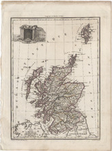
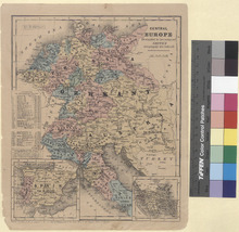
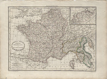
Detailed single page historical copper engraved map of the French Empire. This map depicts France, North and Central Italy, Northern Spain, Belgium, Luxembourg, Germany, Switzerland, Monaco, Andorra, San Marino, and parts of Austria, Croatia, Slovenia, England, and Wales. The map shows several geographic details on cities, towns, rivers, mountains, and islands. The map includes an inset map int the top right quadrant showing the Netherlands. The map features a vignette incorporating the title. Cities appearing on this map include: Italy: Domodossola, Sondrio, Bormio, Udine, Spilemberg (Spilimbergo), Tolmezzo, Piave di Cadore (Pieve di Cadore), Bellune (Belluno), Felire (Feltre), Brixen, Pruneken (Bruneck), Sterzing, Bolzano, Meran (Merano), Glurens (Glurns), Cles, Neumarkt, Trente (Trento), Preor (Preore), Brio (?), Cividale, Varallo (Varallo Pombia), Ivree (Ivrea), Santia (Santhià), Chivasso, Turin, Aoste (Aosta), Suze (Susa), Riva (Riva del Garda), Salo (Salò), Schio, Verone, (Verona) Castiglione (Castiglione delle Stiviere), Mantoue (Mantua), Clusone, Lecco, Bergame (Bergamo), Brescia, Chiari, Crema, Verolanova (Verloanuova), Lodi, Cremone (Cremona), Plaisance (Piacenza), Como, Arona, Gallarate, Monza, Milan, Novare (Novara), Vigevano, Pavie (Pavia), Verceil (Vercelli), Casal (Casale Monferrato), Voghera, Ceneda (Vittorio Veneto), Asiago, Bassano (Bassano del Grappa), Trevise (Treviso), Franco (Castelfranco Veneto), Vicenze (Vicenza), Padoue (Padua), Venise (Venice), Este, Adria, Rovigo, Pordenone, Conegliano, Trieste, Gorice (Gorizia), Gradisca (Gradisca d'Isonzo), Aquilija (Aquileia), Valence (Valenza), Marengo (Spinetta Marengo), Alexandrie (Alessandria), Novi (Novi Ligure), Aqui (Acqui Terme), Chiavari, Gene (Genoa), Montenotte (Cairo Montenotte), Savone (Savona), Asti, Alba, Ceva, Coni (Cuneo), Saluces (?), Savigliano, Pignerole (Pinerolo), Ferrare (Ferrara), Cento, Imola, Ravenne (Ravenna), Faenza, Forli (Forlì), Bologne (Bologna), Modene (Modena), Mirandolle (Mirandola), Guastalla, Casalmaggiore, Reggio (Reggio Emilia), Vergato, Fiorenzuola (Fiorenzuola d'Arda), Bobbio, Bardi, Parme (Parma), Fornovo (Fornovo di Taro), Villafranca, Brugnato, Sarzana, Rimini, Cervia, Fermo, Tolentino, Macerata, Ancone (Ancona), Sinigaglia (Senigallia), Fano, Pesaro, Urbino, Jesi, Cagli, Fabriano, Camerino, Assisi, Perugia, Fratta, Arezzo, Mt. Alcino (Montalcino), Massa (Massa Marittima), Sienne (Siena), Volterra, Livourne (Livorno), Pisa, Empoli, Florentis (Florence), Pistoia, Lacques (Lucca), Massa, Port Maurice (Imperia or Porto Maurizio), S. Remo (Sanremo), Mt. Rotonda (Monti Sibillini), Popolo (Popoli), Aquila (L'Aquila), Chieti, Teramo, Ascoli (Ascoli Piceno), Mte. Ailo (Montalto delle Marche), Introdoca (Antrodoco), Rieti, Narni, Civita Castellana, Viterbe (Viterbo), Spoleto, Norcia, Foligno, Todi, Orvieto, Civita Vecchia (Civitavecchia), Toscanella (Tuscania), Acquapendente, Grosseto, Piombino, Porto Ferrajo (Portoferraio), Palo (Ladispoli), Peschio Asseroto, Tivoli, Ostui (Ostia), Rome, Veiletri (Velletri), Frosinone, Astura (Torre Astura), Ponte Corvo (Pontecorve), Terracine (Terracina), and Gaete (Gaeta). San Marino: San Marin (San Marino Cittia). Monaco: Monaco France: Corte, Vico, Calvi, I. Rousse (L'Île-Rousse), S. Florent (Saint-Florent), Bastia, Pto. Vecchio (Porto-Vecchio), Sartene (Sartène), Valinco, Ajaccio, Zicavo, Collioure, Perpignan, Salces (Salses-le-Château), Prades, Ax (Ax-les-Thermes), Foix, and S. Girons (Saint-Girons), Puget-Theniers (Puget Thèniers), Nice, Castellane, Grasse, Frejus (Frèjus), Draguignan, St. Tropez (Saint-Tropez), Toulon, La Ciotat, Marseille, Brignolles (Brignoles), Riez, Aix (Aix-en-Provence), Apt, Forcalquier, Arles, Tarascon, Avignon, Aiguesmortes (Aigues-Mortes), Montpellier, Cette (Sète), Nismes (Nîmes), Sijean (Sigean), Narbonne, Bèziers (Beziers), Lodeve (Lodève), St. Afrique (Saint-Affrique), La Canne (Lacaune), St. Pons (Saint-Pons-de-Thomières), Carcassonne, Limoux, Pamiers, Castelnaudary, Villefranche (Villefranche-de-Lauragais), Toulouse, Lavaur, Castres, Gaillac, Alby (Albi), Condom, Lectoure, Auch, Muret (?), Mirande (?), Lombes (Lombez), St. Gaudens (Saint-Gaudens), Mt. de Mansan (Mont-de-Marsan), St. Sever (Saint-Sever), Pau, Tarbes, Oliron (Oloron-Sainte-Marie), Bagneres (Bagnères-de-Bigorre), Argeles (Argelès-Gazost), Dax, Orthes (Orthez), Bayonne, Mauleon (Mauléon-Licharre), St. Jean de Lux (Saint-Jean-de-Luz), Briancon (Briançon), Embrna (Embrun), Barcelonnette, Digne (Digne-les-Bains), Sisteron, Gap, Corps, Die, Carpentras, Orange, Uzes (Uzès), Viviers, Nyons, Montelimart (Montélimar), Privas, Valence, Vernoux (Vernoux-en-Vivarais), Mende, L'Argentiere (Largentière), Florac, Alais (Alès), Le Vigan, Aurillac, S. Chely (Saint-Chély-d'Apcher), Espalion, Marvejols, Rhodez (Rodez), Milhau (Millau), Gourdon, Figeac, Cahors, Villefranche (Villefranche-de-Rouergue), Montauban, Bergerac, Sarlat (Sarlat-la-Canéda), Villereal (Villeréal), Velleneuve (Villeneuve-sur-Lot), Agen, Castel Sarasin (Castelsarrasin), Nerac (Nérac), Libourne, Bordeaux, La Reolle (La Réole), Langon, Garonne (Meilhan-sur-Garonne), Marmande, Bazas, Roquefort, Lipostey (Liposthey), S. Maurice (Bourg-Saint-Maurice), Moutiers (Moûtiers), Conflans (Albertville), S. Jean de Maurienne (Saint-Jean-de-Maurienne), Grenoble, S. Marcellin (Saint-Marcellin), la Tour du Pin (La Tour-du-Pin), Chambery (Chambéry), Quirieu (Bouvesse-Quirieu), Belley, Annecy, Trevoux (Trévoux), Villefranche (Villefranche-sur-Saône), Lyon, Vienne, St. Etienne (Saint-Étienne), Roussillon (Le Péage-de-Roussillon), Tournon (Tournon-sur-Rhône), Thiers, Montbrison, Ambert, Brioude, Issengeaux (Yssingeaux), le Puy (Le Puy-en-Velay), Riom, Clermont (Clermont-Ferrand), Issoire, Murat, St. Flour (Saint-Flour), Mauriac, Argentat, Brives (Brive-la-Gaillarde), Tulle, Ussel, Aubusson, Bourganeuf, St. Yrieix (Saint-Yrieix-la-Perche), Periqueux (Périgueux), Nontron, Rochechouart, Limoges, Riberac (Ribérac), Barbezieux (Barbezieux-Saint-Hilaire), Blaye, Jonzac, Angouleme (Angoulême), Cognac, St. Jean d'Angely (Saint-Jean-d'Angély), Medoc (Médoc), Lesparre (Lesparre-Médoc), Saintes, Marennes, Rochefort, Pontarlier, Thonon (Thonon-les-Bains), Bonneville, Poligny, Lons le Saunier (Lons-le-Saunier), St. Claude (Saint-Claude), Nantua, Verdun (Verdun-sur-le-Doubs), Chalons (Chalon-sur-Saône), Louhans (Louhans-Châteaurenaud), Macon (Mâcon), Bourg (Bourg-en-Bresse), Autun, Bourbonlancy (Bourbon-Lancy), Charolles, la Palisse (Lapalisse), Roanne, S. Amand (Saint-Amand-Montrond), Moulins, Montlucon (Montluçon), Gannat, Issoudun, Chateauroux (Châteauroux), la Chatre (La Châtre), Boussac, Gueret (Guéret), le Blanc (Le Blanc), Bellac, Chatellerault (Châtellerault), Poitiers, Confolens, Civray, Ruffec, Melle, Niort, Partenay (Parthenay), Bressuire, la Rochelle (La Rochelle), Fontenay (Fontenay-le-Comte), Mareuil (Mareuil-sur-Lay-Dissais), Napoleon (La Roche-sur-Yon), Montaigu, les Sables d'Olonne (Les Sables-d'Olonne), Ensisheim, Belfort, Altkirch, Lure, Baume (Baume-les-Dames), S. Hypolite (Saint-Hippolyte), Jussey, Langres, Champlitte, Vesoul, Gray, Besancon (Besançon), Dole, Beaune, Dijon, Semur (Semur-en-Auxois), Montbard, Chatillon (Châtillon-sur-Seine), Tonnerre, Avallon, Chat Chinon (Château-Chinon), Joigny, Auxerre, Clamecy, Nevers, la Charite (La Charité-sur-Loire), Sancerre, Cosne (Cosne-Cours-sur-Loire), Briare, Gien, Bourges, Romorantin (Romorantin-Lanthenay), Blois, Beaugency, Orleans (Orléans), Loches, Tours, Amboise, Vendome (Vendôme), S. Calais (Saint-Calais), Loudun, Chinon, Saumur, Angers, la Fleche (La Flèche), Tiffauges, Nantes, Beaupreau (Beaupréau), Ancenis, Segre (Segré), Chateaubriand (Châteaubriant), Chat. Gontier (Château-Gontier), Paimbaeuf (Paimbœuf), Savenay, Redon, Ploermel (Ploërmel), Vannes, l'Orient (Lorient), Lauterbourg, Haguenau, Saverne, Strasbourg, Sehlestadt (Sélestat), Colmar, Chat. Salins (Château-Salins), Sarrebourg, Luneville (Lunéville), St. Die (Saint-Dié-des-Vosges), Epinal (Épinal), Commercy, Nancy, Toul, Neufchateau (Neufchâteau), Mirecour, Chaalons (Châlons-en-Champagne), Vitry (Vitry-le-François), Bar (Bar-le-Duc), Vassy (Wassy), Chaumont, Bar sur Seine (Bar-sur-Seine), Arcis (Arcis-sur-Aube), Nogent (Nogent-sur-Seine), Troyes, St. Denis (Saint-Denis), Paris, Coulommiers, Meaux, Corbeil (Corbeil-Essonnes), Melun, Provins, Fontainebleau, Sens, Montargis, Mantes (Mantes-la-Jolie), Versailles, Dreux, Chartres, Etampes (Étampes), Verneuil (Verneuil-sur-Avre), Mortagne (Mortagne-au-Perche), Nogent le Rotrou (Nogent-le-Rotrou), Mamers, Chateaudun (Châteaudun), Falaise, Argentan, Domfront, Alencon (Alençon), Mayenne, le Mans (Le Mans), Vire, Mortain, Granville, Avranches, Fougeres (Fougères), Vitre (Vitré), Laval, Rennes, S. Malo (Saint-Malo), Dinan, Monfort (Montfort-sur-Meu), Napoleonville (Pontivy), Loudeac (Loudéac), Lannion, Guingamp, St. Brieux (Saint-Brieuc), Morlaix, Brest, Chateaulin (Châteaulin), Quimper, Audierne, Wissenburg (Wissembourg), Sarreguemines, Metz, Briey, Thionville, Verdun, Ste. Menehould (Sainte-Menehould), Vouziers, Montmedy (Montmédy), Rethel, Sedan, Mezieres (Charleville-Mézières), Rocroy (Rocroi), Epernay (Épernay), Chat. Thierry (Château-Thierry), Rheims (Reims), Soissons, Laon, la Fere (La Fère), and Vervins, Senlis, Clermont, Compiegne (Compiègne), Montdidier, St. Quentin (Saint-Quentin), Peronne (Péronne), Pontoise, Vernon, Gd. Andelys (Les Andelys), Beauvais, Breteuil (Breteuil-sur-Noye), Amiens, Neufchatel (Neufchâtel-en-Bray), Evreux (Évreux), Bernay, Pt. Audemer (Pont-Audemer), Louviers, Rouen, Yvetot, Fecamp (Fécamp), S. Vallery (Saint-Valery-en-Caux), Dieppe, Lizieux (Lisieux), P. leveque (Pont-l'Évêque), Caen, le Havre (Le Havre), Bayeux, S. Lo (Saint-Lô), Valognes, Coutances, Cherbourg (Cherbourg-Octeville) Givet, Conde (Vieux-Condé), Maubeuge, Avesnes (Avesnes-sur-Helpe), Lille, Hazebrouck, Bethune (Béthune), Douay (Douai), Arras, Cambray (Cambrai), Doulens (Doullens), Treport (Le Tréport), Abbeville, Montreuil, S. Pol (Saint-Pol-sur-Ternoise), Boulogne (Boulogne-sur-Mer), St. Omer (Saint-Omer), Calais and Dunkerque (Dunkirk). Spain: Palamos (Palamós), Alataro, Barcelone (Barcelona), Manresa, Cervera, San Sadurme, Pons (Ponts), Balaguer, Lerida (Lleida), Barbastro, Sarinena (Sariñena), Zuerca (Zuera), Saragosse (Zaragoza), Calatayud, Girone (Girona), Ripoll, Roses, Peralada, Puigcerda (Puigcerdà), Solsona, Uirgel (La Seu d'Urgell), Povla (La Pobla de Segur), Ainsa (Aínsa), Benavarre (Benabarre), Huesca, Jaca, Sanguessa (Sangüesa), Roncevalles (Roncesvalles), Pampelune (Pamplona), Estella (Estella-Lizarra), Malagro (Milagro), Tudela, Vittoria (Vitoria-Gasteiz), Miranda de Ebro, Frias (Frías), Saldana (Saldaña), Savero (Sabero), Leon (León), Fontarabie (Hondarribia), Santestevan (?), S. Sebastien (San Sebastián), Deba, Laredo, Valmaseda (Balmaseda), Santander, S. Pedro (?), Vasieda (?), Llanes, Infiesto, el Campo (Campo de Caso), Riba de Sella (Ribadesella), Willaviciosa (Villaviciosa), and Gixcon (Gijón). Croatia: Fiume (Rijeka), Rovigno (Rovinj), and Omago (Umag). Slovenia: Capo d'Istria (Koper), Stein (Kamnik), and Ratmansdorf (Radovljica). Austria: Ferlach, Volkelmarkt (Völkermarkt), Strasbourg (Straßburg), Clagenfurt (Klagenfurt), Gmund (Gmünd), Villach, Lienz, Altenmarkt (Altenmarkt bei Sankt Gallen), Judenbourg (Judenburg), Unt Haus (?), Rottemann (Rottenmann), Murau, Salzbourg (Salzburg), Radstadt, Damsweg (Tamsweg) Kufstein, Schwaz, Innspruck (Innsbruck), Landek (Landeck), Imst, Bregentz (Bregenz), Feldkirch, Steyr, Linz, Wels, Scharding (Schärding), Ried (Ried im Innkreis), and Braun (Braunau am Inn). Germany: Bergtesgaden (Berchtesgaden), Mittenwald, Schong (Schongau), Kaufbeuren, Memmingen, Moesckirch (Messkirch), Geislingen (Geisingen), Constance (Konstanz), Freybourg (Freiburg im Breisgau), Passau, Wasserbourg (Wasserburg am Inn), Haag (Haag in Oberbayern), Munich, Dingelfing (Dingolfing), Neustadt (Neustadt an der Donau), Ingolstadt, Rain, Augsbourg (Augsburg), Nordlingen (Nördlingen), Ulm, Biberach (Biberach an der Riss), Canstadt (Bad Cannstatt), Carlsruhe (Karlsruhe), Stuttgard (Stuttgart), Tubingen (Tübingen), Gamerdingen (Gammertingen), Ettenheim, Offenbourg (Offenburg), Kehl, Darmstadt, Manheim (Mannheim), Spire (Speyer), Bingen (Bingen am Rhein), Simmern, Kirn, Worms, Kaiserslautern, 2 Ponts (Zweibrücken), Landau, Sarrebruck (Saarbrücken), Birkenfeld, Treves (Trier), Giessen, Weilbourg (Weilburg), Francfort (Frankfurt), Neustadt (?), Siegen, Neu Wied (Neuwied), Coblentz (Koblenz), Mayence (Mainz), Cologne, Siegberg (Siegburg), Juliers (Jülich), Bonn, Blankenheim, Pruym (Prüm), Sinsig (Sinzig), Bitbourg (Bitburg), Dasbourg (Dasburg), Aix la Chapelle (Aachen), Lipstadt (Lippstadt), Arensberg (Arnsberg), Lunen (Lünen), Wesel, Duisbourg (Duisburg), Dusseldorf (Düsseldorf), Creveld (Krefeld), Cleves (Kleve), Munster (Münster), Rees, Borken, Verden, Hoya, Nienburg, Minden, Detlingen (Dötlingen), Cloppenbourg (Cloppenburg), Quakenbruck (Quakenbrück), Osnabruck (Osnabrück), Meppen, Lengen (Lingen), Northorn (Nordhorn), Steinfurt, Travemunde (Travemünde), Lubeck (Lübeck), Lauenbourg (Lauenburg), Lunebourg (Lüneburg), Hambourg (Hamburg), Harbourg (Harburg), Rotenbourg (Rotenburg an der Wümme), Stade, Gluckstadt (Glückstadt), Cuxhaven, Bremerlehe (Bremerhaven), Gestendorf (Geestendorf), Osterholz, Bremen, Oldenbourg (Oldenburg), Jever, Aurich, and Emden. Switzerland: Salz (?), Meyenfeld (Maienfeld), Coire (Chur), Tusis (Thusis), Stans, Dissentis (Disentis), Bellinzone (Bellinzona), Locarno, Ingano (Lugano), Brigg (Brig-Glis), Brienz, Thun, Berne (Bern), Sion, Yverdun (Yverdon-les-Bains), Fribourg, Lausanne, Aubonne, S. Maurice (Saint-Maurice), Nyon, Geneve (Geneva), St. Gall (Sankt Gallen), Appenzell, Frauenfeld, Zurich (Zürich), Glaris (Glarus), Schweitz (Schwyz), Schafhausen (Schaffhausen), Lucerne, Soloure (?), Arau (Aarau), Delemont (Delémont), Bale (Basel), Bienne (Biel/Bienne, Poratrui (Porrentruy), and Neufchatel (Neuchâtel). Czech Republic: Rosenberg (Rožmberk nad Vltavou) Luxembourg: Luxembourg and Diekirck (Diekirch) Belgium: Neufchateau (Neufchâteau), Bouillon, Hasselt, Liege (Liège), Verviers, Malmedy S. Hubert (Saint-Hubert), Huy, Marche (Marche-en-Famenne), Dinant, Namur, Louvain (Leuven), Nivelles, Bruxelles (Brussels), Tournay (Tournai), Mons, Courtray (Kortrijk), Ypres, Peer, Turnhout, Anvers (Antwerp), Malines (Mechelen), Dendermonde, Ecloo (Eeklo), Gand (Ghent), Bruges, Ostende (Ostend), Nieuport (Nieuwpoort), and Furnes (Veurne). Netherlands: Maestricht (Maastricht), Nimegue (Nijmegen), Grave, Bois le Duc ('s-Hertogenbosch), Venlo, Ruremonde (Roermond), Breda, Berg op Zoom (Bergen op Zoom), Middelbourg (Middelburg), Axel, Arnheim (Arnhem), Thiel (Tioel), Dordrecht, Assen, Almeloo (Almelo), Amersfort (Amersfoort), Zutphen, Deventer, Zwol (Zwolle), Kainder (?), Heerenveen, Utrecht, la Have (The Hague), Leyde (Leiden), Amsterdam, Alkmaar, Hoorn, Vlinschoten (Winschoten), Groningue (Groningen), Leeuvarden (Leeuwarden), and Sneek. England: Hastings, New-Shoreham (Shoreham-by-Sea), Chichester, Dorchester, Bridport, Exeter, Plymouth, Launsceston (Launceston), Eddistone (?), Padstow, Penzanes (Penzance), Douvres (Dover), Margate, Canterbury, Colchester, Horsham, Tunbridge (Tonbridge), Windsor, Londres (London), Hertford, Oxford, Reading, Wincester (Winchester), Salisbury, Wells, Bath, Bristol, Glocester (Gloucester), and Bridgewater (Bridgwater). Wales: Caermarthen (Carmarthen). Source publication: Atlas Complet Du Precis De la Geographie Universelle De M. Malte Brun dressee par M. Lapie Capitaine Ingenieur Geographie Pierre M. Lapie (1779-1850) and his son Alexandre Emile Lapie (1809-1850) were French cartographers and engravers active in the early part of the 19th Century. The Lapies were commissioned officers in the French army holding the ranks of Colonel and Caipitan, respectively. Alexander enjoyed the title of "First Geographer to the King", and this title appears on several of his atlases. Both father and son were exceptional engraversand fastidious cartographers. Working separately and jointly they published four important atlases, an 1811 Atlas of the French Empire (Alexander), the 1812 Atlas Classique et Universel (Pierre), the Atlas Universel de Geographie Ancienne et Modern (joint issue), and the 1848 Atlas Militaire (Alexander). They also issued many smaller maps and independent issues. All of these are products of exceptional beauty and detail. Conrad Malte-Brun (1755-1826) was an important late 18th and early 19th Century Danish/French cartographer and revolutionary. Conrad was born in Thisted, Denmark. His parents encouraged him to a career in the Church, but he instead enrolled in the University of Copenhagen. In the liberal hall of academia Conrad became an ardent supporter of the French Revolution and the ideals of a free press. Despite the harsh censorship laws of crown prince Frederick VI, Malte-Brun published numerous pamphlets criticizing the Danish government. He was finally charged with defying censorship laws in 1799 and forced to flee to Sweden and ultimately France. Along with colleague Edme Mentelle, Malte-Brun published his first cartographic work, the Geographie mathematique, physique et politique de toutes les parties du monde (6 volumes published between 1803 and 1807). Conrad went on to found Les Annales des Voyages (in 1807) and Les Annales des Voyages, de la Geographie et de l'Histoire (in 1819). He also founded the Paris Societe de Geographie. In time, Conrad became known as one of the finest French cartographers of his time.

Carte De Brie (1648)

Image
Copper engraved map of the Brie, France. The map is adorned with a decorative cartouche. The map is from the publication: Cartes generales de toutes les Provinces de France et d'Espaigne, which translates to: General maps of all of the Provinces of France and Spain. The Cartographer, Nicolas Tassin, was active from 1633 until 1655 and was appointed "Royal Cartographer" at Dijon before setting up as an engraver in Paris where he issued various collections of small maps and plans. Cities appearing on this map include: Île-de-France: Hauts-de-Seine: Coulombe (Colombes), Nanterre, Bourla Reine (Bourg-la-Reine), and Anthony (Antony). Seine-Saint-Denis: Le Bourget, S. Denis (Saint-Denis), Villemonde (Villemomble), and Neuilly (Neuilly-sur-Marne/Neuilly-Plaisance). Paris: Montmartre (Now part of the 18th arrondissement of Paris since January 1, 1860), Charone (Now the Charonne quarter in the 20th arrondissement of Paris since 1860), Paris, and Auteuil (Now Neuilly-Auteuil-Passy in the 16th arrondissement of Paris since 1859/1860). Val-de-Marne: Vincene (Vincennes), Chareton (Charenton-le-Pont/Saint-Maurice), Iantilly (Gentilly), Villeneufue (Villeneuve-le-Roi), S. Maur (Saint-Maur-des-Fossés), Boissy (Boissy-Saint-Léger), Villeneuue S. George (Villeneuve-Saint-Georges), Villemont (Villecresnes?), Laqueue (La Queue-en-Brie), and Gournay (Gournay-sur-Marne). Essonne: Bieure (Bièvres), Pallezeau (Palaiseau), Lonjumeau (Longjumeau), Montlhery (Montlhéry), Bandou (Bondoufle), Valpetit (Vert-le-Petit), Valgrand (Vert-le-Grand), Chastre (Arpajon), Climuille (?), Etrechy (Étréchy), Corbeil (Combined with Essonnes in 1951 to form Corbeil-Essonnes), Esone (Combined with Essonnes in 1951 to form Corbeil-Essonnes), Coudray (Le Coudray-Montceaux), Leplessy (?), Villeroy (Parc de Villeroy), Lafertealais (La Ferté-Alais), Bunent (?), Milly (Milly-la-Forêt), Mouuielle (?), and Choisy (Soisy-sur-Seine). Seine-et-Marne: S. Sauueu (Saint-Sauveur-sur-École), Arbonne (Arbonne-la-Forêt), Fontaine-belieau (Fontainebleau), Barbusson (Barbizon), Orgenois (Orgenoy), Samois (Samois-sur-Seine), Brosle (Brolles?), Melug (Melun), Moret (Moret-sur-Loing), Chelle (Chelles), Mougny (?), Annet (Annet-sur-Marne), Meaux, Greiz (Gretz-Armainvilliers), Bry C. Robert (Brie-Comte-Robert), Beuerme (?), Armoiuilliers (Gretz-Armainvilliers), Pont Carre (Pontcarré), Lagny (Lagny-sur-Marne), Hermiere (Hermiéres), Estropelef (?), Fontenay (Fontenay-Trésigny), Croquetin (Courquetaine), Tournan (Tournan-en-Brie), Iamagne (?), Mostir (?), Lehausois (La Houssaye-en-Brie?), Lumigne (Now Lumigny-Nesles-Ormeaux after the 1973 fusion of Lunigny, Nesles, and Ormeaux), Pamerse (Pommeuse), Totquin (Touquin), Rozoy (Rozay-en-Brie), Pessy (Pécy), La Chapelle (La Chapelle-Iger), Verdoye (Vaudoy-en-Brie), Beaulieu (?), Setraid (?), La Ferte Sous Jouerre (La Ferté-sous-Jouarre), Coully (Couilly-Pont-aux-Dames), Mouceaux (Montceaux-lès-Meaux), Crecy (Crécy-la-Chapelle), Faux (?), Foussy (?), Guerard (Guérard), Rucle Velours (?), Colommiers (Coulommiers), Rebes (Rebais), La Ferte gaucher (La Ferté-Gaucher), Marche (Marchais-en-Brie?), Chaliden(?), Lasmeullieres (?), Sabloniere (Sablonnières), Lespine (?), Gregy (Now Évry-Grégy-sur-Yerre after the fusion of Évry-les-Châteaux and Grégy-sur-Yerre on January 1, 1973), Sipelle (?), Cramaiaux (Moissy-Cramayel), Aupierre (Aubepierre-Ozouer-le-Repos), Ieble (Yèbles), Monsenay (Moisenay), Simery (?), La Chapelle (La Chapelle-Gauthier), Nangis, Courlen (?), Chastillon (Châtillon-la-Borde), Barbeau (Barbeau Abbey in Fontaine-le-Port), Herissee (Héricy), Vinpele (Vimpelles), Montereau (Montereau-Fault-Yonne), Montigny (Montigny-Lencoup), Damemarie (Donnemarie-Dontilly), Quercy (?), Songnol (Sognolles-en-Montois), Vieux Champne (Vieux-Champagne), Chenoise, Pampillon (?), Villegagno (Bannost-Villegagnon), S. Loup (Saint-Loup-de-Naud), Chancoile (?), Prouins (Provins), S. Sauueur (Saint-Sauveur-lès-Bray), Grauon (Gravon), Bray (Bray-sur-Seine), Noiens (Noyen-sur-Seine), Euerlis (Everly), Flouy (?), Fouchier (Fouchères), Pigreux (?), Charlemaiso (Chalmaison), Villegray (Louan-Villegruis-Fontaine), S. Simon (Saint-Siméon), Maleuaue (?), Peuillon (?), Ludon (Leudon-en-Brie), and Borsroy (?). Nord-Pas-de-Calais-Picardie: Aisne: Chau. Thierry (Château-Thierry), Nogentel, Parois (Paroy), Conde (Condé-en-Brie/Celles-lès-Condé), Montigny (Montigny-lès-Condé), Nogent Lartaut (Nogent-l'Artaud), Verdou (?), and Mallemaison (?). Alsace-Champagne-Ardenne-Lorraine: Marne: Rieux, Neusuy (Neuvy), Sedane, Montmirel (Montmirail), Bouchy (Bouchy-Saint-Genest), S. Bon (Saint-Bon), Chartemarie, and Montgenou (Montgenost). Aube: Corseroy (Courceroy), Nogent (Nogent-sur-Seine), Pont (Pont-sur-Seine), Villenosce (Villenauxe-la-Grande), and Courtinan (Courtavant?).

Carte du Chemin de Ust-Kameno-Gorsk jusque' aux Ruines d' Ablaikit (1779)

Image
This is an engraving of the Buddhist Monastery of Ablaikit and a map of the location of the ruins published in 1779. The map shows the city of Ust-Kameno-Gorsk (Oskemen) in Kazakstan as are the Monastery ruins. In the upper left is a map of the area of Kazakstan containing the ruins with the French title: Carte du Chemin de Ust-Kameno-Gorsk jusqu' aux Tuines d' Ablaikit which translates to Map of Ust-Kameno-Gorsk and Path to the Ruins of Ablaikit. In the upper right is a map of the Monastery grounds with a title in French: Plan de l'Enceinte des Murs du Temple d'Ablaikit which translates to Map of the Temple Walls of Ablaikit. In the bottom section is an image of the Monastery and Temple itself. In French is Plan du Temple which translates to Temple Map showing a plan of the inner temple. There is also a detailed image of the Monastery and Temple with the French title Elevation du Temple d'Ablaikit which translated to Elevation of the Temple of Ablaikit. Below the map is the French title Plan des Environs et de L'Enceinte du Temple D'Ablaikit which translated to plan of the Temple and Surroundings of Ablaikit. Jacques-Nicolas Bellin who lived from 1703 to 1772 was an important cartographer of the 18th century. He is understood as geographe de cabinet and a transitional mapmaker spanning the gap between 18th and early 19th century cartographic styles. His long career as Hydrographer and Ingénieur Hydrographe at the French Dépôt des cartes et plans de la Marine resulted in hundreds of high quality nautical charts of practically everywhere in the world. His work focuses on function and accuracy tending in the process to be less decorative than the earlier 17th and 18th century cartographic work. Unlike many of his contemporaries, Bellin was always careful to cite his references and his scholarly corpus consists of over 1400 articles on geography prepared for Diderot's Encyclopedie. In addition to numerous maps and charts published during his lifetime, many of Bellin's maps were updated (or not) and published posthumously. He was succeeded as Ingénieur Hydrographe by his student, also a prolific and influential cartographer, Rigobert Bonne. Jakob van der Schley who lived from 1715 to 1779 was a Dutch engraver and painter. He has engraved the maps and views of the maps of the Dutch edition of Prevost's Histoire General des Voyage.

Map No. 4. United States (1853)

Image
Detailed single page historical steel engraved map of the Southern Mid Atlantic States published in 1853. This map depicts North Carolina, Virginia (Virginia and West Virginia), Maryland as well as the District of Columbia, and Delaware, and parts of South Carolina, Georgia, Tennessee, Kentucky, Ohio, and Pennsylvania. The map shows several geographic details on cities, towns, rivers, mountains, and islands. Along the bottom edge is written: Entered according to Act of Congress in the year 1853 by Daniel Burgess & Co in the Clerks office of the Southern District of New York. States appearing on the Map: North Carolina, Virginia (Virginia and West Virginia), Maryland, Delaware, South Carolina, Georgia, Tennessee, Kentucky, Ohio, and Pennsylvania as well as the District of Columbia. Cities appearing on the Map: North Carolina: Smithville (Name changed to Southport in 1887), Beaufort, Kenansville, Onslow C. H. (?), S. Washington (Ghost Town), Wilmington, Whitesville (Whiteville), Elizabeth (Elizabethtown), Lumberton, Rockingham, Wadesboro, Columbia, Plymouth, Williamston, Washington, Newbern (New Bern), Trenton, Kingston (Kinston), Goldsboro, Snow Hill, Greenville, Tarboro, Nashville, Windsor, Clinton, Fayetteville, Smithfield, Raleigh, Chapel Hill, Carthage, Lawrenceville (Ghost Town soon after 1842), Pittsboro, Ashboro, Monroe, Albemarle, Concord, Charlotte, Dallas, Lincolnton, Salisbury, Statesville, Lexington, Mocksville, Lenoir, Morgantown (Morganton), Shelby, Rutherfordton, Burnsville, Hendersonville, Ashville (Asheville), Waynesville, Franklin, Murphy, Eliz. City (Elizabeth City), Hertford, Gatesville, Edenton, Winton, Jackson, Halifax, Gaston, Louisburg, Oxford, Warrentown (Warrenton), Roxboro, Hillsboro (Hillsborough), Greensboro, Yanceyville, Wentworth, Salem, Wilkesboro, Germanton, Rockford, and Jefferson. South Carolina: Marion, Cheraw, Camden, Columbia, Yorkville (Name changed to York in 1915), Laurensville (Name changed to Laurens in 1873), Greenville, Abbeville, and Anderson. Tennessee: Knoxville. Virginia (Virginia and West Virginia): Virginia: Norfolk, Suffolk, Portsmouth, Jerusalem (Name changed to Courtland in 1888), Hicksford (Merged in 1887 with Belfield and the name was changed to Emporia), Lawrenceville, Boydton Banister, Lewiston (Name changed to Lunenburg), Matinsville, Chatham, Rocky Mount, Taylorsville (Name changed to Stuart in 1884), Greenville (?), Hillsville, Jacksonville (Name was changed to Floyd in 1896), Wytheville, Marion, Abingdon, Lebanon, Estillville (Name changed to Gate City in 1890), Jonesville, Eastville, Drummond (Name changed to Accomac in 1893), Hampton, Williamsburg, York T. (Yorktown), Rappahannock (Tappahannock?), Heathsville, Petersburg, Richmond, Scotts V. (Name changed to Powhatan), Henderson V. (Hendersonville), Marys V. (Name changed to Charlotte Court House), Maysville (Name changed to Buckingham), Palmyra, Monticello, Lovington (Lovingston), Lynchburg, Liberty (Name changed to Bedford in 1890), Fincastle, Lexington, Covington, Christiansburg, Salem, Newbern, Parisburg (Pearisburg), Jeffersonville (Name changed to Tazewell), Bowling Green, Fredericksburg, Brentsville, Warrenton, Charlottesville, Faifax (Name changed to Culpeper in 1869), Harrisonburg, Luray, Woodstock, Front Royal, Staunton, Warm Springs, Leesburg, Berryville, and Winchester. West Virginia: Union, White Sulphur Spr. (White Sulphur Springs), Lewisburg, Princeton, Franklin, Beverly, Huntersville, Summerville (Summersville), Sutton, Glenville, Fayetteville, Charleston, Ripley, Trouts Hill (Name changed to Wayne in 1911), Barboursville, Guyandott (Now a neighborhood in Huntington), Point Pleasant, Charleston (Charles Town), Martinsburg, Harpers Ferry, Romney, Bath (Name changed to Berkeley Springs in 1861), Phillipi (Philippi), Pruntytown, Kingwood, Morgantown, Weston, Clarksburg, Fairmount (Fairmont), Middletown (Middlebourne), N. Martinsville (New Martinsville), Moundville (Moundsville), Harrisville, Parkersburg, Wellsburg, and Wheeling. Kentucky: Piketon (Name changed to Pikeville in 1850), Louisa, and Greenupsburg (Name changed to Greenup in 1872). Maryland: Snow Hill, Princess Ann (Princess Anne), Cambridge, Easton, Annapolis, Leonard (Leonardtown), Pr. Frederick (Prince Frederick), Up Marlboro (Upper Marlboro), Pt. Tobacco (Port Tobacco), Centre V. (Centreville), Chester T. (Chestertown), Havre de Grace, Belair (Bel Air), Baltimore, Westminster, Rockville, Frederick, Emmetsburg (Emmitsburg), Hagerstown, Hancock, and Cumberland. Delaware: George T. (Georgetown), Milford, Dover, Delaware City, New Castle, Newark, and Wilmington. District of Columbia (District of Columbia and Virginia): District of Columbia: Washington and Georgetown (Now a neighborhood in Washington since 1871). Virginia: Alexandria. Ohio: Portsmouth, Marietta, Zanesville, Chillicothe, Columbus, and Steubenville. Pennsylvania: Philadelphia, Columbia, York, Chambersburg, Harrisburg, Huntingdon, Hollidaysburg, Bedford, Pittsburg (Pittsburgh), and Beaver. Populations appearing on the Map: Smithville (Name changed to Southport in 1887): 1,500 Wilmington: 7,500 Plymouth: 1,000 Washington: 2,000 Newbern: 3,750 Kingston (Kinston): 250 Greenville: 2,000 Fayetteville: 1,500 Smithfield: 500 Raleigh: 4,000 Ashboro: 7,500 North Carolina: 869,000 Monroe: 250 Morgantown (Morganton): 250 Murphy: 250 Norfolk: 14,250 Portsmouth: 3,000 Edenton: 1,500 Oxford: 2,000 Petersburg: 14,000 Richmond: 27,500 Lynchburg: 8,000 Lexington: 1,750 George T. (Georgetown): 500 Milford: 2,250 Delaware: 92,000 Easton: 1,500 Annapolis: 3,000 Wasington: 40,000 Bowling Green: 500 Fredericksburg: 4,000 Alexandria: 8,750 Georgetown: 8,250 Front Royal: 500 Virginia (Virginia and West Virginia): 1,422,000 Charleston: 1,000 Dover: 4,500 Delaware City: 1,000 New Castle: 3,000 Wilmington: 14,000 Elkton: 1,250 Havre de Grace: 6,000 Baltimore: 169,000 Maryland: 583,000 Frederick: 6,000 Emmetsburg (Emmitsburg): 750 Hagerstown: 4,000 Leesburg: 1,500 Charleston (Charles Town): 1,500 Martinsburg: 2,250 Harpers Ferry: 1,750 Winchester: 3,500 N. Martinsville (New Martinsville): 250 Wheeling: 11,500