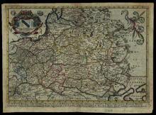
A mapp of the estates of the Great Duke of Russia Blanch, or Moscovia

Image
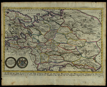
"To the Right Worshipfull, the Governer Consulls and Court of Assistance, of the Company of Moscovia Marchants This Map is humbly dedicated by Ric. Blome."nDecorative map with many towns, and with the mountains and forests of Russia shown. Two decorative wreaths in lower left corner, one displaying the dedication, the other displaying a shield with lion and boar on either side, with "God be our good guide" across banner underneath. Boundaries hand colored with different colors.nIn: Blome's A Geographical Description of the Four Parts of the World.

A mapp of the estates of the Crowne of Poland, where are the Kingdoms of of Poland with its Palatinates the Dutches of Russia : Noire Cujavia, Mozovia, Prussia, Lithuania, Volhynia, Podolia, etc.

Image
"To the Right Worshipfull Sr. Richard Otley of Pichford in Shropsheir Knight, this Mapp is humbly Dedicated by Ric: Blome."nDecorative map with many towns, and with the mountains and forests shown. Dedication in cartouche in upper left corner, with winds depicted above a lynx, a white shield with blue bar sinister and three sheaves of wheat; wings carrying quivers of arrows surround the figures. in the upper right corner is a fanciful white swan. Boundaries outlined with different colors. Hand colored cartouche.nRelief shown pictorially.

The whole Russian empire : The European Part of the Russian Empire With the Several Countries that are the Theatre of the Present War between the Turks and the Russians ; The Asiatic Part of The Russian Empire, with the adjacent Coast of North America

Image
"Published as the Act directs, 2 March 1772."nDecorative map depciting in detail towns, mountains and forests of Russia. Map shows Russia from the Black Sea in the west to the Bering Sea in the east. Includes Explanation of some Russian denominations and terms used in the confines of Tartary.

Taurica Chersonesus, hodie Przecopsca et Gazara dicitur

Image
Summary: Detailed map of the Ukraine and surrounding regions between the northern coast of the Black Sea and Moscow. Shows ports, fortified cities and the mouths of the Danube. Hand colored forests and boundaries. Two decorative cartouches. Cartouche in lower left is scale with angels. upper right is title with allegorical figures. Hand colored forests.

To His Most Serene and August Majesty Peter Alexovitz Absolute Lord of Russia &c. This map of Moscovy, Poland, Little Tartary, and ye Black Sea &c. is most humbly dedicated

Image
Appeared in a previous atlas, ca. 1714, with a variant imprint.nDecorative map with many towns, and with the mountains and forests and waterways depicted. Decorative allegorical cartouche with both secular and religious elements. Boundaries hand colored in different colors.nInsets: [Continuation], To avoid too great a contraction of the scale, the north part of Russia &c. is continued here -- The River Wolga from Peter Gorod to where it empties it self into the Caspian Sea -- Asoph or Asof and ye forts, and mouth of ye R. Don or Tanais &c.,Note: The greatest part of this map relating to Russia is done by the Czar's order, according to ye actual surveys of Cornelius Cruis His Czarrish Majesty's Vice Admiral, John Thesing, Captain Pamburg &c. whereby it appears that all other maps of this country yet extant are very erroneous and defective, and the Czar himself in this noble undertaking was present at ye soundings in in ye Palus Maeotis, and ye Straits of Kafa, which are set down in feet, and those in ye Black Sea in fathoms. NB. This map has all the improvements and corrections of Capt. Iohn Perry.,Prime meridians: London and Ferro Islands.nRelief shown pictorially and depths by sounds in feet and fathoms.nShirley, R. Maps in the atlases of the British Library, Vol. 1, T.Moll-4b, Map 13.

Taurica chersonesus nostra aetate Przecopsca et Gazara dicitur

Detailed map of the Crimea and surrounding regions between the northern coast of the Black Sea and Moscow. Shows ports, fortified cities and the mouths of the Danube. Decorative cartouche. An early state, with the original Mercator Cartouche. Borders, boundaries, forests and mountains hand colored.,Relief shown pictorially.nRemoved from Mercator's Atlas sive cosmographicae meditationes de fabrica mundi et fabricati figura. P. 105-106.nSignature on verso: Xx.nText on verso p.105-106 of Taurica chersonesus.nKoeman, C. Atlantes Neerlandici, v. 2, p. 340.