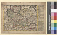
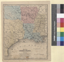
Partie Occidentale de l'Empire Francais (1812)

Image
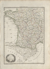
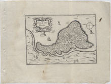
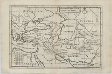
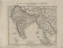
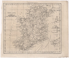
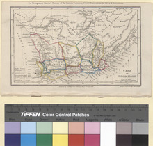
Highly detailed single page historical copper engraved map of the Western part of France and the Northern part of Spain. The map shows several geographic details on cities, towns, rivers, mountains, and islands. The map features a vignette incorporating the title. Regions shown: Pyrenees Orientales (Pyrénées-Orientales), Aude, Arriege (Ariège), Haute Garonne (Haute-Garonne), Hautes Pyrenees (Hautes-Pyrénées), Basses Pyrenees (Pyrénées-Atlantiques), Gard, Herault (Hérault), Aveiron (Aveyron), Tarn, Tarn et Garonne (Tarn-et-Garonne), and Gers. Cities shown: France: Languedoc-Roussillon-Midi-Pyrénées: Pyrenees Orientales (Pyrénées-Orientales): Elne, Pt. Vendre (Port-Vendres), Ceret (Céret), Prats de Mollo (Prats-de-Mollo-la-Preste), Perpignan, St. Paul (Saint-Paul-de-Fenouillet), and Prades. Aude: Leucate, Ouillan (Quillan), Sijean (Sigean), la Grasse (Lagrasse), Narbonne, Castelnaudary, Carcassonne, and Limoux. Arriege (Ariège): Foix, Belesta (Bélesta), Tarascon (Tarascon-sur-Ariège), Ax (Ax-les-Thermes), St. Girons (Saint-Girons), Seix, Pamiers, and Mirepoix. Haute Garonne (Haute-Garonne): S. Beat (Saint-Béat), Bagneres de Luchen (Bagnères-de-Luchon), St. Gaudens (Saint-Gaudens), St. Bertrand (Saint-Bertrand-de-Comminges), Muret, Villefranche (Villefranche-de-Lauragais), Toulouse, Grenade, Caraman, and Villemur (Villemur-sur-Tarn). Hautes Pyrenees (Hautes-Pyrénées): Barreges (Barèges), Argelles (Argelès-Gazost), Lourde (Lourdes), Bagneres (Bagnères-de-Bigorre), la Barthe (La Barthe-de-Neste), Castelnau (Castelnau-Magnoac), Tarbes, and Vic Bigorre (Vic-en-Bigorre). Gard: Avignon, Tarascon, Nismes (Nîmes), Arles, Sommieres (Sommières), St. Hypolitte (Saint-Hippolyte-du-Fort), le Vigan (Le Vigan), and Aiguesmortes (Aigues-Mortes). Herault (Hérault): Montpellier, Frontignan, Cette (Sète), Agde, Pezenas (Pézenas), Lodeve (Lodève), Olargues, Beziers (Béziers), and St. Pens (?). Aveiron (Aveyron): St. Afrique (Saint-Affrique) and S. Sernin (Saint-Sernin-sur-Rance). Tarn: La Caune (Lacaune), Castres, Lavaur, Alby (Albi), Gaillac, and Rabastens. Tarn et Garonne (Tarn-et-Garonne): Beaumont (Beaumont-de-Lomagne), and Montauban. Gers: I'lle en Jourdain (L'Isle-Jourdain), Lombes (Lombez), Monfort, Lectoure, Auch, Simorre, Mirande (?), Vic Fezensac (Vic-Fezensac), Condom, Eauze (Éauze), Nogaro, and Plaisance. Aquitaine-Limousin-Poitou-Charentes: Basses Pyrenees (Pyrénées-Atlantiques): Laruns, Accous, Garlin, Pau, Oleron (Oloron-Sainte-Marie) Landes: Mont de Marsan (Mont-de-Marsan), St. Sever (Saint-Sever), Aire (Aire-sur-l'Adour) Spain: Catalonia: Province of Tarragona: Col de Balaguer (Coll de Balaguer), Perello (El Perelló), Tortose (Tortosa), Amposta, Momblanch (Montblanc), Cornudella (Cornudella de Montsant), Garcia, Miravet, Cambrils, and Tarragone (Tarragona). Province of Girona: Palamos (Palamós), Franciah (?), Tosa (Tossa de Mar), Hostalrich (Hostalric), La Junquiere (La Jonquera), Roses, Figuieres (Figueres), Castel Solit (?), Geronne (Girona), Puycerda (Puigcerdà), Ribas (Ribes de Freser), and Ripoll. Province of Barcelona: Malgrat (Malgrat de Mar), Cadella (Calella), Mataro (Mataró), Gronollers (Granollers), Barcelone (Barcelona), Sitjas (Sitges), S. Feliu (Sant Feliu de Llobregat), Martorell, Olesa (Olesa de Montserrat), Manresa, Cellent (Sallent), and Surla (Súria). Province of Lleida: Basella (Bassella), Pons (Ponts), Balaguer, Llor (?), Lerida (Lleida), Villagrasa (Vilagrassa), Sarroca (?), Urgel (La Seu d'Urgell), Malgrat (?), Castel Leon (?), Tirbia (?), Organya (Organyà), and Talarn. Aragon: Province of Huesca: Barbastro, Venasque (Benasque), Campo, Lastarre (?), Aguilar (?), Lascuare (Lascuarre), Almudorar (Almudévar), Anzanego (Anzánigo), Fiscal, Viescas (Biescas), Jaca, and Ayerbe. Province of Zaragoza: Osero (Osera de Ebro), Mequinenza, Foyon (Fayón), Alfoeea (?), Saragosse (Zaragoza), Escoron (?), Murillo (Murillo de Gállego), and Verdun (Berdún). Navarre: Province of Navarre: Caparroso, Navasques (Navascués), Pampelunne (Pamplona), Roncevalles (Roncesvalles), and Estella. La Rioja: Province of La Rioja: Logrono (Logroño). Castile and León: Province of Burgos: Miranda de Ebro. Basque Country: Province of Álava: Vitoria (Vitoria-Gasteiz). Province of Biscay: Orduna (Orduña). Cantabria: Province of Cantabria: Reynosa (Reinosa). Andorra: Andorre (Andorra la Vella) Source publication: Atlas Complet Du Precis De la Geographie Universelle De M. Malte Brun dressee par M. Lapie Capitaine Ingenieur Geographie Pierre M. Lapie (1779-1850) and his son Alexandre Emile Lapie (1809-1850) were French cartographers and engravers active in the early part of the 19th Century. The Lapies were commissioned officers in the French army holding the ranks of Colonel and Caipitan, respectively. Alexander enjoyed the title of "First Geographer to the King", and this title appears on several of his atlases. Both father and son were exceptional engraversand fastidious cartographers. Working separately and jointly they published four important atlases, an 1811 Atlas of the French Empire (Alexander), the 1812 Atlas Classique et Universel (Pierre), the Atlas Universel de Geographie Ancienne et Modern (joint issue), and the 1848 Atlas Militaire (Alexander). They also issued many smaller maps and independent issues. All of these are products of exceptional beauty and detail. Conrad Malte-Brun (1755-1826) was an important late 18th and early 19th Century Danish/French cartographer and revolutionary. Conrad was born in Thisted, Denmark. His parents encouraged him to a career in the Church, but he instead enrolled in the University of Copenhagen. In the liberal hall of academia Conrad became an ardent supporter of the French Revolution and the ideals of a free press. Despite the harsh censorship laws of crown prince Frederick VI, Malte-Brun published numerous pamphlets criticizing the Danish government. He was finally charged with defying censorship laws in 1799 and forced to flee to Sweden and ultimately France. Along with colleague Edme Mentelle, Malte-Brun published his first cartographic work, the Geographie mathematique, physique et politique de toutes les parties du monde (6 volumes published between 1803 and 1807). Conrad went on to found Les Annales des Voyages (in 1807) and Les Annales des Voyages, de la Geographie et de l'Histoire (in 1819). He also founded the Paris Societe de Geographie. In time, Conrad became known as one of the finest French cartographers of his time.

Isle de Bouin (1648)

Image
This is a copper engraved map showing houses, roads, and fields of the Island of Bouin. It is decorated with a title cartouche, several sailing ships, and a simple compass rose. It shows the towns of Bouin and Beauoir (Beauvoir-sur-Mer) in the Vendée region of France. It is from the publication: Cartes generals de routes les Provinces de France et d'Espaigen which translates to: General Maps of all the Provinces of France and Spain. It was published in 1648 in Paris, France by Nicolas Berey near the Augustinians. Nicolas Tassin, the cartographer, was active from 1633 until 1655 and was appointed "Royal Cartographer" at Dijon, before setting up as an engraver in Paris where he issued various collections of small maps and plans.

Imperium Persicum tempore Cyri Magni (1739)

Image
Detailed copper engraved historic map showing the extension of the Persian Empire under Cyrus the Great. The map depicts modern-day Turkey, Cyprus, Greece, Crimean Peninsula, Ukraine, Syria, Lebanon, Israel, Armenia, Egypt, Arabian Peninsula, Iran, Iraq, and Northwestern India. The map is filled with a lot of geographical details concerning place names in Latin, Rivers, Lakes, Mountains, and Islands. The title is inside a simple cartouche. Citeis, Regions, Rivers, and Islands shown are: Europa (Europe), Tanais F. (Don River, Russia), Palus Maeotis (Sea of Azov or Maeotian Marshes/Maeotian Lake, Ukraine/Russia), Scythia, Ister F. (Danube River, Europe), Rha F. (Volga River, Russia), Illiricum (Roman Province of Modern-Day Albania, Croatia, Bosnia and Herzegovina, Montenegro and Serbia), Thracia (Roman Province of Modern-Day Bulgaria, Greece, and Turkey), Macedonia, Graecia (Greece), Epirus (Modern-Day parts of Albania and Greece), Asia Minor (Turkey), Phrygia (Turkey) Aegeum Mare (Aegean Sea), Caystrus F., Cuma (Cyme), Larissa (Ancient city destroyed in 279 BC), Sardes (Sart), Paetolus F., Caria, Lycia (Modern-Day parts of Antalya and Muğla), Pamphylia (Modern-Day Antalya), Cilicia, Piteria (Pteria ancient capital of the Assyrians destroyed in 547 BC), Paphalagonia, Cappadocia (Nevşehir), Halis F. (Kızılırmak River), Caucasus M. (Caucasus Mountains), Colchis, Phasis F. (Rioni River), Albania (Part of Modern-Day Azerbaijan and Dagestan), Armenia, Creta (Crete), Mare Mediterraneum (Mediterranean Sea), Libya, Barce (Marj), Cyrene (Ancient City destroyed by an Earthquake in 365 AD), Aegyptus (Egypt), Nilus F. (Nile River), Africa, Cyprus, Syria, Phoenice, Sinus Arabicus (Red Sea), Taurus M. (Taurus Mountains), Tigris F. (Tigris River), Euphrates F. (Euphrates River), Assyria (Northern Iraq, Northeast Syria, and Southeastern Turkey), Ninus (Nineveh), Mesopotamia (Iraq, Kuwait, Northeastern Syria, Southeastern Turkey, and Southwestern Iran), Babylon (Hillah), Babylonia (Iraq), Chaldaea, Arabia, Araxes F. (Aras River), Cadusci, Media (Northwestern Iran), Ecbatana (Hamedan), Susa (Shush), Susiana (Elam in West and Southwest Iran), Sinus Persicus (Persian Gulf), Persia (Iran), Persepolis, Cissii, Hyrcania (Parts of Modern-Day Northern Iran and Turkmenistan), Parthia (Northeastern Iran), Asia, Mardi, Carmania Deserta, Carmania (Kerman Province, Iran), Mare Erythraeum (Erythraean Sea), Gedrosia (Balochistan), Indus F. (Indus River), India, Arachosia (Modern-Day Southern Afghanistan and Pakistan), Aria (Northwest Afghanistan), Drangiana (Modern-Day Iran, Afghanistan, and Pakistan), Parapamisus, Bactriana (Northern Afghanistan), Mare Caspium (Caspian Sea), Caspii, Iaxartes F. (Syr Darya River), Sacae, Sogdiana (Tajikistan and Uzbekistan), Margiana (Afghanistan and Turkmenistan), and Oxus F. (Amu Darya River) The source publication is: Geographia antique, Latinorum et Graecorum, tabulis XXXII novis & accuratis expressa, translated: Thirty-two new and accurate maps of the geography of the ancients, as contained in the Greek and Latin Classics. It was printed and sold in 1739 in London by Thomas Bowles. Herman Moll was a Dutchman bookseller, geographer and engraver. Around 1678 he moved to London where for a while he continued as an engraver. Later, he started his own businesses a map publisher and by the turn of the century had become the most prominent map publisher in the country. He published atlases and loose maps of all parts of the world many of which were highly decorative. In 1724 he published his 'New Description of England and Wales', an atlas of the English and Welsh Counties. He had many interesting friends including Daniel Defoe, Jonathan Swift (for whom he provided maps for Robinson Crusoe and Gulliver's Travels), explorers William Damier and Woodes Rogers, and the scientist Robert Hooke.

Cape of Good Hope (1835)

Image
Steel engraved 1834 map of The Cape of Good Hope from Montgomery Martin's History of the British Colonies Vol. 4 Possessions in Africa & Australasia. Cities appearing on the map: Cape: Capetown (Cape Town). Stellenbosch: Stellenbosch. Clanwilliam: Clanwilliam, Papkuils (?), Leeuwenkuil (?), Droeg Kr. (?), Schuit (?), and Lily Fn. (?). Swellendam: Caledon, Swellendam, and Zuurbrak (Suurbraak). Worcester: Worcester and Tulbagh. Beaufort: Beaufort (Beaufort West) and Karreebosoh (?). George: George Tn. (George) and Elandsrug. Uitenhage: Bethelsdorf (Bethelsdorp), Uitenhage, Hartebeest (?), and Enon. ?: Graaf Reynet (Graaff-Reinet). Albany: Graham Tn. (Grahamstown), Bathurst, and Fredericksburg (?). Somerset: Somerset T. (?) and Cradock. Namaqua-Land: Rhenoster F. (?), Africananders Kr. (?), Orlam Kr. (?), Konnah (?), Riizos Kr. (?), Hardcastle Kloof (?), Griqua or Klaarwater (?), Phillipolis Miss. Sn. (?), Letaka (?), Tureehee (?), Campeldorp (?), Bootschap (Boetsap), Kouna (?), Koning F. (?), Plattenburg (?), Moos (?), Mobatee (?), Hart Kr. (?), Litakou (?), Kruman or New Litakou (Kuruman), Maquassa (?), Gaikas Kr. (?), Khanvees Kr. (?), Tzatzoe (?), Vosanis Kr. (?), Matuana Kr. (?), Omjutas (?), and Mahaks Kr. (?). Written on the lower left corner of the map is the following information about the Cape of Good Hope: Discovered: 1487 English formal occupation: 1620 Dutch Colonization: 1650 British Conquest: 1795 Restoration to Dutch: 1803 Recapture by British: 1806 Area of Territory: 200,000 Sq. Miles Population: 150,000 Mapmakers: John Walker, Alexander Walker and Charles Walker, known collectively as J & C Walker (active 1820-95), were engravers, draughtsmen and publishers working through the 19th century.

Reise Charte durch Nieder-Sachsen [jmap2015-022]

Image
Cities appearing on the map: Germany: Lower Saxony: Kniphusen (Wilhelmshaven), Eckwarden (?), Ovelgunne (Ovelgönne), Nienborg (?), Oldenburg, Delmenhorst, Frisoit (Friesoythe), Wildhusen (Wildeshausen), Klottenborg (Cloppenburg), Haselunne (Haselünne), Quackenburg (Quakenbrück), Vechte (Vechta), Emsteck (Emstek), Bassum, Diephold (Diepholz),

Plan De L'Isle De Gorée, sur les desseins du St. Copagnon (1750)

Image
Detailed historical engraved map of the Island of Gorée off of the Coast of Dakar, Senegal. It shows all sizable structures on the island during the year 1750. This map is from a publication PREVOST D'EXILES, Antoine François. Histoire générale des Voyages, ou Nouvelle Collection de toutes les Relations de Voyages par Mer et par Terre, Qui ont été publiées […] Avec les mœurs des habitans, leur Religion, leur Usages, Arts, Sciences, Commerce, Manufactures &c. pour former un système complet d'Histoire et de Géographie moderne […].
 La Haye, Pierre de Hondt. English translation of publication: PREVOST OF EXILES, Antoine François. General History of Voyages or New Collection of all Travel Relations by Sea and by Land, who have been published [...] With the manners of the inhabitants, their religion, their uses, Arts, Science, Commerce, Manufactures & c. to form a complete system of History and Geography modern [...]. The Hague Pierre de Hondt. The title in French: Plan De L'Isle De Gorée, sur les desseins du St. Copagnon. The title in Dutch: Plattegrond van't Eiland Gorée, volgens de Aftékeningen van den Hr. Compagnon. The title translated into English: Plan De L'Isle De Goree on the designs of St. Copagnon. The Following are shown in French and Dutch: French/Dutch: Explication de chiffres/Verklaaring der Syffers English translation: Explanation of Figures 1) Cour du Fort St. Francois/Binneplaats van't Fort St. Francois English translation: Court of Fort St. Francois 2) Maison du Gouverneur/Huis des Goeverneurs English translation: Governor's House 3) Corps de Garde/Kortegaard English translation: Corps de Garde 4) Cuisine/Keuken English translation: Kitchen 5) Magazin/Magazyn English translation: Magazine 6) Quartier des Officiers, avec la Chapel le et des magazine dessous/Offisiers huizinge, Kapél, en Voor raadkelders. English translation: District Officers, with the Chapel and magazine below. 7) Loges des Esclaves/Wooning der Slaaven English translation: Slave Lodges 8) Cazernes/Barakken English translation: Barracks 9) Escaliers/Trap English translation: Stairs 10) Entree du Fort/Ingang van't Fort English translation: Entrance to the Fort 11) Canons pour defendre l'entree/Geschut oin den Ingang te verdedigen English translation: Cannons to defend the entrance 12) Lieu du débarquement/Plaatsse ter Ontscheepinge English translation: Place of Landing 13) Barriere/Slagboom English translation: Barriers 14) Latrines/Sekreeten English translation: Latrines 15) Fortifications projetées/Voorgenome Vestingwerken English translation: Projected Fortifications 16) Platteforme large de six pieds/Bedding breed ses voeten English translation: Platform of six feet 17) Fosse de dix pieds de largeur/Gragt van 10 vote breed English translation: Pit ten feet wide 18) Fer a chevat/Half-rondeel English translation: Half Rounel 19) Jardin/Tuin English translation: Garden 20) Logement du Jardin/Tuinmanshuis English translation: Garden Housing 21) Boulangerie/Bakkery English translation: Bakery 22) Forge/Smeedery English translation: Forge 23) Cimetiere/Kerkhof English translation: Cemetery 24) Colombier abattu/Duive-kot geslegt English translation: Colombier shot 25) Petite Citerne/Klyne-Regenbak English translation: Small cistern 26) Grande Citerne/Groote-Regenbak English translation: Large cistern 27) Cour du Fort St. Michel/Binneplaats van't Fort St. Michiel English translation: Court of Fort St. Michel 28)Corps de Garde, et deux petits Magazins au des sou/Kortegaard en twé klyne Magazyns daaronder English translation: Body Guard, and two small Magazines to the penny 29) Porte d'entrée du Fort/Poort van't Fort English translation: Fort Gateway 30) Magazin a poudre/Kruit-magazyn English translation: Magazine Powder 31) Fer a cheral/Half-rondeel English translation: Iron Cheral 32) Batteries/Batteryen English translation: Batteries 33) Roc perpendiculaire/Regtstandige Rotz English translation: Roc Perpendicular 34) Pointes de rochers qui avancent sur la mer/Overhangende Hoeken van de Rotze English translation: Overhanging rocks, advancing sea 35) Amas de rocs/Ophooping van Rotzen English translation: Pile of rocks 36) Rocs a fleur d'eau/Rotzen, Waterpas English translation: Rocs awash 37) Puits nécessaire/Noodige Waterputten English translation: Wells required 38) Loges des Esclaves et Magazins nécessaires/ Wooning der Slaaven, en Magazynen English translation: Slave lodges, necessary magazines 39) Cour des Esclaves/Binneplaats der Slaaven English translation: Court of the Slaves 40) Loges des Negres libres/Hutten der vrye Negers English translation: Lodges of Free Blacks 41) Loges des Bambarras, et puits nécessaire/Jutten der Bambarras, en noodzaaklyke Putten English translation: Bambarras Lodges and necessary wells 42) Jetée projettée/Ontworpe Zeehoosden English translation: Pier projection N. B. Les endroits marqués d'une paraissent n'avoir été tracés que comme des choses projetées./De plaatssen gemerkt met sen Schynen alleen ontworpen, en dus hierin maar gesschetst te zen. English translation: NB The places marked with appear to have been drawn lines are things planned. Mapmaker: Jacques-Nicolas Bellin (1703 - 1772) was one of the most important cartographers of the 18th century. With a 50 year career, Bellin is best seen as geographe de cabinet and transitional mapmaker spanning the 18th and early 19th century cartographic styles. His long career as Hydrographer and Ingénieur Hydrographe at the French Dépôt des cartes et plans de la Marine resulted in hundreds of high quality nautical charts of practically everywhere in the world. Bellin's work focuses on function and accuracy and tending in the process to be less decorative than the earlier 17th and 18th century cartographic work. Unlike many of his contemporaries, Bellin was always careful to cite his references and his scholarly corpus consists of over 1400 articles on geography prepared for Diderot's Encyclopedie. Bellin, despite his extraordinary success, may not have enjoyed his work, which is described as "long, unpleasant, and hard." In addition to numerous maps and charts published during his lifetime, many of Bellin's maps were updated (or not) and published posthumously. He was succeeded as Ingénieur Hydrographe by his student, also a prolific and influential cartographer, Rigobert Bonne. Engraver: Jakob van der Schley (*1715 - †1779) was a dutch engraver and painter. He has engraved the maps and views of the maps of the Dutch edition of Prevost's Histoire General des Voyage.

Southern Syria [jmap038]

Image
Cities appearing on this map: Gaza Strip: Refah (Rafah), Khan Younes (Khan Yunis), Esdier or Deir (Deir al-Balah), Gasa or Ghaza or Razze (Gaza City), Bedigga (?), and Barbara (?). Israel: Southern District: Naide (?), Ascalaan (Ashkelon), Medjdel (?), Jura (?), Hamami (?), Tookrair (?), Asdood or Shdood (Ashdod), Central District: Yebna (Palestinian town of Yibna which was depopulated after occupation of Israeli forces after June 4, 1948), Joomsook (?), Bedidje (?), Ramla, Djedou (?)

Map No. 6. United States (1853)

Image
Detailed single page historical steel engraved map of the Western portion of the Southeast published in 1853. This map depicts Mississippi, Arkansas, Louisiana, and parts of Texas, Oklahoma, Missouri, Tennessee, and Alabama as well as a small region of Mexico. The map shows several geographic details on cities, towns, rivers, mountains, and islands. Along the bottom edge is written: Entered according to Act of Congress in the year 1853 by Daniel Burgess & Co in the Clerks office of the Southern District of New York. States appearing on the Map: Texas, Indian Territory (Oklahoma), Missouri, Arkansas, Louisiana, Mississippi, Tennessee, and Alabama. Cities appearing on the Map: Mexico: Matamoras (Matamoros). Texas: Pt. Isabel (Port Isabel), Corpus Christi, San Patricio, Refugio, Goliad, Victoria, Texana (Ghost Town now underneath Lake Texana), Matagorda, Houston, Velasco (Annexed in 1957 by and now part of Freeport, Texas), Brazoria, San Felipe, Richmond, La Grange, Columbus, Gonzales, St. Marks (San Marcos), Jasper, Woodville, Beaumont, Swarlwout (Ghost Town near Lake Livingston, Texas since 1875), Liberty, Cincinnati (Ghost Town since 1892), Huntsville, Montgomery, Washington (Washington-on-the-Brazos), Franklin, Nashville (Ghost Town since 1868), Boonville (Ghost Town near Bryan, Texas), Brenham, Bastrop, Austin, Milam, Shelbyville, Nacogdoches, San Augustine, Rusk, Palestine, Crockett, Leona, Henderson, Linder (Linden), Smithland, Marshall, Tyler, Dallas, Centreville (Ghost Town), Boston, Paris, Clarksville, Tarrant (Ghost Town after 1871), and Bonham. Louisiana: Houma, Thibodeauville (Thibodaux), New Orleans, Lafayette (Now the Districts of Irish Channel and Garden District, both part of the Fourth District of New Orleans), Franklin, Covington, Frankinton (Franklinton), Springfield, St. Helena (Greensburg?), Donaldson V. (Donaldsonville), Baton Rouge, Clinton, St. Francis V. (St. Francisville), Pt. Coupee (Point Coupee), Inberville (?), St. Martinsville (St. Martinville), Vermillionville (The name was changed to Lafayette in 1884), Opelousas, Harrisonburg, Vidalia, Alexandria, Marksville, Natchitoches, Manny (Many), Providence (Lake Providence), Richmond, Farmersville, Monroe, Columbia, Overton (Abandoned), Sparta (Ghost Town since 1924), Shreveport, and Mansfield. Alabama: Mobile. Mississippi: Mississippi City (Annexed in 1965 by and now a part of Gulfport, Mississippi), Shieldsboro (Now Bay Saint Louis), Leakesville, Winchester (Ghost Town), Westville (Ghost Town), Williamsburg, Columbia, Ellisville, Augusta (Now a Ghost Town since 1906 and the site of Old Augusta Historic Site), Meadville, Liberty, Holmesville, Gallatin, Monticello, Grand Gulf (Ghost Town since 1860 near Grand Gulf Military State Park), Pt. Gibson (Port Gibson), Rodney (Ghost Town), Fayette, Natchez, Wood V. (Woodville), Quitman, Marion, De Kalb, Philadelphia, Decatur, Paulding, Raleigh, Hillsboro, Carthage, Canton, Brandon, Benton, Jackson, Yazoo City, Vicksburg, Tallula, Cotton Gin Port (Ghost Town since 1887 near Amory, Mississippi), Athens, Aberdeen, Columbus, Macon, Stark V. (Starkville), Carrollton, Coffeeville, Kosciusko, Greensboro (Ghost Town), Houston, Louisville, Charleston, Lexington, Bolivar, Princeton (Ghost Town after caving into the Mississippi River), Jacinto (Ghost Town since 1870), Ripley, Fulton, Pontotoc, Oxford, Holly Springs, Hernando, Delta (Ghost Town since 1890), Peyton (Ghost Town), and Ponola (?). Arkansas: Belleville (Red Fork), Columbia (Abandoned and caved into the Mississippi River in the 1870s), Warren, Camden, El Dorado, Washington, Lewisville, Paraclifta (Ghost Town after the entire town moved to Lockesburg, Arkansas in 1885), Helena (Now the Eastern portion of Helena-West Helena), Arkansas (Arkansas Post), Lawrenceville, Perryville, Little Rock, Benton, Pine Bluff, Montgomery (?), Hot Springs, Archidelphia (Arkadelphia), Murfreesboro, Liberty (?), Mt. Vernon (Ghost Town), Marion, Bolivar (Bolivar Township), Osceola, Searcy, Batesville, Elizabeth (Ghost Town after caving into the White River), Lebanon (Marshall), Clinton, Lewisburg (Ghost Town since 1883), Booneville, Huntsville, Osage (?), Clarksville, Dover, Danville, Fayetteville, Van Buren, Ft. Smith (Fort Smith), Gainesville (Non existent after a city-wide fire in 1892), Pocahontas, Smithville, Athens (Ghost Town), Yellville, Carrollton, and Bentonville. Indian Territory: Ft. Towson (Fort Towson and Ft. Gibson (Fort Gibson). Tennessee: Memphis. Populations given are as follows: Thibodeauville (Thibodaux): 1,250 New Orleans: 119,500 Lafayette: 14,250 Houston: 2,500 St. Marks (San Marcos): 500 Shieldsboro (Now Bay Saint Louis): 1,000 Baton Rouge: 4,000 St. Martinsville (St. Martinville): 500 Louisiana: 518,000 Austin: 1,000 Grand Gulf (Ghost Town since 1860 near Grand Gulf Military State Park): 1,000 Natchez: 4,500 Alexandria: 500 Natchitoches: 1,500 Rusk: 500 Texas: 213,000 Hillsboro: 500 Jackson: 3,000 Vicksburg: 3,750 Marshall: 1,250 Columbus: 2,500 Mississippi: 607,000 Warren: 500 El Dorado: 2,000 Washington: 500 Arkansas: 210,000 Helena (Now the Eastern portion of Helena-West Helena): 500 Arkansas (Arkansas Post): 500 Little Rock: 2,250 Pine Bluff: 500 Archidelphia (Arkadelphia): 250 Marion: 500 Bolivar: 500 Batesville: 750 Huntsville: 250 Clarksville: 500 Fayetteville: 500 Van Buren: 3,000 Bentonville: 250 Native American Tribes shown living in areas of the Indian Territory (Oklahoma) are Choctaws, Seminoles, Creeks, and Cherokees. The map also states that from New Orleans to New York by water 2,000 miles.

Jamaica (1834)

Image
Steel engraved 1834 map of Jamaica from the Montgomery Martin's History of the British Colonies Vol. 2 West Indies Counties appearing on the map: Cornwall, Middlesex, and Surrey. Parishes appearing in Cornwall: Hanover, Westmorland, and St. Elizabeth. Cities appearing in Cornwall: Hanover: Lucea, Montego Bay, and Trelawney (?). Westmorland: Savannah la Mer (Savanna-la-Mar), Queen's Town (?), and Blewfields (Bluefields). St. Elizabeth: Accompong Town (Accompong) and Lacovia. Parishes appearing in Middlesex:Trelawney, Manchester, St. Ann, Clarendon, Vere, St. Dorothy, St. John, and St. Catherine. Trelawney: Martha Brea (Martha Brae), Falmouth, and Rio Bueno. Manchester: No Cities. St. Ann: St. Ann's Bay. Clarendon: The Cross (Palmers Cross) and Chapleton (Chapelton). Vere: The Alley (?). St. Dorothy: Old Harbour (?). St. John: No Cities. St. Catherine: Spanish Town. Parishes in Surrey: St. Mary, St. George, Portland, St. Thomas in the East, St. David, and Kingston. St. Mary: Ora Cabessa R & B (Oracabessa) and Scots Hall Town (?). St. George: Anotta Bay (Annotto Bay). Portland: Port Antonio and Moore Town. St. Thomas in the East: Bath, Port Morant, and Morant Bay. St. David: No Cities Kingston: Stony Hill, Halfway Tree (Part of Kingston, Half Way Tree Road), Kingston, and Greenwich (Greewich Town is now part of Kingston). Written on the lower left corner of the map is the following information about the island: Length: 160 miles Breadth: 45 to 50 miles Division-3 Counties-21 Parishes Seat of Govt. Spanish Town Annual Revenue ₤300,000 Do. Maritime Commerce Value: ₤6,000,000 Highest Land: 8,000 Feet Discd. by Columbus: A.D. 1494 Colonized by Spain: A.D. 1509 Captured by England: A.D. 1655 Population: Whites 35,000, Coloured: 450,000 Mapmakers: John Walker, Alexander Walker and Charles Walker, known collectively as J & C Walker (active 1820-95), were engravers, draughtsmen and publishers working through the 19th century.