Der Westphae LischeCreis [jmap2015-024]

Image
Cities appearing on this map: The Netherlands: North Holland: Medenblick (Medemblik), Enckhuysen (Enkhuizen), Hoorn, Purmurent (Purmerend), Edam, Monikedam (Monnickendam), Amsterdam, Muyden (Muiden), Naerden (Naarden), Huysen (Huizen), Utrecht: Soest, Amersfort (Amersfoort), Utrecht, Woerden, Montfort (Montfoort), Isselstein (IJsselstein), Duerstede (Wijk bij Duurstede), Rhenen, Vianen, Gelderland: Hoemen (?), Aspern (Asperen), Worcum (?), Hattem, Elburg, Hardewyck (Harderwijk), Loo (Het Loo Palace), Asselt (Assel), Ermel (Ermelo), Cootwyck (Kootwijk), Hartskamp (Harskamp), Otterloe (Otterlo), Wageningen, Arnheim (Arnhem), Heusden (?), Nimegen (Nijmegen), Batenbourg (Batenburg), Cranonburg (?), Bommel (Zaltbommel), Buren, Tiel, Culenburg (Culemborg), Borckelo (Borculo), Lochem, Zutphen, Groll (Groenlo), Lichtenvoord (Lichtenvoorde), Doesburg, Dotekom (Doetinchem), Brevoorde (Bredevoort), Burg (?), Duven (Duiven), Bereklau (?), South Holland: Nieuport (Nieuwpoort), Leerdam, and Gorcum (?). North Brabant: Heusden (?), S. Gertruytenberg (Geertruidenberg), Megen, Ravenstein, Grave, Boxtel, Hertzogen Bosch ('s-Hertogenbosch), Helmont (Helmond), Gestel (?), Eyndhoven (Eindhoven), Merevelt (?), Creveceur (?), Breda, Osterwyck (Oisterwijk), Rylen (Rijen?), Merode, Flevoland: Urck (Urk) Overijssel: Deventer, Diepenheim, Goor, Enschede, Delden, Ryssen (Rijssen), Oldensael (Oldenzaal), Otmarsch (Ootmarsum), Zwoll (Zwolle), Ommen, Campen (Kampen), Omer Schantz (Ommerschans), Hasselt, Genemuden (Genemuiden), Blockzyl (Blokzijl), Kuynder (Kuinre?), Stenwyck (Steenwijk), Drenthe: Coevorden, Valter Schanf (Valthermond), Assen, Westerborg (Westerbork), Spier, Meppel, Groningen: Closter Apel (Ter Apel), Westerloe (?), Wedde, Bellingwolten (Bellingwolde), Winschoten, Essen, Beerte (Beerta), Groningen, Reide (?), Damm (Appingedam), Delfziel (Delfzijl), Mieden (?), Lanacker Schantze(?), Belgium: Antwerp: Turnhout, Arendonck (Arendonk), Kastel (Kasterlee), Herenthals (Herentals), Balen, Merheut (Meerhout), Limburg: Beringen, Halen, Flemish Brabant: Diest, Sichen (?), Aerschot (Aarschot), Loeven (Leuven), Sout Loewe (Zoutleeuw), Tillemsont (Tienen), Landen, Walloon Brabant: Iudoigne (Jodoigne), Germany: Lower Saxony: Northorn (Nordhorn), Esens, Wittmund, Aurich, Norden, Marienhave (Marienhafe), Eilsum, Risum (Rysum), Emden, Remds (?), Ihorst, Leer, Wener (Weener), Oldarsum (Oldersum), Wenen (?), Iemmin (?), North Rhine-Westphalia: Emmerich (Emmerich am Rhein)

Carte Du Cours De La Riviere De Tunquin (1760)

Image
This is a copper engraved map printed in 1760 of modern day Vietnam and made by Jacques-Nicolas Bellin. Bellin was a famous 18th century French Mapmaker who was famous for his nautical and coastal maps. The map is entitled Carte Du Cours De La Riviere De Tunquin, Depuis Cacho jusqu'a la Mer Levee par un Navigateur Anglois, which roughly translates to the Course of the Tonquin River, Until the Sea Levee at Cacho explored by the English Navigators. The units of measurement are shown to be Echelle Grades Lieues de France which roughly translated to Scale Grades, French Leagues. The map shows. an area of Vietnam along the Tonquin River. It shows Cacho, Ville Capitale du Tunquin (Hanoi), several Pagodas, and Ville ou les Anglois ont un Contour (Village or the English possession at the Contour). It shows the depth of the river at different points and several Bays, Islands, and Settlements.

Carte de l'Isle d'Anjouan (1748)

Image
This is a copper engraved map of the Island of Anjouan in the Comoros by Jacques Nicolas Bellin in 1748. It is labeled in both French and Dutch. The title in French is "Carte de l'Isle d'Anjouan, Une des Isles de Comore: Par le Cape. Cornwal" and in Dutch is "Kaart van't Eiland Anjuan, den der Komorose Eilanden, door Kapt. Cornwall". A rough English translation would be "A map of the Island of Anjouan, One of the Islands of the Comoros: Per Captain Cornwall. It shows a unit of measurement with the title, Echelle de quatre lieues marines in French and Schaal van Zee-Mylen in Dutch which translates to Scale of four marine leagues. Cities appearing on the map include: Kavane (?), Sakken (?), Marapare (?), Village:Dorp (?), Asanpon (?), Esoue (?), Eavil (?), Gindi (?), Mokeside (?), Bandane (?), Mindehore (?), Onzene (?), Kani (?), Bandankod (?), Bombo la Saunga (Bambao Mtrouni?), Lamude (?), Gaune (?), Bombae (?), Merone (?), Warne (?), Zeumillome (?), Haromt (?), Ponhal (?), Herovne (?), Bandanka (?), Boderan (?), Pinda (?), Suzane (?), Kova (?), Demoni (?), Koway (?), Namakil (?), Hada (?), and Demani (Domoni). Under Deamni it reads: Ville Capitale ou Demeure du Roy, Hoofdstad, which translated to Capital city or Residence of the King. Off of the Western Coast of the island it reads: Ici le Mouillage set fort bon: Hier is geode Ankering, which translated to, Here, anchorage is very good and Bancs de Roches sous l'eau, which translated to Rock Banks Under Water. On the Northern Portion of the island it reads: Tres bon endroit pour faire du bois: Beste Plaats voor den Houthak, which translates to, Very good place for wood/best place for logging.

Carte Dv Beavvaisis (1648)

Image
Copper engraved map of the Region of Beauvais, France. The map is adorned with a decorative cartouche. The map is from the publication: Cartes generales de toutes les Provinces de France et d'Espaigne, which translates to: General maps of all of the Provinces of France and Spain. The Cartographer, Nicolas Tassin, was active from 1633 until 1655 and was appointed "Royal Cartographer" at Dijon before setting up as an engraver in Paris where he issued various collections of small maps and plans. Cities appearing on this map include: Île-de-France: Yvelines: Mante (Mantes-la-Jolie), Meulan (Meulan-en-Yvelines), and Poissy. Val-d'Oise: Pontoiz (Pontoise), Artis (Arthies), Marignes (Marines), Magny (Magny-en-Vexin), Lisle Adam (L'Isle-Adam), and Beaumont (Beaumont-sur-Oise). Nord-Pas-de-Calais-Picardie: Oise: Meru (Méru), Chaumont (Chaumont-en-Vexin), Labosse, Cormeille (?), Creil, Senlis, Pont S. Maixance (Pont-Sainte-Maxence), Chailly (?), Verberie, Moluin (?), Crepy (Crépy-en-Valois), Russy (Russy-Bémont), Ludron (?), Compiegne (Compiègne), Pierrefond (Pierrefonds), Auberual (?), Rotonde (Rethondes), St. Leu (Saint-Leu-d'Esserent/Villers-sous-Saint-Leu), Merlou (Mello/Saint-Vaast-lès-Mello), Mouy, Fremicourt (?), Auelon (?), Gerberoy, Meroatte (?), Villedieu (?), Bury, Clermont, St. Thibault (Saint-Thibault), Bulles, Beavvais (Beauvais), St. Just (Saint-Just-en-Chaussée), Hinu (Hénu), lequesnel (Le Quesnel-Aubry), Blicourt, Labruire (Labruyère), Remy, Neroy (Noroy), Montiers, Noyon, Le Plessis de Roye (Plessis-de-Roye), Gournay (Gournay-sur-Aronde), Oruilliers (Orvillers-Sorel), Beuuerem, Ferrieres (Ferrières), Breteuil, and Flechy (Fléchy). Somme: Nelle (Nesle ), Harbonnieres (Harbonnières), Roye, Rouy (Rouy-le-Petit/Rouy-le-Grand), Mottnselle, Mondidier, Moreul (Moreuil), Cottensy (Cottenchy), and Conty.. Normandy: Eure: Dangu and Gisors. Seine-Maritime: Gournay (Gournay-en-Bray) and Beuueray (Beuvreuil).

Le Fort de la Kenoque. Situè dans la Comte de Flandre, sur la petite Riviere d'Yser a une Lieue au Sud Ouest de Dixmude. (1702)

Image
This is a copper engraved plate depicting a bird's-eye plan of the fortress of Kenoque situated at the junction of the Loo and Diksmuide canals besieged by the British in 1695. The engraving shows details of the improvements to the fortress proposed by Vauban. The fortress was demolished in 1781. The publication this is from is Atlas portatif, ou, le nouveau theatre de la guerre en Europe: contenant les cartes géographiques, avec les plans des villes & forteresses les plus exposées aux révolutions présentes: accompagnè d'une nouvelle méthode pour apprendre facilement la géographie & la chronologie des potentats. Translated this is roughly: Portable Atlas, or thé new theater of war in Europe: containing maps, city maps with forts & most exposer to these revolutions: accompanied by a new method to easily learn geography & timelines. It was published in Amsterdam, Netherlands by Daniel de la Feuille in 1702. Daniel was born of Huguenot stock in Sedan (L'Ardennes) France. As a young man, he apprenticed as a watchmaker. In 1663 La Feuille married Charlette Marlet, the daughter of a local carpenter. Twenty years later, in 1683, facing religious persecution of the Huguenots in France, the family fled to Amsterdam. By 1686, Daniel had become a burgher (citizen) of the city and established himself as an engraver, publisher, and art dealer. Not long after, in 1691, he was admitted into the Booksellers Guild. His cartographic work includes numerous individual maps and atlases, many of which continued to be published and republished well after his death in 1709. He was succeeded by his sons Jacob and Paul.

Amerique Meridionale (1812)

Image
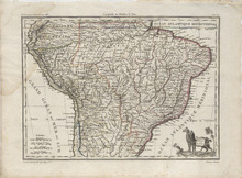
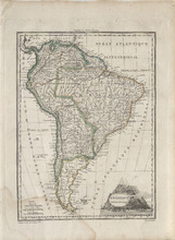
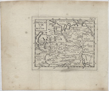
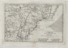
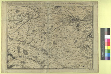
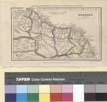
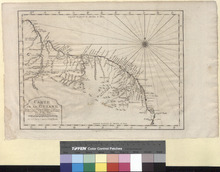
Map showing the whole South American Continent. The map is filled with a lot of geographic details concerning place names, rivers, lakes, mountains, and islands. The title is engraved inside a volcano. Cities on this map include: Natal, Paraiba (Paraíba), N. S. de Conceicao, Olinda de Fernambue, Peneda (Penedo), Sergipe del Rey, St. Salvador ou Bahia (Salvador), Villa do Ice, Joazeiro, Rio das Contas, Rio Grande, Ipoeira, St. George de Ilheos (Ilhéus), S. Antoine, S. Anna, Tapiracaba, Porto Seguro, Villa Boa, Arayal de Parucatu, S. Mathieu (São Mateus), Minas Novas, Villa do Principe (Serro), Espiritu Santo, Pitang, Sabara (Sabará), Guyate, Garipari, St. Joao del Rey (São João del Rei), Rio Janeiro (Rio de Janeiro), S. Paul (São Paulo), Paragua, S. Miguel (São Miguel), Villanova, Os Conventos, Taramandi, Viamao (Viamão), Bujuru, S. Pedro de R. Grande (Rio Grande), S. Borja (São Borja), S. Angelo (Santo Ângelo), S. Ignacio, Santa Anna, Cubacao, Villa Bella (Matto Grosso), Cuyaba (Cuiabá), Amarante, Resisto da Insua, S. Patricio (São Patrício), Crisa (Crixás), Lopes, Guarine, Villanova, Arcay, S. Felix (São Félix do Araguaia), Oeiras, S. Pedro, Aldeas Atlas (Aldeias Altas), Urubin, Natividade, Matanca (Matança), Casa Forte, S. Lorenco, Almeida, Anauhirahi, Cabexis, Des Incamento das Pedras, Fortalezza, Real ou Arrayal, Poyocao Nova, Olivenca (São Paulo de Olivença), Ega, Thomar, Barcellos (Barcelos), Moura, Forter. de Rio Negro (Manaus), Serpa (Itacoatiara), Ovidos (Óbidos), Santarem (Santarém), Almeirim, Pombal, Camota, Fragoso, Gurupa (Gurupá), Macapa (Macapá ), Mondim, Belem ou Gram Para (Belém), Ouren, Jozelea, Branganca (Bragança), Tapitapera, Joze, Aldea G., Piracunica (Piracuruca), Villa Vicosa (Viçosa do Ceará), Parnaiba (Parnaíba), Camosin (Camocim), Seara ou S. Joze de Ribamar (Fortaleza), Est Mayez, and Aracati, Brazil, Mangrullo, F. S. Therese (Fortaleza de Santa Teresa), Monte Video (Montevideo), and El Sacramento (Colonia del Sacramento), Uruguay, Yapeyn (Yapeyú), S. Baromben (Samborombon), Buenos Ayres (Buenos Aires), Areco (San Antonio de Areco), S. Sebastien (San Sebastián), Pergamino, S. Louis (San Luis), Mendosa (Mendoza), S. Juan (San Juan), Mercedes (Villa Mercedes), S. Augustin, Cordoue (Córdoba), Barada, Sta. Fe (Santa Fe), S. Lucie (Santa Lucía), Andrade, Zumampa, Santiago del Estero, S. F. de Catamarca (San Fernando del Valle de Catamarca), Vagna, St. Juan, Rioja la nueva Simbolan (La Rioja), S. Miguel de Tucaman (San Miguel de Tucumán), S. Joseph de Petacas, Corrientes, Candeturia, Paleipas, Malayas, Tala (El Tala), S. Felipe el Real de Salta (Salta), S. Sumen, S. S. Jujuy (San Salvador de Jujuy), and Calchaqui (Calchaquí), Argentina, Castro, S. Xavier, Osorno, Villarica (Villarrica), La Mocha (Valle de la Mocha), Valdivia, Sta. Fe, P. Rumena, La Concepcion (Concepción), Chillan (Chillán), St. Fernando (San Fernando), Astillero, Santiago, Legrone, Valparyso (Valparaíso), Quillota, S. Felipe Real (San Felipe), Mincha, La Serena, Huasco, Copiapo (Copiapó), Bas Chaco, Peine, Tarapaca (Tarapacá), Arica, and S. F. de la Selva, Chile, Ncembuen (Ñeembucú), S. Ignacio aband, Conception (Concepción), and Assomption (Asunción), Paraguay, Potosi (Potosí), La Plata (Sucre), Temina (Tomina), Pilaya, Cinti, Cotagayta (Santiago de Cotagaita), S. J. Baptiste, Plaine, S. Ana (Santa Ana de Velasco), S. Xavier (San Javier), Santa Cruz de la Sierra, S. Ignacio (San Ignacio de Velasco), Cochabamba, Oruro, Cicacica (Sica Sica), S. Nicolas (San Nicolás), Conception (Concepción), and La Paz, Bolivia, Tacna, Ililo (Ilo), Ica, Palpu (Palpa), Pausa, Camana (Camaná), Arequipa, Chucuyto (Chucuito), Sandia, Apolobamba, Challuanca (Chalhuanca), Chinchero (Chincheros), Abancay, Cuzco (Cusco), Xaura, Guancabelica (Huancavelica), Pisco, Canete (San Vicente de Cañete), Lima, Chancay, Huaillano, Guanuca, Truxillo (Trujillo), Caxamarquilla (Cajamarquilla), Caxamarca (Cajamarca), Sana, St. Antoine, Jaen (Jaén), Payta (Paita), S. Yago, Omagua, and Uraninas, Peru, Loja, Cuenca, Guayaquil, Macas ou Seville del Oro, Quito, S. Joseph de Huates, and S. Miguel, Ecuador, Ste. Foi, S. Paul, Pt. S. Louis, Casari, and Cayenne, French Guyana, Paramribo, Suriname, Stabrook (Georgetown) and Nle. Amsterdam (New Amsterdam) Guyana, Caroni, Thoina, Real Corona, Esmerelda, Cabiula, S. Carlos, Il d'Atureo, S. Fernando, M. de Carichama, Pampelune, Gibraltar, Truxillo (Trujillo), Maracaibo, Coro, Carora, Valence (Valencia), Leon (Caracas), Barcelone (Barcelona), and Cumana (Cumaná), Venezuela, Hiendo, Sta. Fe de Bogota (Bogotá), Girone, M. de Maypuri, Mira, Barbacoas, S. Juan de Pasta (Pasto), Popayan (Popayán), Carthago (Cartago), Sta. Fe de Antioquia (Santa Fe de Antioquia), Lorica (Santa Cruz de Lorica), Sta. Marta (Santa Marta), Cathagene (Cartagena), El Hacha, and Les Palme, Colombia, and Santiago (Santiago de Veraguas) and Panama (Panama City) Panama and the unknown locations of S. Tecta, S. Aria, Candeturia, and Fort. Source publication: Atlas Complet Du Precis De la Geographie Universelle De M. Malte Brun dressee par M. Lapie Capitaine Ingenieur Geographie Pierre M. Lapie (1779-1850) and his son Alexandre Emile Lapie (1809-1850) were French cartographers and engravers active in the early part of the 19th Century. The Lapies were commissioned officers in the French army holding the ranks of Colonel and Caipitan, respectively. Alexander enjoyed the title of "First Geographer to the King", and this title appears on several of his atlases. Both father and son were exceptional engraversand fastidious cartographers. Working separately and jointly they published four important atlases, an 1811 Atlas of the French Empire (Alexander), the 1812 Atlas Classique et Universel (Pierre), the Atlas Universel de Geographie Ancienne et Modern (joint issue), and the 1848 Atlas Militaire (Alexander). They also issued many smaller maps and independent issues. All of these are products of exceptional beauty and detail. Conrad Malte-Brun (1755-1826) was an important late 18th and early 19th Century Danish/French cartographer and revolutionary. Conrad was born in Thisted, Denmark. His parents encouraged him to a career in the Church, but he instead enrolled in the University of Copenhagen. In the liberal hall of academia Conrad became an ardent supporter of the French Revolution and the ideals of a free press. Despite the harsh censorship laws of crown prince Frederick VI, Malte-Brun published numerous pamphlets criticizing the Danish government. He was finally charged with defying censorship laws in 1799 and forced to flee to Sweden and ultimately France. Along with colleague Edme Mentelle, Malte-Brun published his first cartographic work, the Geographie mathematique, physique et politique de toutes les parties du monde (6 volumes published between 1803 and 1807). Conrad went on to found Les Annales des Voyages (in 1807) and Les Annales des Voyages, de la Geographie et de l'Histoire (in 1819). He also founded the Paris Societe de Geographie. In time, Conrad became known as one of the finest French cartographers of his time.

Insula Puna (1603)

Image
Map showing Isla Puna off present-day Ecuador. Europeans and Native Americans fight using guns or muskets. Settlement of dwellings and a church and boats being burned are seen in the background. There are ships and boats between the Island and the mainland. On the Mainland, Europeans attack Native Americans a who run away carrying a litter with someone inside it. The Cartographer, Levinus Hulsius, was a German writer who compiled an extensive collection of accounts of explorers' voyages published, ultimately, in twenty-six parts.

Russia in Europe. South part. [jmap057]

Image
Cities appearing on this map: Bulgaria: Varna. Turkey: Constantinople (Istanbul). Disputed Crimea: Sovastopol (Sevastopol), Simforopol (Simferopol) Russia: Krasnodar Krai: Anapa, Ekaterinordar (Krasnodar), Mamai (?), Adygea: Zapadnoi (Zapadnyy), Stavropol Krai: Stavropol, Aleksandrov (Alexandrovskoye or Aleksandriyskaya or Soldato-Aleksandrovskoye), Georgievsk (Georgiyevsk), Novogrigorevska (?), Mariksha (?), North Ossetia-Alania: Mozdok, Chechnya: Naur (Naurskaya), Volodimirovka (?), Georgia: Anacrai (?) Kumska, Kolpitchio, Starogladhovska, Kizlier, Tarki, Buinaki, Derbend, Niesabad, Dounghenti, Baku, Salian,

Carte De La Rade De Benguella et Riviere De Cantonbelle (1749)

Image
This is a copper engraved map of Benguella in modern day Angola printed in 1749 Jacques-Nicolas Bellin. Bellin was a famous 18th century mapmaker who focused mainly on nautical and coastal maps. This map is titled Carte De La Rade De Benguella et Riviere De Cantonbelle, which is translated to Map of the Roadstead of Benguella and the Cantonbelle River. A shows Endroit de la Riviere de Cantonbelle ou les Chaloupes vont faire de l'eau, which roughly translated to The Place of the Cantonbelle River or where the Sloops are able to travel by water. B shows Bras de Mer ou il y a quanlite de Caymans et de Baeufs Marins, which roughly translated to Inlet or the Bay of Caymans and Bay of oxen. The units shown are Une Lieue Marine de France et d'Angleterre or a Marine League of France and England. The map shows Ville de Benguella (Benguela) including Petit Fortin Ruine (Ruins of the Little Fort) and F. S. Philippe (Forte de São Filipe de Benguela) as well as Village de Negres (?), and F. Kabuto (?). In F. Kabuto, it says Les Anglois marquent ici apres Mr. Delisle le Fort de Kabuto je ne scan sur quel sondement which roughly translates into The English and Mr. Delisle mark Fort Kabuto Here and I put it in based on them.

Carte De La Partie Meridionale Du Bresil, Avec Les Possessions Espagnols qui en sont a L'ouest (1780)

Image
This is a copper engraved map from 1780 by Rigobert Bonne titled Carte De La Partie Meridionale Du Bresil, Avec Les Possessions Espagnols qui en sont a L'ouest, which, translated into English reads as, Map of Southern Brasil, With the Spanish possessions that are on the West Coast. It is from the atlas, Atlas de toutes les parties connues du Globe Terrestre (Atlas of all known parts of the World), Rigobert Bonne was a famous mapmaker from the 18th Century. The map covers the countries of Uruguay and Paraguay with parts of Northern Argentina, Southern Brazil, and Southern Bolivia. Cities appearing on the map: Argentina: S. Louis de la Punta (San Luis), Villa de la Vallee Fertile (?), Cordova (Córdoba), Sta. Fe (Santa Fe), Pergamino, Buenos Ayres (Buenos Aires), S. Fernando (San Fernando del Valle de Catamarca), S. Miguel de Tucuman (San Miguel de Tucumán), St. Yago del Ebero (Santiago del Estero), Sta. Lucia (Santa Lucía), Candelaria, Salta, and Juguy (San Salvador de Jujuy). Uruguay: Colonie du S. Sacrement (Colonia del Sacramento) and Mt. Video (Montevideo). Brazil: Sta. Tecla (Fuerte de Santa Tecla destroyed in 1801 and now just the ruins of the fort), Ciudad del Rio Grande de S. Pedro (Rio Grande), Viamon (Viamão), Villa de Laguna (Laguna), S. Francois (São Francisco do Sul), Iguilpe (Iguape), S. Vincent (São Vicente), S. Paul (São Paulo), S. Sebastien de Rio Janeiro (Rio de Janeiro), S. Juan del Rey (São João del Rei), Villa Rica ou Mariana (Mariana), S. Fr. Xavier (São Francisco do Guaporé?), Sta. Anne (Santa Ana), S. Felix (São Félix do Araguaia), Villanova do Principe (?), and Porto Seguro. Paraguay: Sta. Rose (Santa Rosa), Villa Rica (Villarrica), Assomtion (Asunción), Bolivia: S. Bernardo de Tarya (Tarija) and Sta. Cruz de la Sierra (Santa Cruz de la Sierra).

Carte Particuliere des Environs d'Arthois du Boulenois et d'Une Partie de la Picardie (1712)

Image
This is a copper engraved map of Northern France by Eugene Henry Fricx published in 1712. The title in French is Carte Particuliere des Environs d'Arthois du Boulenois et d'Une Partie de la Picardie and a rough English translation is Map of the Surroundings of Arthois Boulnois and Part of the Picardie. At the key it is written in French, Echelle de deux Lienes de Brabant which roughly translates in English to Scale of two Brabant Lines. Below it reads in French, A Bruxelles chez Eugene Henry Fricx rue de la Madelene aver Privilege du Roy 1708, which roughly ran slated in English to In Brussels Eugene Henry Fricx Street of the Madeleine with Privilege of the King, 1708. Cities appearing on the map: Nord-Pas-de-Calais-Picardie: Nord: Marquete (?), Koflande (?), Hasebrouk, Wate ou la Mote au bois(La Motte-au-Bois which is now part of Morbecque since the early 1790s), Steenbek (Steenbecque), Morbek (Morbecque), Fontainecastel (?), Zekele (?), Waloncapele (Wallon-Cappel), la Vostine F. O. C. (?), Ablinghem (Ebblinghem), Norstract (?), Bacouk (?), Renecrre (Renescure), Sille ou Linde (Lynde), Blaringhem, Boisinghem (Boëseghem), Tiene (Thiennes), Haveskerke (Haverskerque), Sanai capele (?), Wiacbrouq (Widdebrouck), and Pequeur. Pas-de-Calais: Bambek (?), Roughe F. ruine (?), Garlinghem, S. Floris (Saint-Floris), S. Venant (Saint-Venant), Amuzois (Les Amusoires), Robek Printe (Robecq), Le Quenol (?), Bune (Busnes), Garbek (Guarbecque), Le Moulenou (?), Bernoville (?), Berguete (Berguette, which, on January 1, 1996, consolidated with Molinghem and Isbergues to form Isbergues), Molinghem (Molinghem, which, on January 1, 1996, consolidated with Berguette and Isbergues to form Isbergues), Flandre (La Flandrie), P. en Bune (Pont en Busnes), Bunete (Busnettes), Canteraine (?), Manquevile (Manqueville), Ham H. O. S. (Ham-en-Artois), Pire (?), Orgevile (Orgeville), Cote (Saint-Hilaire-Cottes), S. Hilaire (Saint-Hilaire-Cottes), Malanoi (Norrent-Fontes), Norrem (Norrent-Fontes), Fonte (Norrent-Fontes), Tanai (?), les Mottes (?), Mazinghem, Breux (?), Isberge (Isbergues), Aire (Aire-sur-la-Lys), F. S. Francois (Fort St. Francis), S. Martin (Saint-Martin), Wit (Wittes), Jumele (La Jumelle), Rinck (Rinq), S. Quintin (?), S. Andrellas (?), Cohen (?), Quarq (?), Marte (Marthes), Mame (Mametz), Rebeck (?), Glominghem (Glomenghem), Cauchie d'Eck (There is a Fond de Cauchie and a Rue de Cauchie outside the city of Ecques), Warne, Roquetoir (Roquetoire), Ron (?), Ecoire (?), Raquinghem (Racquinghem), le Barne (?), Verderek (Wardrecques), Campagne (Campagne-lès-Wardrecques), Blandeque F. C. (Blendecques), Sorice (?), Quistede (Quiestède), Huringhem (Heuringhem), Pihen (Pihem), Helfaut, Bilk (?), St. Arque Comte (Arques), Wime (?), S. Bertin (Abbey of Saint Bertin inside Saint-Omer founded in the 7th Century that was closed during the French Revolution and is now Ruins), St. Omer (Saint-Omer), le Nar (?), les Chartroux (?), Longeunesse, Leulinghem, Wisq (Wisques), Wiserne (Wizernes), Haline (Hallines), Equerde (Esquerdes), Setque (Setques), Arqenbrone (?), Estrehen (Estrehem), Tatinghem (Merged to form Saint-Martin-lez-Tatinghem on January 1, 2016), le Hautoi (?), Cormete (Cormette), Disq (Petit Difques?/Grand Difques?), Noircarme (?), Quelme (Quelmes), Lumbre (Lumbres), Baynghem (Bayenghem-lès-Éperlecques/Bayenghem-lès-Seninghem), le Val du bois (?), Zud Ausq (Zudausques), Aquin (Joined with Westbécourt on January 1, 1974 to form Acquin-Westbécourt), Moringhem, Boidinghem (Boisdinghem), Bouvelinghem, Watine (?), Quercamp (Quercamps), Alquine (Alquines), Haut et Bas Locquin (Haut-Loquin/Bas Loquin), Waterdal (?), Colombi (Coulomby), Journi (Journy), Cauchie (?), Surque (Surques), Equeule (Escœuilles), Brunemberg (Brunembert), Reberg (Rebergues), Bainghem (Bainghen), Longuevile (Longueville), Coquerel (?), Cele (Selles), Bournonvile (Bournonville), Duche (?), Liane (There is a La Liane stream), Heneveu (Henneveux), Alingtun (Alincthun), Cremare (Crémarest), Belebrune (Bellebrune), Haute fontaine (There is a hotel called Gite Cottage des Hautes Fontaines), Bele (Belle-et-Houllefort), Contevile (?), Perne (Pernes-lès-Boulogne), Huplande (Huplandre), la Capele (La Capelle-lès-Boulogne), Pitefau (Pittefaux), Sauvre moulin (17th Century Chateau of Souverain-Moulin), Cuvervile (There is a street Chemin de Cuverville), Cluse (La Haute Cluse), S. Martin (?), Bedeutre (?), Boulemberg (?), Maquinghem (Macquinghen), Bertenlair (?), Baingtun (Baincthun), la Pature (?), Echinghem (Echinghen), S. Leonard (Saint-Léonard), P. De Brique (Pont-de-Briques), Hermeranq (?), Isque (Isques), Quehem (Quehen), Quetinghem (Questinghen), Hedin l'Abbe (Hesdin-l'Abbé), Oureq (?), Lanoi (?), Quetre (Questrecques), Wirevigne (Wirwignes), Reelinghem (There is a street Route de Reclinghen), S. Etiene (Saint-Étienne-au-Mont), Audisque (?), la Manoir (?), Ecame (?), Condete (Condette), Choquel (Le Choquel), la Hate (?), Chateau de Hardelot (Neufchâtel-Hardelot), Neuchatel (Neufchâtel-Hardelot), la Riniere (?), Pelinctun (?), Danne (Dannes), Camier (Camiers), Rombli ensable (?), Niele (Nesles), Verlingtun (Verlincthun), Menti (?), Floringtun (?), Hedigneul (Hesdigneul-lès-Boulogne), Tingri (Tingry), Carli (Carly), le Breuc (?), l'Epeche (?), Longuereque (Longuerecque), au bois Belazane (Bellozanne), Samer H. O. S. B., Pta. d'Estienfort (?), H. et B. Blefel (?), Wierre au Bois (Wierre-au-Bois), Le spreiet (?), Jourelingtun (?), S. Gertrude (?), Long Fosse (Longfossé), Courtaut (?), Canteraine, Chauffee (?), Devre (Desvres), Manevile (Menneville), S Martin (Saint-Martin-Choquel), Queque (Quesques), Buisson de Mai (?), Lotinghem (Lottinghen), Vieu Moutier (Vieil-Moutier), Monthulin rase (?), le Calique (?), Frinevile (?), Etaple (Étaples), Hilbert (?), Fromecen (Fromessent), Le Fau (Lefaux), Audiq (?), Goluque (?), Tubersen (Tubersent), Enoc (Bréxent-Énocq), la Roque (?), Courtevile (Courteville), Longviler H. C. (Longvilliers), les Prez (?), Courne (?), Rofenniel (?), Fren (Frencq), le Turne (?), Widehem, Cormont, Hubersent, Niembourg, Halinghem (Halinghen), Beutin, Atin (Attin), Brequesen (Bréxent-Énocq?), Marevile (Maresville), Etrayele (Estréelles), Tativile (Tatéville), Regue (Recques-sur-Course), Moncavrel ou Mailli (Montcavrel), Beussen (Beussent), Bernieul (Bernieulles), le Violier (?), Preurele (?), Enguinehaut, Rolers (?), Sequiere (Séquières), Veillame (?), Erime (?), Lacre (Lacres), Dale (Dalles), Parenti (Parenty), Doudeauvile H. O. S. A. (Doudeauville), Beauceroi (Beaucorroy), Cours (Course), la Croix de Pierre, Courset, les Chartrux (La Chartreuse de Neuville), Neuvile (Neuville-sous-Montreuil), Etree (Estrée), Marle (Marles-sur-Canche), Maren (Marant), la Beauce (?), Hurtevent (?), Sempi (Sempy), Aimi (?), Alete (Alette), Toutendal, Clenleu, Remortier, Maninghem au mont (Maninghem), Digitized 2-2015

Fort Rotterdam (1752)

Image
This is an engraved image of Fort Rotterdam in Makassar on the Indonesian island of Sulawesi published in 1752. The image is a birds eye view of the fort and at the bottom is a description in English and Dutch reading: Fort Rotterdam/Kasteel Rotterdam. It is labeled but no descriptions of the labeling exist. Jacques-Nicolas Bellin who lived from 1703 to 1772 was an important cartographer of the 18th century. He is understood as geographe de cabinet and a transitional mapmaker spanning the gap between 18th and early 19th century cartographic styles. His long career as Hydrographer and Ingénieur Hydrographe at the French Dépôt des cartes et plans de la Marine resulted in hundreds of high quality nautical charts of practically everywhere in the world. His work focuses on function and accuracy tending in the process to be less decorative than the earlier 17th and 18th century cartographic work. Unlike many of his contemporaries, Bellin was always careful to cite his references and his scholarly corpus consists of over 1400 articles on geography prepared for Diderot's Encyclopedie. In addition to numerous maps and charts published during his lifetime, many of Bellin's maps were updated (or not) and published posthumously. He was succeeded as Ingénieur Hydrographe by his student, also a prolific and influential cartographer, Rigobert Bonne. Jakob van der Schley who lived from 1715 to 1779 was a Dutch engraver and painter. He has engraved the maps and views of the maps of the Dutch edition of Prevost's Histoire General des Voyage.